Wednesday, November 26, 2008

Welcome Mr President (11/4)

Obama officially won the election as of Midnight on November 4, 2008 ... So now what can we expect? Hopefully, a bit of changes are on the way with a new leader, but far more depends on that that just who is US President. First of all, Obama will not officially be president until Inaguration Day, which is towards the end of January, 2009.In the meantime, GW Bush will continue to be president.

The US economy and military is not only reliant on who's running this country, but the people in our country as well. We all must work together as one, along with our government, and have hope things will improve during these tough times. God bless America, and the World too.
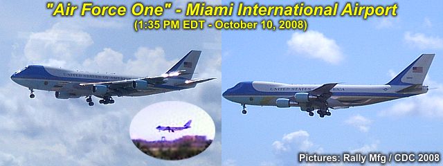


Air Force One, a military / government conversion of a Boeing 747-200B aircraft (designated as a VC-27A), makes it's final approach into Miami International Airport during the early afternoon of Friday, Ocrober 10, 2008. This plane is a highly customized "Oval Office in the sky" and allows the president, G W Bush (onboard at the time) to be capeable of running the country from this plane in the event the US is under attack or any other circumstances making Washington DC not an option.

The plane has a range of just under 8,000 miles, can fly at speeds up to 630-MPH, and has a service ceiling of about 45,000 feet. The plane is seen here, in the landing configuration, with the distinct white and light blue livery and US government emblems.

You can also read about our conditions in America and other political / racial subjects in my section called "AMERICA" on this web-site. You can also jump right to that section by clicking the link below...

http://www.sky-chaser.com/america.htm
Tiny TS Marco (10/7)

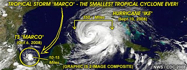
Tropical storm Marco formed during the beginning of October 2008 and struck Mexico's Bay of Campeche coast as a 65-70 MPH tropcial storm. This storm, however, was very unique because it was the smallest tropical cyclone ever observed, with a tropical-storm forced wind field width of only 10-15 miles - A large thunderstorm complex is larger!


The annotated to-scale diagram above compares the size of hurricane "Ike" (in September 2008) with that of Tropical storm "Marco", less than a month later, which is barely discernable in the Bay of Campeche to the lower-left (look carefully)! The previous record for the smallest size of a tropical storm's gale envelope was with tropical cyclone "Tracy", with a 30-mile wide wind-field, back in Australia in the early 1970's.

For the records, the widest tropical cyclone (measured across the wind swath of winds at or greater than 38-MPH) was super typhoon "Tip" in the Pacific back in 1979, at an astonishing 1,200 miles across!