Thursday, August 16, 2012

Tropical August Begins (8/6)

The tropical Atlantic is started to get busy as we headed into the second week of (early) August 2012. There were tropical storms Ernesto, Florence, and Gordon. Ernesto became a hurricane near Mexico and the other two remained far out at sea.


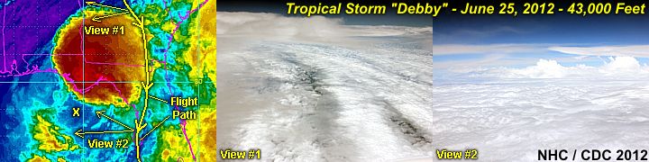
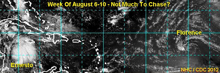
Hurricane Ernesto moved into the southern portions of the Yucatan Peninsula as a category one hurricane during the late night of Aug 7-8. The night landfall discouraged any chasing of Ernesto (only chaser Josh M from California went there for it). Ernesto weakened in Mexico, but eventually crossed into the eastern Pacific, forming tropical storm Hector. The other two storms, Florence and Gordon, affected only the open north Atlantic and bothered no one as they remained well out to sea (what hurricane chasers call a "fish storm").

Be sure to keep up to date with any tropical activity in the TROPICS section in my STORM CHASING area of my web site. You can also go right to that area (for tropical activity) via the link for it below.

http://www.sky-chaser.com/tropics.htm

Monday, August 06, 2012

Sad USA Moments (7/21)

Simply going to 'dinner and a movie' became far more dangerous in Colorado this week (as of July 20) than skydiving in the eye of a hurricane (statistically that is)! The PERSON who did this is a pure MONSTER, evil as much as (if not MORE than) a terrorist.


This composite image above shows the flags at my skydiving facility at half mast, overlaid to a stock image of INNOCENT folks at a movie - I HOPE this gets some sort of message across. God bless us all, we all will NEED it. For more information on the SAD situation here in the USA, please see my section on AMERICA, which is also available at the link below (make sure you have the 'Kleenex' handy)!

http://www.sky-chaser.com/america.htm

Tropical Storm "Debby" (6/25)

Tropical storm "Debby" formed in the NE Gulf Of Mexico on June 24. This was the FOURTH named tropical cyclone of the 2012 Atlantic hurricane season. In the image below, the "topside" of TS Debby can be seen from a high-flying commercial airliner (en-route from Toronto to Miami) at nearly 43,000 feet!


In the next image below, the storm can be seen as of June 26 as it was about to cross N Florida as a weak tropical storm / depression.


No intercept was done on the storm because of its weak structure. Debby caused severe flooding in Northern Florida, as well as some tornadoes on June 24 in other parts of the state. 2012 has got off to an extremely busy start, with four named storms before the end of June! Keep track of any tropical systems and hurricanes (and plans to chase them) with via the link for it below.

http://www.sky-chaser.com/tropics.htm

Hurricane "Chris" (6/22)

You would think the THIRD named tropical storm (and the FIRST hurricane) of the 2012 Atlantic hurricane season would have my name (tropical storm / hurricane "Chris") on it and be something to chase? Nope, another storm far from any land and a weak system that churned away in the far north Atlantic, but became a hurricane (briefly) on June 21-22. The 2012 tropical season has got off to a busy start, with two named systems BEFORE June 1 (the official start of the Atlantic hurricane season) forming in the Atlantic basin.


Tropical storm Chris, the third named storm of the season, formed in the north Atlantic on June 19, 2012. It bothered no one as it remained well out to sea (what hurricane chasers call a "fish storm"). The storm managed to reach hurricane Intensity on June 21, making it the first minimal hurricane of the 2012 Atlantic season.

Be sure to keep up to date with any tropical activity in the TROPICS section in my STORM CHASING area of my web site. You can also go right to that area (for tropical activity) via the link for it below.

http://www.sky-chaser.com/tropics.htm