Thursday, January 29, 2009

2009 Everglades Boogie (1/24)

The "Everglades skydiving boogie" is a rather large skydiving event that was held again in 2009 (in it's second straight year since 2008) in Clewiston, Florida at Air Adventures. This event was held from January 23-25 and had a large aircraft lineup ... For skydiving: 2 twin Otters, a Sky-van, a Bell 412 helicopter, and a Pitts Special. For rides: An Extra 300, hang gliding, and an L-39 jet fighter!


What an awesome event, fabulously put together by the great folks at Air Adventures! You can check out this event, along with many others, in my SKYDIVING section of my web site. You can also jump right to the link by clicking link provided below ...

http://www.sky-chaser.com/skydive.htm

New US President - Barack Obama (1/20)

The United States just sworn-in our new president, Barack Obama, the 44th president of the United States just after high-noon on January 20, 2009. Obama is the first African American to become president of the United States, and hopefully will be a message to both our country as well as an influence and inspiration many others here and around the World.


The United States is going through rather hard times right now as of 2009, and it's going to take a good president AND a good heart to put the USA back on its tracks. We all welcome our new president and hope he fulfills his duties to its fullest and wish all of us the best of luck!

Great White North Boogie (1/17)

The "Great White North skydiving boogie" is a small skydiving event held each year in mid January in Lake Wales, Florida. The Florida Skydiving Center in Lake Wales is a great place to skydive and is a facility undergoing major rennovations, including a new hangar, nearly 5 years after being devastated by hurricane Charley back in 2004.


You can check out this event, along with many others, in my SKYDIVING section of my web site. You can also jump right to the link by clicking the link provided for it below ...

http://www.sky-chaser.com/skydive.htm

New Year Of 2009 (1/1)

Welcome to 2009 and a whole new year! Like 2008, which was a fantastic year for me personally and especially for storm chasing, 2009 should be hopefully the same if not better.


The 11th annual National Storm Chaser Convention will again take place in February 2009 and I will be attending this event. The NSCC web-site can be seen by clicking the link provided for it below ...

http://www.chaserconvention.com

Storm chasing logs are completed for 2008 and can be seen in the STORM CHASING section of this web site. In the storm chasing section, all chase logs, including chase trips and "regular" logs are up to date as of the end of 2008. You can jump right to that section by clicking the link below ...

http://www.sky-chaser.com/stormc.htm

Monday, December 29, 2008

Happy Holiday Season (12/6)

Welcome to December 2008 - Last month of the year, and the start of winter ... Actually, winter begins December 21 - But like the hurricane season, winter is a season that does not necessarily follow "rules".


In December 2008, an interesting grouping of Venus and Jupiter took place in the evening sky. The view of this planet pair was even more majestic as seen above Tampa Bay at 41,000 feet just after sunset (left above). A cold front pushes through Florida making a shelf / roll cloud over Miami, Florida (center), dropping the temperature there into the 40's at night. Up north, in Michigan, winter has an ealry grip in the Great Lakes region, with temperatures well below freezing, snow, and ice-covered railings (right image)!

The Atlantic hurricane season officially ended on November 30 and has been an above-average season. Now it the time to plan for next years chases, as well as go over footage from this year ... Which has been released in a new storm chasing DVD entitled "Storm Chasing 2008 - Extreme Seasons", so make sure you check the "special offers" section below for it.

Once again, the holidays of 2008 are here and I wish everyone a happy and safe holiday and travels ... And most importantly a great new year of 2009!

Tuesday, December 02, 2008

Chase 2008 DVD Released (12/2)

See mother nature and weather at their worst with the 2008 "Extreme Seasons" DVD! Nearly two hours of compelling footage starts with one of the earliest-in-the-season tornado events near Memphis, Tennessee on "Super Tuesday" (Feb 5, 2008) followed a bone-chilling lake-effect "frozen hurricane" blizzard in coastal (Great-Lakes) Michican just 5 days later! Then its off to "Tornado Alley" in the Spring of 2008 with some of the most violent tornadoes, up-close and personal (maybe even too close)! This presentation is not for the faint-of-heart, and some footage will have you on the edge of your seat.


See tornadoes directly impacting storm chasers, literally becoming more of "the chased" than "chasers". Watch a large "satellite" stove-pipe tornado go around a mile-wide wedge tornado with 100+ MPH RFD winds as day becomes night. See gigantic hail total a car in minutes. Watch muddy Kansas dirt roads turn into vehicle "fly traps"! See some of most impressive supercell structure ever observed.

After tornado season, it's time for hurricane chasing, with tropical storm Fay and hurricanes Gustav and Ike in the Summer / Fall of 2008. See the eye of a hurricane's calm star-lit skies in Ike, followed by a 15-20 foot storm surge as Galveston, Texas is both put underwater parts set on fire. Watch the mass evacuations before and daring rescues / piles of boats left behind in the aftermath. See a rare commercial airline flight high across the eye of tropical storm Fay! This DVD has just about every extreme and raw power of the four seasons!

To view more information on this video (or how to order a copy of it) - Check the link provided below ...

http://www.sky-chaser.com/offers11.htm

Wednesday, November 26, 2008

Welcome Mr President (11/4)

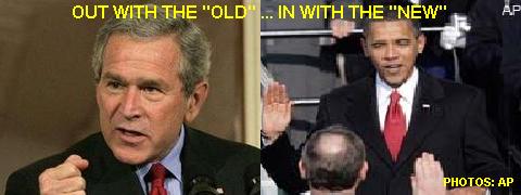
Obama officially won the election as of Midnight on November 4, 2008 ... So now what can we expect? Hopefully, a bit of changes are on the way with a new leader, but far more depends on that that just who is US President. First of all, Obama will not officially be president until Inaguration Day, which is towards the end of January, 2009.In the meantime, GW Bush will continue to be president.

The US economy and military is not only reliant on who's running this country, but the people in our country as well. We all must work together as one, along with our government, and have hope things will improve during these tough times. God bless America, and the World too.


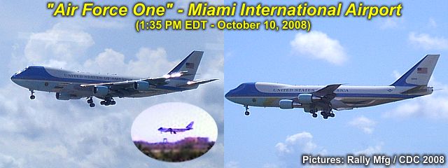
Air Force One, a military / government conversion of a Boeing 747-200B aircraft (designated as a VC-27A), makes it's final approach into Miami International Airport during the early afternoon of Friday, Ocrober 10, 2008. This plane is a highly customized "Oval Office in the sky" and allows the president, G W Bush (onboard at the time) to be capeable of running the country from this plane in the event the US is under attack or any other circumstances making Washington DC not an option.

The plane has a range of just under 8,000 miles, can fly at speeds up to 630-MPH, and has a service ceiling of about 45,000 feet. The plane is seen here, in the landing configuration, with the distinct white and light blue livery and US government emblems.

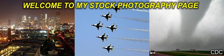
You can also read about our conditions in America and other political / racial subjects in my section called "AMERICA" on this web-site. You can also jump right to that section by clicking the link below...

http://www.sky-chaser.com/america.htm

Tiny TS Marco (10/7)

Tropical storm Marco formed during the beginning of October 2008 and struck Mexico's Bay of Campeche coast as a 65-70 MPH tropcial storm. This storm, however, was very unique because it was the smallest tropical cyclone ever observed, with a tropical-storm forced wind field width of only 10-15 miles - A large thunderstorm complex is larger!


The annotated to-scale diagram above compares the size of hurricane "Ike" (in September 2008) with that of Tropical storm "Marco", less than a month later, which is barely discernable in the Bay of Campeche to the lower-left (look carefully)! The previous record for the smallest size of a tropical storm's gale envelope was with tropical cyclone "Tracy", with a 30-mile wide wind-field, back in Australia in the early 1970's.

For the records, the widest tropical cyclone (measured across the wind swath of winds at or greater than 38-MPH) was super typhoon "Tip" in the Pacific back in 1979, at an astonishing 1,200 miles across!

Saturday, September 20, 2008

Hurricane Ike (9/12 - 9/13)

Hurricane Ike hit Galveston, Texas on September 12-13, 2008 and - again - my chase partner and I were there! Landfall packed winds near 110-MPH with devastation, storm-surge, and even fires.


The chase log for my hurricane Ike intercept in SE coastal Texas / Galveston Island is available in the STORM CHASING section of this web site. You can also click the link provided below to check the section for hurricane Ike ...

http://www.sky-chaser.com/ike08.htm

Saturday, September 06, 2008

Hurricane Gustav (9/1)

Hurricane Gustav hit SW Louisiana on September 1, 2008 and my chase group and I were there! Landfall packed winds near 110-MPH with devastation just 3-years after hurricane Katrina.


The chase log for our hurricane Gustav intercept in the northern Gulf Coast is available in the STORM CHASING section of this web site. You can also click the link provided below to check the section for hurricane Gustav ...

http://www.sky-chaser.com/gustav08.htm

Flying Over TS Fay (8/22)

The image below is a panoramic view of the circulation center of Fay, taken on August 22, viewed from a commercial jet aircraft flying over the storm at about 38,000 feet!


The picture above was when tropical storm Fay was inland over North and Central Florida, and being over-flown by a commercial airliner enroute from Fort Lauderdale to Chicago.

More information on tropical storm Fay can be seen at the link below ...

http://www.sky-chaser.com/fay08.htm

Tropical Storm Fay (8/19)

Tropical storm Fay was intercepted in SW Florida on August 19, 2008. Tropical storm Fay was an interesting storm because it made MANY landfalls (2 in the Caribbean, and 4 in Florida alone) and had a very strange track from August 15 through August 24. In Florida, it made landfall near Key West, then on the SW Florida coast, then re-emerged into the ocean near Cape Canaveral, only to make a third landfall near Daytona Beach, cross the state, then re-emerge over the NE Gulf of Mexico, and make a final landfall near the FL Panhandle.


The storm packed winds up to 65-MPH and dumped over 20 inches of rain in less than a weeks time during its chaotic path across the state of Florida. You can check out my full chase log on Fay by clicking the link provided below (for my STORM CHASING section) ...

http://www.sky-chaser.com/fay08.htm

Hurricane Dolly (7/23)

The Atlantic hurricane season of 2008 came alive on July 23 with a vengence as Hurricane Dolly, the first hurricane to strike the US in 2008, came ashore in Texas just north of the Mexico / US border at about 2 PM CDT packing winds of 100-MPH. This is a category-2 storm on the Saffir-Simpson scale.


I was not able to intercept this storm (unfortunately) but you can check out the tropical season of 2008 by a special section called "TROPICS" in the STORM CHASING area of this site. The tropics will continually be monitored in 2008 for any activity to study or even intercept!

Click the link below to jump right to my section on tropical weather ...

http://www.sky-chaser.com/tropics.htm

Liquid-Sky Boogie (7/19)

The "Liquid-Sky" skydiving boogie (special event) was from July 18-20 in Clewiston, Florida at Air Adventures skydiving. This event included some hot summer skydiving fun, as well as aerobatic rides!


You can check the SKYDIVING and FLYING sections of this site for pictures and details on this fun event. These pictures can also be seen by clicking the links provided below.

Below is the link for skydiving events, such as this one ...

http://www.sky-chaser.com/skydive.htm

Below is the link to my FLYING section, including aerobatics ...

http://www.sky-chaser.com/flying.htm

Tuesday, July 15, 2008

Southern California (7/4)

Southern California is a place in the United States that has "something for everyone". Besides the most obvious "Hollywood" and "Beverly Hills", no one can ignore the collaberation of culture and diversity in this area. Southern California also offers a lifestyle like no other, from beaches to theme parks.


Be sure to check out what visiting (or living in) california is like by checking out the OUTDOORS section of this site. These pictures can also be seen by clicking the link provided below ...

http://www.sky-chaser.com/outdoors.htm

Canada's Class-5 Rapids (6/29)

Canada is noted for its impressive beauty and appeal to the outdoor adventurer and sportsman alike. In the pictures above, you can see and almost feel the power of the Niagara River aboard a jet boat specially designed to drive right THROUGH class-5 rapids!


Check out many pictures of Canada and many other exciting destinations by checking out the OUTDOORS section of this site. These pictures can also be seen by clicking the link provided below ...

http://www.sky-chaser.com/outdoors.htm

Indiana Supercell (6/22)

A "suprise" chase was conducted with the start of the summer season in northern Illinois / Indiana on June 22, 2008 with a buddy of mine who "always wanted" to ride along on a storm chase with me!

Not expecting much, we both were awarded with a pretty little supercell storm that put out hail up to golfball sized (near Pulawski, Indiana).


A small chase log has been added to the LARGE section for the MIDWEST 2008 chase logs in the STORM CHASING section of this web site and can also be seen by clicking the link to it provided below ...

http://www.sky-chaser.com/mwcl2008.htm

Chase Trip 2008 (5/19 - 6/1)

I have finished a fantastic storm chasing trip in the central USA (Tornado Alley) from May 19 through June 1. The overall pattern for severe weather in this region was very active and many tornadoes have been intercepted during the trip!


Information on this storm chasing trip is available in the STORM CHASING section for MIDWEST CHASE LOG 2008 and can also be seen by clicking the link to it provided below ...

http://www.sky-chaser.com/mwcl2008.htm

Friday, May 16, 2008

Another Chase Trip (5/1 - 5/2)

A special "spot" chase was done during the week of May 1, 2008 with a special trip that left Florida on the evening of April 29 and into Kansas City, Missouri to be in position for severe storms and tornadoes on May 1 (and possibly May 2). A tornado was intercepted in Warren County, Kansas on May 1!


The May 2 target proved to be too far from Kansas for any intercepts, so an alternate northern target was sought with smaller storms intercepted there. The remainder of the time (no storms) was spent in Chicago with a return to Florida on May 5 (back from Chicago instead of Kansas City).

The chase log for this storm chase is also online and can be seen by clicking the link to it provided below ...

http://www.sky-chaser.com/mwcl2008.htm

Sunday, April 13, 2008

Storm Chase Trip (4/8 - 4/11)

A special "spot" chase was made during the second week in April 2008 from the 8th through the 11th. Some tornadoes and extreme weather was caught on April 9, 2008 in west-central Texas, including a destructive tornado in Breckenridge, Texas. On April 10, attention shifted east into Arkansas, where extreme flooding was observed.


The chase log for this storm chase is also online and can be seen by clicking the link to it provided below ...

http://www.sky-chaser.com/mwcl2008.htm

Thursday, April 03, 2008

Back In Florida (3/31 - 4/2)

I finally wrapped up a very interesting, fun, and productive 3-month stay in the Chicago area with a storm-chase in Missouri / Arkansas on March 31 (while starting my long drive back to FL). April 1 and 2 were travel days and I finally arrived safely back in FL during the morning of April 2.


In the images above, a severe storm can be seen in SW Missouri on March 31. In the middle, highway 78 stretches through rural Alabama and Mississippi en-route to Florida on April 1. To the right, The "Weatherlab" portable weather station gets a new Oregon Scientific WMR-968 plus a re-design for storm chase season 2008!

Monday, March 24, 2008

Last Winter Storm? (3/21)

Spring has arrived in Chicago as og Friday, March 21, 2008 but that does not mean winter is over just yet. A late-season snow-storm struck the northern Midwestern US leaving a narrow blanket of snow from Minnesota through Wisconsin / Illinois and into Michigan. The snow "swath" in Illinois was confined to the extreme northern portions of the state (north of Chicago) and into southern Wisconsin, where 10 to 12" of snow fell.


The snow "swath" was so distinct that the northern portions of Chicago had 6 to 8" while the southern portions saw only a light dusting! In the pictures above, a beautiful winter scene plays out in Chicago's northside and far-northern suberbs after the storm departs and sun comes out. The Chicago area has had one of the worst winters in about 30 years for 2008.

Tuesday, March 18, 2008

California Cold-Core Storms (3/15)

A region of vorticity aloft, accompanied by very cold air aloft, allowed storms to develop in the otherwise stable cool Pacific air mass. Winds were from the northwest with temperatures in the 60's.


The picture above shows some intense thunderstorms, including a cold-air funnel and small hail, in a place unlikely for storms - Central California! These storms were encountered while in the central California area for a weekend with friends.

Be sure to check out this event, along with many others for 2008 in the storm chasing area of my website, or click the link below to go right to it...

http://www.sky-chaser.com/mwcl2008.htm

Monday, March 10, 2008

Stock-Photo Page Added (3/1)

I am now pleased to offer high-quality and high-resolution digital imagery of nature, storms, urban, and many other compositions for delivery via postal mail or email delivery with easy payment options, including Paypal!


All images for sale are royalty free and unlimited usage at the flat-rate of $10 per image. Delivery via email is free ($10.00 total)> Shipping via USPS is in the form of an 8" x 10" image centered on glossy 8.5" x 11" photo stock, and is $3.00 extra ($13.00 total).

For more details, please check the special OFFERS section of this site and look for the digital photography link, or simply click the link below to go right to that section...

http://www.sky-chaser.com/offers10.htm

Tuesday, February 26, 2008

Nat'l Storm Chaser Convention (2/16)

The National Storm Chaser Convention (NSSC) was from February 15 to 17, 2008 at the Raddison in Aurora, Colorado and was excellent with a great turnout! Close to 300 storm chasers and their associates attended this event.


The agenda included excellent presentations ranging from photography, storm dynamics, forecasting, even high-speed lightning photography by Tim Samaras and a wonderful presentation of US Plains history by Dave Hoadley to name a few.

Special thanks to Roger Hill and Tim Samaras for such great planning and organizing this event. More pictures can be seen in the storm chasing events for 2008 link provided below...

www.sky-chaser.com/picnic08.htm

Extreme Snow Mobiling (2/15)

What a time to spend the day before the start of the Colorado National Storm Chasers Convention - Extreme snow-mobiling! My group of storm chasing friends and associates took a back-country snow mobiling tour deep in the Colorado Rockies and along the top of the Continental Divide and at elevations approaching 13,000 feet above sea level!


This is by far the best way to see some of the best mountains in North America, and the weather was sunny, clear, and cold - Permitting a line of sight exceeeding 160 miles! The snow pack was as high as 400 inches in some high-altitude mountain areas - That's over 30 feet!

Click the link provided below for more pictures and information ...

www.sky-chaser.com/skydive.htm

Tuesday, February 12, 2008

Brutal Lake-Effect Snow (2/10)

February 10, 2008 brought a nasty Canadian "Alberta Clipper" cold front across the north and Great Lakes region with temperatures near -10 degrees F below and wind-chills in the -30's ...


... So where did I go? The beach! See the brutal lake-effect snow in Saint Joseph, Michigan along with huge waves and 50-MPH winds during the morning of February, 10 at the link provided below...

www.sky-chaser.com/winter.htm

Thursday, February 07, 2008

"Super-Tuesday Outbreak" Chase (2/5)

A significant severe weather / killer tornado outbreak took place in the south-central US on February 5, 2008. This was called the "Super Tuesday Tornado Outbreak", and killed at least 59 people. Particularly hard-hit was the western Tennessee area (near Memphis) and parts of Arkansas where deadly and destructive tornadoes hit during the afternoon and evening.


- STORM CHASING IS NEVER PLEASANT WHEN PEOPLE ARE BEING HURT -
- GOD BLESS ALL THOSE AFFECTED BY THIS TORNADO OUTBREAK -

I was able to chase and tackled this difficult and extremely dangerous setup with a trip from Chicago to Memphis (500 miles each way)! There is a full report on this event and is available at the link below...

www.sky-chaser.com/mwcl2008.htm

Snowstorm Then "ThunderFog" (2/4)

Amazing to see a snow storm on 2-3 in Illinois, then, just 24 hours later, I am on a storm off I-65 in Lake County, Indiana chasing a thunderstorm with frequent lightning, small hail, and 50-MPH winds!


In the pictures above, we can see cloud-to-ground (CG) lightning strike to the far right, with blowing FOG ... Yes - That white on the ground to the left of that picture is snow. In the left picture, a car spins out and hits someone in front of me in a snow storm with 4" on I-94 / I-80.

You can also check out a chase report for the thunderstorms on 2-4 at the link below...

www.sky-chaser.com/mwcl2008.htm

Monday, February 04, 2008

Winter Weather! (2/2)

The weather in Chicago this year of 2008 has been anything but boring. One day it's extremely cold and sunny, the next day its 50 degrees and foggy, then a line of thunderstorms moves through, and by that evening, a 6-12" snow storm hits!


In the pictures above, parts of Lake Michigan are frozen solid. The middle picture shows a nasty commute to work in a snow storm - Good for kids, who were off from school - But not for people driving in it. The picture to the right shows small icebergs floating in Lake Michigan. Actually, they are simply chunks of pack-ice that break apart when lake ice shifts due to strong winds.

Frigid temperatures allow even a large body of water such as the Great Lakes to develop ice.

Saturday, February 02, 2008

Skydiving And An L-39 Jet (1/26)

I attended the Everglades Skydiving Boogie event held at Air Adventures in Clewiston, Florida during the weekend of January 25-27, 2008! This was an awesome skydiving event with at least four jump aircraft (Balloons, Helicopter, Super Otters, and Skyvan) and had a tremendous turnout and good weather most of the time.


The event even allowed both skydivers and non-skydivers to get a ride in two incredible aerobatic aircraft, an Extra 300 or an L-39 jet fighter! You can check out this event in the SKYDIVE section of this web-site or simply click the link provided below...

www.sky-chaser.com/skydive.htm

For my second time in my life, I was able to fly aboard an L-39 fighter jet at Airglades Airport in Clewiston, Florida during the Everglades Skydiving Boogie 2008! On this flight, a unique POV concept was used, and the video is there to prove it! The video is finished, and is also available at the link provided for it below.


Several pictures of the flight (along with those from a similar flight at WFFC in 2006) have been posted in the FLYING section of this web site. See what it's like to buzz clouds and come within 15 feet of the ground at over 300-knots while nearly passing out with over 6 G's of force pressing on you!

For the FLYING section, you can click the link provided below...

www.sky-chaser.com/flying.htm

For a video clip of the L-39 flight, you can also click the link provided below...

www.sky-chaser.com/l39vid.htm

Chasing Lake-Effect Snow (1/19)

An interesting observation was done to pass some frigid "winter" time on January 19, 2008. This involved a lake effect snow event in Michigan, about an hour's drive from where I am staying in Chicago's south side. With a Canadian / Arctic blast, temperatures in Chicago struggled to get above zero degrees F on Jan 19th, with clear and sunny skies.


In Michigan, near Saint Joseph, conditions were a mere 10 degrees warmer, with blowing and drifting snow racing on-shore from Lake Michigan in a scene very reminiscent of a "frozen tropical storm"!

You can check out such extreme winter weather in the WINTER section of the storm chasing area of this web-site, or simply click the link provided below...

www.sky-chaser.com/winter.htm

Chicago Severe Storms (1/7)

A rather unusual (for January that is) weather setup unfolded across the US Midwest on January 7, 2007 ... The pictures above wer taken as the storm complex (strong and severe thunderstorms) moved through the Chicago area after dark. The Sears tower antenna spires were struck several times! Even more interesting, the picture to the far right shows a rare positive polarity strike - common with winter thunderstorms - branching upwards into the sky.


Apart from lightning and flooding in Chicago, the storm system produced severe storms from Oklahoma to Wisconsin, including damaging tornadoes - most likely the earliest to occur in any given season.

Hard to imagine that just 5 days prior, these same regions were blanketed with snow and frigid arctic air! Chicago had temperatures in the 60's before the storms rolled in.

You can also check out a chase report for this event at the link below...

www.sky-chaser.com/mwcl2008.htm

Friday, January 04, 2008

Midwestern Winter Storm (1/1)

Driving up from Florida to Chicago was easy ... The first 90% of the trip - That is! I was able to leave Fort Lauderdale early morning on December 31, 2007 and drive straight through (little traffic and great weather) to Indianapolis, IN where I spend the night. The short leg from Indianapolis to Chicago was right into blizzard conditions, with gale-forced winds, moderate snow, and drifting snow. The Interstate was OK, but the country roads, shown above, were very dangerous.


About 3 to 9 inches of snow was observed, depending where you were from NW Indiana into Illinois. Temperatures were in the 20's then dropped to near 0 degrees F behind the storm system. A powerful winter storm moving across the great lakes caused the snow and wind.

See more details on this storm and more exciting winter weather at it's worst by clicking the link provided below...

www.sky-chaser.com/winter.htm

Thursday, December 27, 2007

Off To Chicago (12/31)

Once again, spending 3-4 months or so on a computer project with the University of Chicago starting January 2, 2007 ... Most likely not many storms to chase there - It's the dead of winter and there will, however, be lots of snow, ice, and cold windy weather!


The programming (PICK / MV) project is temporary and should be done in the time-frame shown (or less if something else locally in FL comes up).

Post-Season TS "Olga" (12/12)

Just when we think the 2007 Atlantic Hurricane Season is finished a new tropical storm forms - In DECEMBER - Tropical Storm "Olga"! December storms are rare, but do happen occasionally. This one is interesting as it affected the Caribbean as it headed to the west, an unusual direction for this time of year, due to abnormally strong high-pressure to its north.


The storm headed west and continued weakening as it headed into a region of higher vertical shear / dry air in the western Caribbean - Typical in the tropics in December. The storm eventually weakened into a remnant low and reached the Yucatan Penninsula as no more than a swirl of low clouds before dissipation.

Landspout Tornado (12/8)

Small landspout tornado observed in Palm beach County near South Bay east of Highway 27 in Florida! This was a small tornado (most likely EF-0) that formed along the lake-breeze boundary and under low-topped convective cells.


The landspout lasted about 10 minutes and weakened before reaching Highway 27. In the picture, a clear ground circulation is visible and funnel above it on the parent convective shower - A tornado is a "tornado" - And to much amazement on such a fair-weather day!

Monday, November 19, 2007

Alcatraz Island (CA 11/19)

See the island of Alcatraz and US Penitentiary in the San Francisco Bay! This island was home to a federal prison from 1934 through 1963.


You can check out the link provided below for more information on the wonders of Alcatraz...

www.sky-chaser.com/alcatraz.htm

Wednesday, October 31, 2007

Tropical Storm Noel (FL - 10/31)

Tropical storm Noel passed east of Florida on Halloween 2007 (October 31) but affected the east coast of southern Florida with very high waves and winds well over gale (tropical storm) forced. Check out the footage of this rather weak but interesting tropical system.


You can check out the link provided below for more information on this observation / coastal chase of tropical storm Noel...

www.sky-chaser.com/noel07.htm

Long Island NY (9/25)

Any hint on what the picture below is? Where is it? This is central Long Island, New York, viewed from an altitude of about 23,000 feet on a warm and clear Indian Summer day. The importance of this place is that it's where I grew up, went to school, and lived until I was 16 years old. If you look closely, you can make out a small lake just below the center of the image, that's Lake Ronkonkoma, and my surrounding home-town.


Flying gives one a whole new perspective on our world and where we live. Whether you are an avid pilot, or weary traveler, the view outside the window on that delayed flight just might give you a whole new way one can look at (and appreciate) our world miles below. I have a large collection of flying footage and pictures. You can click the link below to check out my section on flying ...

http://www.sky-chaser.com/flying.htm

Wednesday, September 12, 2007

Remembering 9-11-2001 (9/11)

REMEMBERING SEPTEMBER 11, 2001 ... It has been 6 years since America was attacked by terrorists on that fateful day of September 11, 2001. A good friend of mine described over lunch his horror of seeing the collapse of the World Trade Center from New Jersey 6 years ago on that fateful day.


In rememberance, please visit the link below to remember those lost as we will NOT forget all lost on that terrible day...

http://www.sky-chaser.com/america.htm

Eric Nguyen Passes (9/9)

Eric Nguyen, a close storm chasing associate of mine, passed away on September 9, 2007. Eric was a fantastic storm chaser, forecaster, scientist, and meteorologist and will be missed by many. He is survived by two kids, his wife, and many relatives as he passed at only age 29.


Our love and sorrow goes out to all, especially friends and family, after such a sensless and unfair passing of such a great and enjoyable person. Please visit the link provided below to see more information, including a special scholarship foundation in his name...

www.ericnguyengathering.com

Saturday, September 08, 2007

Skydive Monterey Bay (9/1)

Cool trip to California this past Labor Day weekend of 2007 included a trip to Skydive Monterey Bay near Marina, California. Two jumps from over 18,000 feet were done, the second one a really nice 10-Way RW attempt!


Be sure to check out the pictures in my SKYDIVE section on this site. You can go right to the link by clicking the link provided below ...

http://www.sky-chaser.com/skydive.htm

Hurricane Felix (9/4)

Landfalls of category-five hurricanes are rare, and this is the second one this year. Before hurricanes Dean and Felix, hurricane Andrew was the last category-five hurricane to make landfall in the Atlantic basin back in 1992. The storm came ashore, ironically, near a town called Punta Gorda along the northeastern Nicaraguan coast. As one can imagine, anything in the path of the eyewall of a storm like this would be obliberated, period.


Another Category-Five hurricane! The two pictures above show Hurricane "Felix" with 160-MPH sustained winds slamming ashore in Northeastern Nicaragua during the morning of September 4, 2007. This is just two weeks after another category-five storm (Dean) came ashore farther north.

Lunar Eclipse (8/28)

A lunar eclipse took place on August 28, 2007 and is much different than a solar eclipse. Solar eclipses are caused by the Moon's shadow crossing the Earth, and since the Moon is much smaller than the Earth, the event does not occur planet-wide. A lunar eclipse, on the other hand, can be seen from anywhere on Earth that has a view of the Moon at the time of the eclipse.

An oberver on the Moon during a total lunar eclipse would also see the entire sun blocked out by the Earth from pretty much the entire surface within view of the Earth. The Earth's atmosphere also adds the red tint to the edges of the shadow of a lunar eclipse due to the scattering / filtering of sunlight.


Above is two pictures taken during the pre-dawn morning of August 28, 2007 in South Florida of the full lunar eclipse. To the left, a commercial airliner, leaves a trail of lights as it crosses the camera's view during a time exposure. To the right, the partial light refracted by the earth's shadow paints the face of the moon a red color.

Hurricane Dean (8/21)

Hurricane "Dean" made its category-five landfall with 160 to 165 MPH sustained winds just north of Chetemal, Mexico during the early morning of August 21, 2007. Winds under the northern eyewall included gusts near (or even exceeding) 200-MPH and a minimum central pressure of 906 MB was measured by aircraft prior to landfall. This makes for a rare event having a category-five hurricane, the highest on the Saffir Simpson Scale, to come ashore in the Atlantic Basin. The last category-five hurricane to make any landfall in the Atlantic Basin was hurricane Andrew in 1992. As you can imagine, the devastation under the eyewall of this storm is catastrophic.


In the pictures above, a close visible satellite of hurricane Dean's eye is to the left, showing an incredible "stadium" or "cup" effect. The picture to the right is an enhanced-IR satellite image showing the landfall of Dean in Mexico's Yucatan Penninsula near Chatamal in southern portions of the state of Quantana-Roo during the night / morning of August 21. No chase plans were done on this storm due to the dangers involved, a night landfall, and the threat of being "stuck" for a long time abroad. Some hurricane chasers I know already were held-up in Jamaica after the hurricane brushed them as they chased the storm there during the prior weekend.

Monday, August 13, 2007

Summerfest 2007 (8/3 To 8/5)

A special trip to the SUMMERFEST BOOGIE skydiving event was done during the weekend of August 3-5, 2007. This event was billed as the "WFFC Alternative" ... The WFFC in Rantoul, IL was cancelled this year to the disappointment of many skydivers. The SUMMERFEST event at Skydive Chicago had just about every event the WFFC had that wasn't for 2007.


Aircraft to skydive ranged from a Pitts Special to the Perris DC-9 commerical jet, plus many "standard" jump aircraft. Some pictures can be seen at the link provided below ...

http://www.sky-chaser.com/skydive.htm

Diabetes Can Be Deadly (8/1)

DIABETES KILLS! If not taken care of properly or out of control! Jacinto (Jose) Chong, pictured below, was a long-time friend and roommate of mine whom I knew since early 1994. He passed away after a long battle with kidney failure, paralysis, heart disease, and other diabetic complications. He passed away from heart failure on Wednesday, August 1, 2007 at Plantation West Hospital in Broward County, Florida after undergoing dialysis. His death was rapid, and ended about 5 years of excruciating pain. He was only 44 years old. Diabetes is a killer, fully hereditable, and insidious in many ways as damage is often done to the person before he or she even knows they got it!


After his death Jacinto was shipped to his home country of Panama for a formal funeral with his family and is survived by his mother, Sonia. He was a mix of Spanish and Asian descent, his father also succumbing to a similar fate at 45 years old. Jacinto was a hard working and good man who started from scratch after leaving Panama in the 1980's during political problems.

He worked his way from nothing in his "new life" in the USA to a career in computer engineering and never hesitated when the time came to give and / or help someone. He supported his large family back in Panama and brought his mother to the states when his health turned. Jacinto was a man who almost never said "no". May he rest in peace, as his suffering is over, and may God bless him to everlasting life and happiness.

A special memorial page, dedicated to this unfortunate victim, has been set up. It also contains important and useful information on diabetes and can be viewed at the link below...

http://www.sky-chaser.com/diabetes.htm

Back In Florida (7/20)

Back in hot and sunny south Florida just in time for Hurricane Season 2007! I have wrapped up my Dayton, Ohio computer project on-time as of the end of July 2007.


Once again, I am home in South Florida and currently working there at another IT job in Fort Lauderdale. The picture above is Florida at its oldest, Saint Augustine.