Thursday, August 07, 2014

Nebraska "Twin" Tornadoes (6/16)

The true and brutal "violence" of weather in the Central United States made its ugly mark on June 16, 2014 near Pilger, Nebraska with a series of multiple tornadoes (some violent). Please pray for all who were affected by this recent disaster. The image below shows two violent tornadoes close to one another, each of similar size and intensity, with lightning and a destroyed farmstead in the foreground.


A chase trip was done from June 13 to June 17, with chases in Iowa, Kansas, Oklahoma, and most importantly, Nebraska. A full chase log for this trip can be viewed at the link for it below!

http://www.sky-chaser.com/mwcl2014.htm

For a video of the incredible Nebraska chase for June 16, please check out the link below.

http://www.sky-chaser.com/m15vid1.htm

Friday, July 11, 2014

Moderate-Risk "Mini" Chase (6/4)

Another chase trip was done again for a moderate to high risk "spot" chase in Nebraska mainly on June 3, with a departure from Chicago on June 2 and return June 4. Some HP supercells and a couple weak tornadoes were observed using my own chase vehicle for this trip. The chase log is also available in my STORM CHASING section of this site (under MIDWEST 2014).

Please click the link Below for more information on the chase details for June 2-4, 2014!

http://www.sky-chaser.com/mwcl2014.htm

Shortened Chase "Expedition" (5/23)

Chase "expedition" 2014 was originally scheduled from May 18 through June 1, 2014 but was cut short as of May 23. The pattern was more active during this period with supercells and a couple small tornadoes observed in and around Colorado. I used my own chase vehicle for this trip, and a full chase log is now available in my STORM CHASING section of this site (under MIDWEST 2014).

Please click the link Below for more information on the chase details for May 18-23, 2014!

http://www.sky-chaser.com/mwcl2014.htm

Storm Chase Trip Completed (4/28)

From April 25 through April 28, I was storm chasing in the Central USA / US Great Plains and flew out of Chicago to Kansas City. I was chasing mainly in Oklahoma and Kansas on Saturday April 26 with a cap bust (no storms formed anywhere outside of limited areas in Texas) and Sunday April 27 being a failed moderate to high-risk chase day in Missouri and Arkansas (bad positioning and later bad terrain). A violent tornado did form in Arkansas and caused death and destruction there in the early evening of the 27th (Mayflower, Arkansas) ... God bless the victims there. I returned to Chicago late Monday morning on April 28.

Please click the link Below for more information on the chase details for April 25-28, 2014!

http://www.sky-chaser.com/mwcl2014.htm

First Storm Chases (4/3 & 4/12)

The first storm chase of 2014 was done on April 3, 2014 in central Missouri with an HP supercell storm intercepted. Another chase in Illinois and Iowa was done April 12 with giant hail observed.


The full chase reports are currently available for April 3 and 12 for 2014 in the STORM CHASING section of my web site (the section is MIDWEST 2014 and has been updated during chases throughout 2014). Please click the link Below for more information on the first chase in Missouri for April 3, 2014!

http://www.sky-chaser.com/mwcl2014.htm

Please click the link Below for more information on the Illinois and Iowa "mini" chase for April 12, 2014!

http://www.sky-chaser.com/mwcl2014.htm

Thursday, March 27, 2014

St Patricks Day In Chicago (3/10)

Saint Patricks day was a blast in the Windy City with good weather (between snow storms it was about 35 degrees) and a great party of Irish and non-Irish folks alike! The tradition is to dye the Chicago River bright green as everyone can walk the streets toting a green beer and enjoying the parade and celebrations.


Saint Patricks Day is a MUST for anyone in the Windy City at that time of the year!

ChaserCon 2014 (2/16)

The yearly Storm Chaser Convention (ChaserCon) went very well in mid February 2014 with an impressive turnout of nearly 500 storm chasers. The yearly event was as good as it gets, and included a snowmobiling trip to the mountains and a special tribute to Tim and Paul Samaras and Carl Young.


More pictures of this event will be available once I get caught up.

Chicago Job And Polar Vortex (1/6)

Early January 2014 was a brutally cold period from the upper Midwest to the NE USA - Especially around the first week of January 2014. Once again, similar to 2008, I am working on a computer contract in the windy city of Chicago, and had the excitement of driving right into the worst of the weather on January 5 between Indianapolis and Chicago! A few days after was followed by some of the coldest temperatures in 20+ years, approaching -20 below in Chicago. A blizzard (with winds gusting to 50 MPH and nearly 2 feet of snow) also preceded this vicious cold wave. I barely made the trip from Indy to Chicago as I-65 was shut down for 2 days after I barely made my way through (middle picture below was a common sight).


To the right, ice clouds - resembling cirrus clouds, are near the ground, causing sundogs and other optical effects. To the left, the true presentation of the term "Polar Vortex" (used by many media firms), can be seen at the 250 MB flow. This is no more than a highly amplified trough, extending southward from the polar vortex (wind flow around each pole on the earth).


The larger picture above shows the more prominent upper-level low (with temperatures nearing -60 C in its core near Hudson Bay) at the 500 MB level! This allows very cold air to surge unusually far south.

Interested in winter weather? Please visit my section for it at the link below.

http://www.sky-chaser.com/winter.htm

Saturday, November 16, 2013

A Break From FaceBook (11/15)

Facebook can be a great place to show and tell, as well has chat and connect with friends. It allows you to share status and post content for many to see ... With 'for many to see' being a nasty 'catch' sometimes. I've made some mistakes on there, showing a little too much emotion at times, and posting some rhetorical comments and joking (and even sarcastic) content. It appears I have offended some people. So I decided to deactivate my Facebook Account for a while (as of November 12, 2013). NO link to any archived information has been provided. I decided to take DOWN the link to the archive, since I learned that Facebook backup posts PRIVATE messages as well - BAD (VERY bad)!

Typhoon "Haiyan" Violence (11/8)

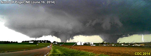
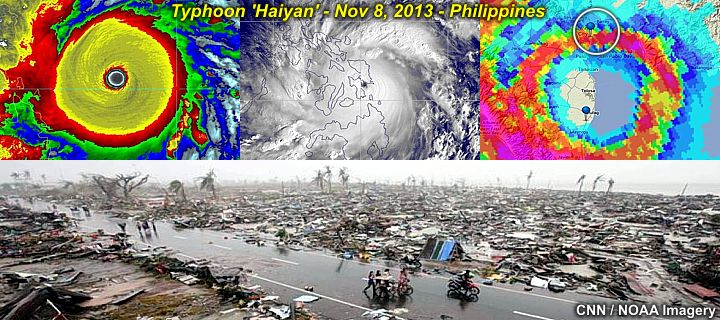
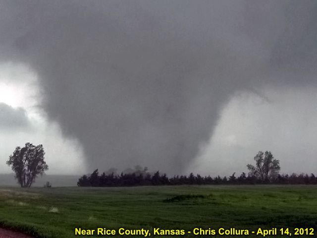
Super typhoon Haiyan carved a path of death and destruction from the central Philippines and into northern Vietnam - With the most devastating effects in Tacloban City and the southeast tip of Samar. About 2,500 people are dead and Tacloban City (with nearly a half a million residents) has been almost completely destroyed after being hit with a massive storm surge and winds gusting around 200 MPH! This is one of the strongest tropical cyclones to make landfall at such intensity. Damage inflicted by the wind alone can be on par to a violent tornado. Afterwards, lack of food and water, as well as massive civilian un-rest, looting, and desperation followed. In the graphic below, three unbelievable satellite and radar (base reflectivity) views of the storm during its first landfall play out. The symmetry (annular, "truck-tire" appearance of the cyclone core area) and intensity (195 MPH winds) make this storm both a terrifying and breathtaking sight.


In the lower part of the image, the main damage inflicted to Tacloban City appears to be disintegration of nearly every structure, including trees (with some trees even showing violent tornado-like damage, such as debarking). How anyone can survive being in something like this is hard to understand (including the group of chasers I know that actually were in the northern part of Tacloban City - Maybe that area of Tacloban City was a bit north of the strongest winds)? Even more alarming was the sense of complacency before the storm. The chase groups there reporting people drinking and playing pool at bars, restaurants still busy, and markets still had all their supplies (no long lines) nor any evacuations. These poor people had no idea what was coming just hours later. All chase teams (iCyclone group, CNN, and Jim Edds) fared OK during the storm, but one member was injured saving the lives of some locals at their battered hotel. All were airlifted out of the area to Cebu City, and eventually made it out of the area. I'm both envy of them, but at the same time, grateful they're OK and hope they don't get mentally perturbed on what they did and / or saw.


The onslaught of typhoons in the western Pacific basin continues. In early November 2013 super typhoon Haiyan (with category-5 winds) blasted its way into the Philippines after skirting just north of the island of Palau, eventually making landfall in Vietnam. Some folks from the iCyclone team (who live in Hong Kong as well as California) and Jim Edds have been intercepting these storms as the tropical Atlantic remains stone-dead. These folks were there for this beast in the Philippines and barely got out afterwards.
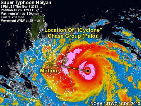
Wind shear and dry air were nowhere to be found in the western Pacific in 2013! In the IR satellite image above, super typhoon Haiyan (with at least 190 MPH winds) is just about to make landfall in the Philippines on November 8, 2013. And YES - The arrow points to the location a group of storm chasers in Tacloban City just about when they were to take a direct-hit with the right-quadrant of this storm! This is one of the strongest tropical cyclones to make landfall in history. If the Atlantic remains quiet the next few years, I will have to consider heading out for these storms myself!

Friday, September 27, 2013

No Hurricanes & My Mom Gone (9/30)

The tropical Atlantic remains a MAJOR and DISGUSTING "disappointment" (from a "chasing" perspective. There were little or NO "Cape Verde" season as we head out of September and into October. Shear and dry air is the norm ... So I ain't got much to say about any hurricane chases this year, and this really is "painful" after losing my mom ...


... My mother, Geraldine Collura, has passed away on Thursday Night, September 12, 2013 at 11:26 PM EDT at age 71. Services will be held at Our Lady of Mercy Church on Military trail in Deerfield Beach, FL on October 3, 2013 (Thursday). She did nothing but put inspiration and guidance throught my childnood up until now. This has been a VERY though month - God bless HER ... And "screw" 'September 2013'!

My Mom Passes Away (9/12)

My mother, Geraldine Collura, has passed away on Thursday Night, September 12, 2013 at 11:26 PM EDT at age 71. Since early June 2010, she fought lung cancer that spread to her brain, causing seizures. She refused any chemotherapy - And radiation / surgery earned her nearly three and a half years of quality time on this planet. During the week of September 1, 2013 she needed chemotherapy as some of the cancer came back. That was the last weekend (after skydiving) when I hugged her and felt a feeling that told me something bad was going to happen ... Leaving in tears. She got a cold later on the following week, and shortly after, on September 6 (that Friday) was in the hospital (North Broward Medical Center in Pompano Beach, FL) with a pneumonia. On Saturday, she slid into a rapid descent with her health, entering a coma and her vitals completely shutting down, starting with the kidneys.


The last words she said was "mom..." (my grandmother). She continued on on life support and had no responses to anything in terms of improvement. Late on Thursday, September 12, she was removed from life support and brought into hospice where she passed away rather quickly, and peacefully, at 11:26 PM local time. This was very difficult - She was the closest person in my life EVER - And now she's gone. I guess God has her in his hands now... I will miss her so much. A memorial web page will be constructed for her as well soon.

TS Andrea (6/6)

The first tropical system of 2013, tropical storm Andrea, was intercepted in NW Florida north of Tampa on June 6, 2013! More information about this chase and many others can be seen in the STORM CHASING section of my web site.


You can go right to the chase log for tropical storm Andrea at the link for it below.

http://www.sky-chaser.com/andrea13.htm

El Reno Violent Tornado Tribute (6/2)

We have lost three fantastic storm chasers and friends of mine and many others - Tim and Paul Samaras, and Carl Young - Perished on Friday, May 31, 2013 in the violent El Reno, Oklahoma tornado while they trying to document it. These three were the cutting-edge of the storm chasing community and our hearts and prayers will always go out to them and their family.


THE CITIES OF MOORE OKLAHOMA AND EL RENO HAVE SUSTAINED SIGNIFICANT TORNADO DAMAGE ... BOTH TORNADOES RATED EF-5 WITH THE EL RENO TORNADO BEING 2.6 MILES WIDE WITH 296 MPH CORE FLOW WINDS ... THREE GREAT CHASERS HAVE BEEN LOST ... PLEASE KEEP OKLAHOMA IN YOUR HEARTS AND PRAYERS


In addition to these three, the El Reno EF-5 tornado claimed more lives in the city itself - This was a dark and tragic day to say the least - With the tornado itself not only rated EF-5 (the strongest on the enhanced Fujita scale of tornadoes), but was an awe inspiring 2.6 miles wide with winds in its core at least 296 MPH! The El Reno, Okhaloma tornado is the widest / largest tornado in US history.

A documentary video of this extreme tornado event, as well as myself being nearly killed in it, has been provided at the link below!

http://www.sky-chaser.com/m14vid2.htm

Chase Expedition 2013 (6/2)

My main yearly chase "expedition" trip to the central USA was from May 18 through June 2 for a full 16 days of storm chasing! Storm activity was extremely active during this period in mid-late May!


Be sure to check my STORM CHASING section for MIDWEST 2013 on this site as the chase trip is completed and my log has been updated. You can also go right to that area by clicking the link that is provided below.

http://www.sky-chaser.com/mwcl2013.htm

Severe Storm Season 2013 (5/9)

The severe weather season of 2013 is upon us and I am getting ready to not only chase local storms in Florida, but head to the Central USA towards late May anticipating an active pattern after a slow start to May 2013!


The picture above shows an anticyclonic funnel cloud, rotating clockwise, over Miami-Dade county in South Florida on the afternoon of May 9, 2013. See my chase logs for 2013 in my STORM CHASING section of this site, plus many others, or jump to the link for it below.

http://www.sky-chaser.com/stplog4.htm

First 2013 Chase (4/10)

The first chase trip of the 2013 season was done from April 6 through the 10 in the central USA. Numerous supercells and some small tornadoes were observed during this trip, especially in Kansas and Colorado from April 7th through the 9th.


A chase log is now ready in my STORM CHASING section of my website under MIDWEST CHASES FOR 2013. A direct link has been provided as well below.

http://www.sky-chaser.com/mwcl2013.htm

"Niagara Faller" Project (3/23)

This was a rather cool attempt to send a GoPro camera, mounted on a custom designed "platform" that was tethered with a 100' rope for retrieval, over the edge of Niagara Falls in late March of 2013. Two GoPro cameras were used in two attempts, with the first one having its case damaged from water impact, but the second one successfully retrieved (barely) after going over the edge.


A section on this has been provided in my OUTDOORS section of this side, and a link for it has been provided below.

http://www.sky-chaser.com/outdoors.htm
Please visit the LINK BELOW for a POV Video of the camera as it reaches the edge ofg the falls!

http://www.sky-chaser.com/outnfpv1.htm

ChaserCon 2013 (2/17)

The National Storm Chaser Convention, or "ChaserCon" in Denver, Colorado was again attended during the weekend of February 15-17, after a 2 week trip to California ... This continued to be another fantastic yearly event that brought in storm chasers from all over the US (and beyond) to collaborate in a three-day event in the mile-high city.


You can also jump right to the area for storm chasing events in 2013, including the storm chaser convention, by clicking the link provided for it below ...

http://www.sky-chaser.com/picnic13.htm.

Sexual Abuse Is Never OK (1/1/2013)

Happy new year to all ... Do you know that child / sexual abuse is REAL - And January is the month where child abuse occurs the most? This is a horiffic and sad part of many lives unfortunate to have to cope with this, and it's after effects.


This is a BIG problem that goes virtually un-noticed until the unfortunate victim suffers many years later. More on this subject, including MY personal experience with such abuse, can be seen at the link below.

http://www.sky-chaser.com/america.htm

Friday, December 21, 2012

Sandy Hook Shooting (12/14)

No words can describe the horrific tragedy that happened at the small Sandy Hook elementary school on December 14, 2012. For someone to do this is beyond words - All we can do is pray for these HIGHLY unfortunate victims and hope for some changes in the way people live their lives with such violent intentions.


I cannot comment anymore on this - Sigh (why KIDS?) - Seeing even our US president crying was a bit too much. Sometimes I really wonder where the fine line between God and the "Devil" really exists. More information on such tragic events, as well as the state of the USA, can be seen at the link below.

http://www.sky-chaser.com/america.htm

Hurricane Season Ends (12/3)

The hurricane season for the 2012 Atlantic basin had ENDED as of November 30, 2012. Meanwhile, far away, the Pacific typhoon season rages on with super Typhoon "Bopha" that slammed ashore in the SE Philippines on December 3, packing 160 MPH sustained winds with higher gusts! The Atlantic hurricane season was a pretty busy season, with a total of 19 named storms (up to the "T" storm "Tony"), and the storms "Isaac" and (ofcourse) "Sandy" being the most devastating.


Now we are officially in the "off season" for storm chasing in this part of the world, with winter setting in, and time for the holidays. Plans are underway for 2013, and the trip for "chasercon" (National Storm Chaser Convention in Colorado) has been already booked for February 2013. Details for the national storm chaser convention can be seen at the link below.

http://www.chasercon.com

Friday, November 23, 2012

Hurricane Sandy Effects (10/28)

Hurricane Sandy was observed (indirectly) during its closest approach to the eastern coastal sections of the state of Florida as well. Some of the destructive marine effects were also observed from this storm. Sandy began as a tropical wave that entered the eastern Caribbean early during the week of October 22, 2012. The storm intensified to a tropical storm, then a hurricane, crossing Jamaica and eastern Cuba as a strong Category one hurricane. The storm passed through the eastern Bahamas as a category two storm before merging with an upper air low around October 25. This caused the hurricane to acquire subtropical characteristics, with a very wide wind field that expanded as the storm winds decreased to category one speeds while off the SE US coast.


The storm produced tropical storm forced winds in Florida during its closest approach, and battered the region with very high waves. The waves, surge, and winds continued to expand in coverage from October 28 onward, with the storm passing east of Cape Hattaras and making a left turn back to the NW as it became a 90 MPH extratropical storm just off New Jersey on October 29. The storm made landfall later that same day causing extensive flooding and wave damage to New England and the eastern Seaboard from Florida to Canada! The storm continued inland, as a post-tropical storm, and caused snow and blizzard conditions in West Virginia areas. Observations of this dangerous storm system were mainly coastal and fringe effects of the winds as it passed Florida. The chase / observation logs for Sandy are also available at the link below.

http://sky-chaser.com/sandy12.htm

Typhoon Sanba (9/15)

With the Atlantic and Eastern Pacific tropical seasons struggling to generate a strong hurricane, a different scenario of violence unfolds a half-a-world away in the Western Pacific with Typhoon "Samba". Formerly a category 5 storm, with 170+ MPH sustained winds (gusts over 205 MPH), the storm slammed ashore during the morning of September 15, 2012 on the small island of Okinawa.


Although far away, I know some storm chasers in that area who were there, mainly James Reynolds who lives in Hong Kong. As of the morning (local time), the eastern portion of Okinawa can be seen looking down through the vertical structure of the clear eye, and I can only wonder what anyone there saw (a "stadium effect"? Fog? No wind?) ... The storm came in at 120 MPH sustained winds - Very impressive indeed!

Hurricane Isaac (8/29)

The image below shows Hurricane Isaac near Lake Ponchatrain just east of New Orleans, Louisiana during the morning of August 29, 2012. The storm caused an estimated 3 billion dollars in damages and at least 44 deaths as it travelled from the eastern Caribbean to the central United States. Maximum winds were up to 80 MPH as a hurricane in Louisiana.


The chase logs on Tropical Storm Isaac in the lower FL Keys on August 26 as well as Hurricane Isaac in the northern Gulf coastal states on August 28-29 are available in the TROPICAL section of the STORM CHASING page on my web site. You can also go right to the section on Isaac via the link for it below.

http://sky-chaser.com/isaac12.htm

Thursday, August 16, 2012

Tropical August Begins (8/6)

The tropical Atlantic is started to get busy as we headed into the second week of (early) August 2012. There were tropical storms Ernesto, Florence, and Gordon. Ernesto became a hurricane near Mexico and the other two remained far out at sea.


Hurricane Ernesto moved into the southern portions of the Yucatan Peninsula as a category one hurricane during the late night of Aug 7-8. The night landfall discouraged any chasing of Ernesto (only chaser Josh M from California went there for it). Ernesto weakened in Mexico, but eventually crossed into the eastern Pacific, forming tropical storm Hector. The other two storms, Florence and Gordon, affected only the open north Atlantic and bothered no one as they remained well out to sea (what hurricane chasers call a "fish storm").

Be sure to keep up to date with any tropical activity in the TROPICS section in my STORM CHASING area of my web site. You can also go right to that area (for tropical activity) via the link for it below.

http://www.sky-chaser.com/tropics.htm

Monday, August 06, 2012

Sad USA Moments (7/21)

Simply going to 'dinner and a movie' became far more dangerous in Colorado this week (as of July 20) than skydiving in the eye of a hurricane (statistically that is)! The PERSON who did this is a pure MONSTER, evil as much as (if not MORE than) a terrorist.


This composite image above shows the flags at my skydiving facility at half mast, overlaid to a stock image of INNOCENT folks at a movie - I HOPE this gets some sort of message across. God bless us all, we all will NEED it. For more information on the SAD situation here in the USA, please see my section on AMERICA, which is also available at the link below (make sure you have the 'Kleenex' handy)!

http://www.sky-chaser.com/america.htm

Tropical Storm "Debby" (6/25)

Tropical storm "Debby" formed in the NE Gulf Of Mexico on June 24. This was the FOURTH named tropical cyclone of the 2012 Atlantic hurricane season. In the image below, the "topside" of TS Debby can be seen from a high-flying commercial airliner (en-route from Toronto to Miami) at nearly 43,000 feet!


In the next image below, the storm can be seen as of June 26 as it was about to cross N Florida as a weak tropical storm / depression.


No intercept was done on the storm because of its weak structure. Debby caused severe flooding in Northern Florida, as well as some tornadoes on June 24 in other parts of the state. 2012 has got off to an extremely busy start, with four named storms before the end of June! Keep track of any tropical systems and hurricanes (and plans to chase them) with via the link for it below.

http://www.sky-chaser.com/tropics.htm

Hurricane "Chris" (6/22)

You would think the THIRD named tropical storm (and the FIRST hurricane) of the 2012 Atlantic hurricane season would have my name (tropical storm / hurricane "Chris") on it and be something to chase? Nope, another storm far from any land and a weak system that churned away in the far north Atlantic, but became a hurricane (briefly) on June 21-22. The 2012 tropical season has got off to a busy start, with two named systems BEFORE June 1 (the official start of the Atlantic hurricane season) forming in the Atlantic basin.


Tropical storm Chris, the third named storm of the season, formed in the north Atlantic on June 19, 2012. It bothered no one as it remained well out to sea (what hurricane chasers call a "fish storm"). The storm managed to reach hurricane Intensity on June 21, making it the first minimal hurricane of the 2012 Atlantic season.

Be sure to keep up to date with any tropical activity in the TROPICS section in my STORM CHASING area of my web site. You can also go right to that area (for tropical activity) via the link for it below.

http://www.sky-chaser.com/tropics.htm

Tuesday, June 12, 2012

Chase Expedition 2012 (6/2)

My main storm chasing trip from May 19 to June 2 is completed. The first couple of days was spent observing the annular eclipse (May 20) in New Mexico and some up-slope storms there a day later. During the following week and a half, I intercepted many supercell storms, even seeing the northern lights in North Dakota on May 22 after chasing there! May 25 in Kansas was un-reachable by me and several other chase teams due to chasing too far in Wisconsin on May 24. This was probably WOULD have been the best chase day of my trip.


My tough lesson learned from this is to give up on anything moving east of the Mississippi River and re-position back west. The trip lasted until June 2, with some of the largest hail I ever seen in my life observed wrapping around a tornado on May 29 in Oklahoma. The trip is completed, and a full chase log (including some picture of the annular eclipse) on it can be seen in my STORM CHASING section for MIDWEST 2012 on my web site. You can also go right to that area by clicking the link that is provided below.

http://www.sky-chaser.com/mwcl2012.htm

Tropical Storm Beryl (5/25)

Just a week after tropical storm Alberto formed off the SE US coast, tropical storm Beryl formed in nearly the same location on May 25, making this a very rare early start (two storms forming BEFORE the official start of the season). Normally, the the official start and end dates for the Atlantic hurricane season of June 1 through November 30.


Tropical storm Beryl ultimately came ashore as a 70 MPH tropical storm at night near Jacksonville, Florida on May 26. I was NOT able to chase this system as it happened in the middle of my 2-week long trip chasing severe storms in the central USA. I have prepared the area on my site for tropical updates, and that are can be seen by clicking the link that is provided below.

http://www.sky-chaser.com/tropics.htm

Annular Solar Eclipse (5/20)

The annular solar eclipse (visible from Asia, across the Pacific, and ending in the SW United States) on May 20, 2012 was observed from near Alburquerque, New Mexico.


The footage on the annular solar eclipse in New Mexico can be seen in the STORM CHASING section of my web site for the central United States in 2012. A direct link to this section has also been provided at the link below (one there, scroll down to the date for MAY 20).

http://www.sky-chaser.com/mwcl2012.htm

To see a video of the eclipse, please visit the link that is provided below.

http://www.sky-chaser.com/m13eclv.htm

Tropical Storm Alberto (5/19)

The 2012 Altantic hurricane season has began early this year with the formation of Tropical Storm "Alberto" on May 19, 2012. This is not uncommon as storms sometimes form outside the official start and end dates for the Atlantic hurricane season of June 1 through November 30 (as those are "only" dates).


Tropical storm Alberto, the first Atlantic storm of 2012, was a minimal and compact tropical storm that churned off the coast of the SE United States. With the early start to the 2012 hurricane season in the Atlantic, I have prepared the area on my site for tropical updates, and that are can be seen by clicking the link that is provided below.

http://www.sky-chaser.com/tropics.htm

Sunday, April 22, 2012

New Buddha Religeon Section (4/21)

I did a project to setup a separate area on my web site dedicated to the Buddha religeon. This is separate from the main pages on my site, and has been placed there as a special religeous project for some voluntary work I have been doing for a local Buddha temple.


This new and special area on this web site can be seen by clicking the link for it below.

http://www.sky-chaser.com/audiobook/index.htm

Tornado Outbreak Chase (4/14)

I have completed a storm chasing trip in the Central USA (Kasnas) from April 13-15, 2012 with numerous tornadoes intercepted on Saturday, April 14, 2012 in Kansas. This setup was a high-risk setup, with deadly tornadoes affecting this area, and a tornado outbreak occurred. In this chase trip, the entire lifecycle of a violent tornado was observed and documented on Saturday, April 14 near Geneseo in Rice County, Kansas - Rated EF-4 and being on the ground for almost an hour.


I have finally completed a full-chase log for this event, and it can be viewed in my on-going section for storm chasing in 2012 that can be seen by clicking the link that is provided below.

http://www.sky-chaser.com/mwcl2012.htm


For a documentary video of the April 14, 2011 extreme storm chasing in Kansas, click the link below!

http://www.sky-chaser.com/m13vid1.htm

Thursday, April 19, 2012

Weekend Chase Planned (4/13)

Storm chasing is heating up and a MAJOR severe weather setup appears to be on tap for the weekend (especially Saturday, April 14) in the central USA. I was able to get tickets and will be flying out on Friday the 13th of April, chase Saturday (the 14th in Kansas), and return on Sunday the 15th!


In the image above, a moderate risk (later upgraded to high) was in place as per the Storm Prediction Center (SPC) on Thursday, April 12.


In the above image, issued by SPC on Friday, April 13 (for Saturday the 14th), a rather scary hish-risk (with 60% hatched probabilities) outlook and chilling text was published as a "high-end life threatening event"! A full-chase log for this event will be available (in my on-going section for storm chasing in 2012) once this first major chase is completed, and that area can be seen by clicking the link that is provided below.

http://www.sky-chaser.com/mwcl2012.htm

Sunday, March 18, 2012

Spring Break Trumps Chasing (3/18)

During a rather active start to the storm chasing season of 2012 ... A rather frustrating and down right agonizing scenario unfolds to a storm chaser stuck in the "corners" of the country. No, it's NOT because of work, school, family, or what not - But for folks living in the middle of the USA - Read no further (this does NOT apply to you).


In the images above, to the right we see a nice setup example (March 18) unfolding across some favorable and fun storm chasing terrain, and on a WEEKEND to boot. The problem NOT visible here is the TIME of the year - SPRING BREAK. Take a look to the left image ... Yes, nearly $1,500 to fly from Fort Lauderdale to Kansas City - Yes, that's REAL. Most other airlines simply don't even HAVE any seats left.

Any my free tickets on SW - Out of the question, they were smart enough to back those out this weekend. This is WHY I normally do not chase storms before mid April. Aside the linear and fast-moving nature of storms and setups, chasing before late April is just impossible if you are not within driving distance of the central USA.

Monday, March 05, 2012

Bad Start For March (3/2)

The beginning of March 2012 was marked by a very tragic and unfortunate tornado outbreak on Friday, March 2. An outbreak of tornadoes, some violent, occurred during the afternoon on March 2 across Alabama, Indiana, and Kentucky. As of March 5, the death toll stands at 39 people, including a 15 month old baby who died a few days later in the hospital after being carried 10 miles by a tornado after both her parents were killed. This is a very sad and unfortunate severe weather event.


In the image above, taken from a Boeing 737 aircraft flying at an altitude of about 39,000 feet, the distant but ominous supercell storm can be seen prominently looming over the 40,000 foot cirrus deck and extending high into the stratosphere. The flight path was over TN / VA at the time, with the view in the picture westward towards I-64. Right about the same time of this subtle image was taken, tornadoes "under" that same cloud were already killing people.

Friday, March 02, 2012

"Cut To The Chase" DVD (3/1)

This is a career-long compilation of some of the most intense moments of storm chasing with footage as far back as 1987 (almost 25 YEARS of storm chasing). The most boring parts have been edited out and this DVD has almost two hours of non-stop high-action video! See every form of extreme weather, from thunderstorms and flooding to hurricanes, tornadoes, and even blizzards! See some of the gripping footage from hurricane chasing projects, including the violent hurricane seasons of 2004 and 2005.


See tornadoes intercepted in just about every corner of the Central US, as well as their devastating aftermath. This DVD just about has it all - And then some! For more information and how to order this DVD, click the image above or the link provided for it BELOW.

http://www.sky-chaser.com/offers13.htm

This is NOT all that is available in my DVD collections for sale ... Be sure to check out the latest DVD production above, as well as many others by visiting my special "offers" page for video documentaries at the link provided BELOW as well.

http://www.sky-chaser.com/offers.htm

ChaserCon 2012 (2/19)

I attended the National Storm Chaser Convention (also known as "ChaserCon") in Denver, Colorado from February 17-19, 2012 ... This continued to be another fantastic yearly event that brought in storm chasers from all over the US (and beyond) to collaborate in a three-day event in the mile-high city. Having everyone together and the way Roger Hill and Tim Samaras ran the operation was an experience second to none.


What an awesome job, from Andy Gabrielson's touching tribute to video night and spotter training, and over 350 attendees to make it all the better. Imagine having dinner with keynote speaker Sean Casey (IMAX film-maker and inventor of the TIV), seeing Tim Marshall's fantastic presentations, and Howie Bluestein just to name a few ... That's what ChaserCon does - Brings us all together to enjoy our passions!

You can also jump right to the area for storm chasing events in 2012, including the storm chaser convention, by clicking the link provided for it below ...

http://www.sky-chaser.com/picnic12.htm

For official information on this event, you can also visit their site at the link below (link may be time sensitive / subject to change without notice) ...

http://www.ChaserCon.com

2012 Everglades Boogie (1/28)

Each year, Skydive Air Adventures outside of Clewiston, Florida (at Airglades airport) hosts the "Boogie over the Everglades" skydiving event on the last weekend of January. This yearly "boogie" (what skydivers call a "special event") draws a crowd of hundreds from many areas of the United States (and some other countries as well) and has everything from specialty jumps (such as high-altitude or jumps from a helicopter) to skydives from multiple aircraft (Skyvan, DH6 Otter, and A-90 King Air) plus a big party with free beer each night of the 3+ day event.


Air Adventures skydiving continues to make this a well-anticipated and well done event year after year. Weather, although predicted to be bad, turned out to be fantastic as well - For pictures / video of this exciting event, please visit my SKYDIVING section of my web site. You can also jump right to the link by clicking link provided below ...

http://www.sky-chaser.com/skydive.htm

Happy New Year 2012 (1/1)

Wishing everyone a happy and safe New Year for 2012 ... Hopefully this year will be another great year for storm chasing and outdoor activities - But hopefully without the horiffic loss of life and property damage we saw in 2011.

Hurricane Season Ends (11/30)

The Atlantic hurricane season runs from June 1 to November 30. Oficially, the 2011 hurricane season is over. To re-cap, the 2011 season was pretty busy, but the only real disastrous storm (affecting land) was Hurricane Irene in late August 2011 (chase log is BELOW for Irene).

http://www.sky-chaser.com/irene11.htm


The rest of the season was burdened by tropical cyclones that were either highly-sheared and / or remained out to sea. All in all, a total of eighteen (18) named storms developed, six (6) of which became hurricanes (three (3) of the hurricanes were major hurricanes). Only one hurricane was intercepted in 2011, that being hurricane Irene. Some other chasers chased hurricane Jova on Mexico's west coast (near Manzanillo) this year as well.

Hurricane Rina (in late October 2011) was another awesome candidate for a chase in Mexico, I actually had tickets booked and all, but the shear ripped Rina apart, and the chase was called off within mere hours of going. The storm was forecasted to hit Mexico during the mid-day hours near Playa Del Carmen / Cozumel as a 120 MPH+ storm, but the shear did not relax, and she came in at night as a 45 MPH dissipating cyclone.


Meanwhile, 2011 lived up to its name as the "year of the tornado" on Nov 7, 2011 in Oklahoma with a late season supercell producing at least six tornadoes some of my fellow chase partners intercepted - Again, the "shear" that never relaxed! For tornadoes in 2011, see the link BELOW as well!

http://www.sky-chaser.com/mwcl2011.htm

Wednesday, November 16, 2011

S Florida EF-2 Tornado (10/18)

An EF-2 tornado affected Sunrise, Florida in Broward County on October 18, 2011 during the late evening - I was chasing this storm and encountered the tornado (barely visible by lightning and power-flashes)!


The storm was a classic supercell that originated over the rural areas of western Miami-Dade county (south of Miccosukee in the Florida Everglades) and moved north and northeast over a two to three hour period through the western sections of Broward and eventually southern Palm Beach counties (where it weakened). The storm produced a destructive tornado, with winds at least 120 MPH (EF-2), from Plantation to Sunrise, just north of I-595 and east of NW 136 avenue.

The tornado was about 150 yards wide, and had a damage path, oriented SSW to NNE, over a mile in length. Some information on this chase can be seen in the STORM CHASING section of this web site (in the "PICTURE Log For 2010 And After Chases" section) or you can go right to that area by clicking the link that is provided below.

http://www.sky-chaser.com/stplog4.htm

Sunday, September 11, 2011

Remembering Sept 11 (9/11)

September 11, 2001 was one of the darkest days in American history. It has been exactly ten (10) years since that fateful day. This year (and every year) is a good time to remember those who lost their lives because of a hostile and down-right cowardly act of terrorism inflicted on the United States by the Al Qaeda / Taliban groups.


Who can forget the heroes that fateful day? To skip to more details on September 11, 2001 and many other subjects about the US, click the link that is provided below.

http://www.sky-chaser.com/america.htm

US Tropical "Protection"? (9/7)

The tropics are very busy as of September 7 ... However, little or no threats exist for the US anytime soon! As of September 7-9, hurricane Katia and tropical storm Maria are churning in the open tropical Atlantic, and NOT expected to affect any land. Tropical storm Nate has formed in the Bay of Campeche, and expected to move into Mainland Mexico later this week. As I mentioned, VERY busy Atlantic tropics, but no threat to the USA at this time.


The graphic above shows the general weather pattern during the week of September 7, 2011. Note (in the graphic above) that despite quite a bit of activity in the Atlantic, the combination of a persistent trough off the US East coast as well as weak high-pressure ridging in the southern Gulf of Mexico, the southeastern and eastern US / northern Gulf regions are sort of in a "quiet zone" (blue area) and nestled in between regions of above-normal risk for tropical cyclones (red areas).

Hurricane Irene (8/28)

My interception and hurricane chase for hurricane "Irene" was on August 26-28 in North Carolina after a coastal observation of its effects in South Florida on the 25th.


Hurricane Irene caused over 10 billion dollars in damages and at least 55 deaths, especially in the mid-atlantic region of the United States. A full chase log and write-up is completed and has been posted in the STORM CHASING section of my web site.

You can go right to the link for the chase log by clicking the link that is provided below.

http://www.sky-chaser.com/irene11.htm

South FL Tornado (8/2)

A small tornado in its late stages was caught on camera late in the afternoon of August 2, 2011 from a 5-10 mile distance. In the image below, the distinct funnel stretched along the gust front can be seen just before the tornado dissipated.


Damage was to some homes (roof torn off) with winds near 90 MPH (EF-1). The view is to the north from near Fort Lauderdale Airport as the storm was weakening and just before the tornado lifted.

Wednesday, July 06, 2011

Tropical Storm Arlene (6/30)

With the main part of the the devastating 2011 tornado season behind us, the focus turns to the Atlantic hurricane season that runs from June 1 through November 30.


Tropical storm "Arlene" was the first named storm of the 2011 Atlantic hurricane season, forming in the Bay of Campeche (SW Gulf of Mexico) on June 28-29 and moving into Mexico as a strong tropical storm on June 30.

Be sure to keep up-to-date with both tropical activity and hurricane chasing operations by checking back here often. I have a page showing tropical activity that can be seen by clicking the link that is provided below.

http://www.sky-chaser.com/tropics.htm