Monday, June 18, 2007

Trip To Canada (6/15 - 6/17)

The weekend of June 15 through June 17 was spent in the Toronto area of Ontario, Canada including a trip to Niagara Falls on the Canadian side then a trip to the city of Toronto. Toronto is located on the northwest side of Lake Ontario and is about an hour from Niagara Falls, which is south of the southwest side of the lake. Niagara falls is a spectacular waterfall system between Lake Erie and Lake Ontario where flows from one lake to the other takes place along the Niagara River. This area is also one of the most heavily visited tourist areas in the world. The city of Toronto is also the most ethnically diverse city in the World.


You can also view this trip as well as many others by checking out the OUTDOORS section of my web site. You can go right to the area for this trip by clicking the link below ...

http://www.sky-chaser.com/outdoors.htm

US / Canada Border Problem (6/15)

I had some problems when crossing from the United States into Canada on June 15 Due to "suspicious contents" found on my laptop computer, brought along for both GPS mapping and internet (email). I was detained and subsequently arrested. I spent about 6 hours at the facility, most of that time in a holding cell (aka: "Jail") in Windsor.

It was not until a special investigator scrutinized my laptop and all contents and deemed there was "nothing there" that was illegal. After this terrifying and seemingly un-fair wait, I was released and apologized to and continued on to my destination, with no more than frustration and a 6-hour delay.


The interesting details on how this unfolded can be seen by clicking the link to it provided below ...

http://www.sky-chaser.com/america.htm

Monday, June 11, 2007

High-Risk Chasing (MN / WI - 6/7)

A second and exciting chase day unfolded on June 7, 2007 through Wisconsin and parts of Minnesota and Illinois which was part of my chase trip to the US Great Plains and Midwest was during the period from June 5 through June 10, 2007. On June 7 a high-risk and rough chase landed myself with three tornadic supercell storms and my first experience seeing what GIGANTIC hail can do to a small Midwestern town that was hit by a tornado on one side and the hail on the other!


The chase log for the June 7 storm chase is also online and can be seen by clicking the link to it provided below ...

http://www.sky-chaser.com/mwcl2007.htm

Tornado In South Dakota (6/6)

A long-shot chase trip to the US Great Plains and Midwest was done during the period from June 5 through June 10, 2007. On June 6 a tornadic supercell storm was intercepted near Wanblee, South Dakota. This was the first sucessful chase day of the June 5-10 chase trip.


The chase log for the June 6 storm chase is also online and can be seen by clicking the link to it provided below ...

http://www.sky-chaser.com/mwcl2007.htm

Tropical Storm Barry (FL - June 1-2)

Tropical storm Barry decided to affect Florida with winds and torrential rains just as I was doing a routine visit there from Ohio, where I work (I live and have a house in Florida). The flight into Fort Lauderdale was pretty much rough-and-tumble turbulence through the feeder-bands (left picture) of TS Barry! In the center and right pictures, large waves, wind and rain affect Deefield Beach fishing pier. TS Barry weakened a day later on June 2 near Tampa, FL without much in the way of wind, but gave FL some much needed rains.


There is a small chase log for this storm, adn you can see it by clicking the link to it provided below ...

http://www.sky-chaser.com/ba07.htm

Storm Chase Bust (MN / WI - 5/26)

A chase trip was attempted on a potential setup near the tri-state region of Iowa / Wisconsin / Minnesota and did not really pan out as well as expected due to lack of instability. Such "busts" do happen, and are a part of chasing - Like going out fishing and not catching anything good - Same "hit" or "miss" scenario.


The chase log for this attempted storm chase is also online and can be seen by clicking the link to it provided below ...

http://www.sky-chaser.com/mwcl2007.htm

Friday, May 25, 2007

SVR Storms (TX, OK, & KS - 5/23)

A special trip was made during the mid-week of May 22-24 for a chase day in the Texas / Oklahoma panhandle area on May 23, 2007. During this special "spot-chase", a tornadic supercell was intercepted near Laverne, Oklahoma during the late afternoon of 5-23-2007 and a monster HP supercell storm later on farther southwest near Lipscomb, Texas!


This chase started by Leaving Dayton, OH near 9 PM via a flight to Kansas City, MO arriving at 11:30 PM. Picked up rental vehicle then headed west to Abilene, KS for the night. May 23 was a full chase day in the Texas and Oklahoma Panhandle regions. An all night drive back to Kansas City, MO ended the chase on May 24 with a 5:40 AM flight back to Dayton, OH at 9:40 AM - Yawn!!

The full chase log is now online and can be seen by clicking the link to it provided below ...

http://www.sky-chaser.com/mwcl2007.htm

Monday, May 21, 2007

Kings Island Theme Park (5/20)

Kings Island is another theme park in Ohio (near Cincinnati). This is another place for the roller coaster enthusiast and has many high-thrill attractions. The Beast is the longest wooden roller coaster in the world, with a ride time of nearly five minutes, try it - If you dare!


You can check out some on-ride footage of these amazing coasters as well as other extreme rides at Kings Island by checking out the link provided below ...

http://www.sky-chaser.com/coasters.htm#KINGSI

Dayton Hamfest (5/19)

The Dayton Hamfest (or Hamvention) is a yearly event held at the Hara Arena in Dayton Ohio each year. It receives world wide attention, and hard-core HAM radio operators, along with "casual" HAMs, and even their friends and families, come each year to it. With myself living and working in Dayton, Ohio just blocks away from the Hara Arena, I attended this event on May 19, 2007.


I put many pictures and coverage of this event in the STORM CHASING PICNICS AND EVENTS section of this web site. You can see more by checking out the link provided below ...

http://www.sky-chaser.com/picnic07.htm#CEDARPT

Northern Indiana Chase (5/15)

A round of severe thunderstorms occurred in northern Indiana and parts of Ohio on May 15, 2007. This promped another severe weather chase inwhich two nice gustnadoes (tornado-like vortices created in strong gust-fronts) were observed with an intense squall line west of Fort Wayne, Indiana during the afternoon as well as hail and high winds in Ohio in the late evening towards midnight.


You can also check the status on any storm chases for 2007 in the central USA by clicking the LINK provided below - This should take you to the special section for any storms chased in the central USA during 2007...

http://www.sky-chaser.com/mwcl2007.htm

Monday, May 14, 2007

Storm Chasing Slows In May 2007

The image shown below is the airflow at high altitude over the United States - This is why our chase plans have resorted to "spot chasing" and no long chase "expeditions" ... The "Omega" shaped airflow is due to a BLOCKING RIDGE pattern that has been over the central USA since the first week in May 2007 and can last as long as the entire month of May 2007! These so called "death ridges" can effectively shut-down storm chasing operations in the central US.


Lucky were those who have been out there before the first part of May when the pattern was busy, now it's not, so storm chasing is lame as it was during the "past 2 Mays". We are waiting for this pattern to break so that chasing can resume. On the flip-side, this "quiet pattern" does, however come as a fantastic relief and reprieve to those unfortunate tornado victims of the start of the 2007 storm season, especially those of Greensburg, KS.

Cedar Point Theme Park (5/12)

Cedar Point is a theme park on a penninsula that juts out into Lake Erie in Northern Ohio near Sandusky. Opening day for the season was May 12, 2007 and very busy with long waits and lines, as you can imagine. This place is noted for at least 17 roller coasters plus many other high-thrill attractions.


Many roller coasters here have broken records for their sheer height (called "giga-coasters" or even "strata-coasters"). One of the most notable examples of a "strata-coaster" is the "Top Thrill Dragster" attraction, with a height of 420 feet and a gut-wrenching 10,000 horsepower hydraulic launch system capeable of accelerating an 18 passenger train from 0 to 120 MPH in under 4 seconds!

This Is YOUR Face At 5 Gs - Any Questions?

You can check out some on-ride footage of this high-G monster as well as many others at Cedar Point by checking out the link provided below ...

http://www.sky-chaser.com/coasters.htm#CEDARPT

Tuesday, May 08, 2007

Greensburg, KS Destroyed (5/4)

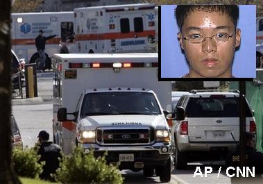
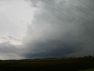
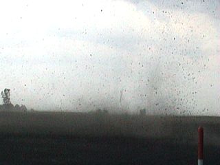
A very devastating and large tornado struck Greensburg, Kansas during the early evening of May 4, 2007 and destroyed most of the town and killing at least a dozen people. This is the kind of disaster one may not want to witness, no matter how much he or she may like seeing storms.


The picture above was taken by fellow chaser Dan Robinson with STORMHIGHWAY.COM as I was not with him or out chasing in that area. The tornado, called a WEDGE, is about a mile and a half wide and just about to hopelessly take out Greensburg as this picture was taken. The tornado was rated EF-5, the highest on the enhanced Fujita scale, with winds at least 205 MPH extending across a path nearly 2 miles wide.

You can also visit Dan Robinson's great web site, at STORMHIGHWAY.COM by clicking the picture above, or by clicking the link provided below...

http://www.stormhighway.com
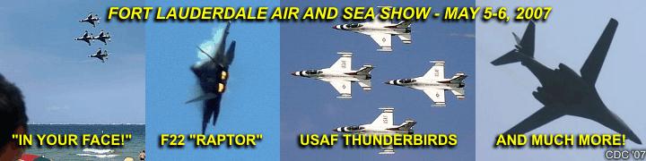
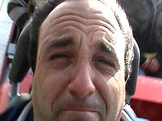
Remembering Virginia Tech

Our heart and sorrow goes out to all the victims, friends, and families, plus anyone who has been affected by the senseless and tragic shooting spree that took place at Virginia Tech the day on Monday, April 16 of 2007. This is another horrific example of what kinds of roads people may be headed down in our world today! This is indeed the dark-side of what we all see in the NEWS.


This horiffic event should not have happened, not here in the USA at least. A special tribute section has been set up for it in my area on AMERICA, with more details. Please click the link below to see it...

http://www.sky-chaser.com/america.htm

SVR Storms (S Florida - 5/6)

May 6, 2007 presented a round of severe thunderstorms in south Florida. The storms were caused by a developing low pressure region to the northeast of the area combined with sea-breeze boundaries and a low-pressure trough. Some supercell storms developed by late afternoon, and moved south across south Florida. One supercell storm in Broward County produced a small tornado west of the populated areas.


I was able to intercept some severe weather down in Broward County, south Florida ... For more information with pictures on this supercell storm, check out the link below in my section on storm chasing for 2007 (other storm chases)...

http://www.sky-chaser.com/stlog.htm

For pictures on this storm plus others for 2007 (other chase log pictures), check out the link below...

http://www.sky-chaser.com/stplog3.htm

FTL Air And Sea Show (May 5-6)

The 2007 Mc Donald's Air And Sea Show took place on the weekend of May 5-6, 2007 at the end of Fleet Week. This is a yearly event, since the mid 1990's (originally sponsered by Shell), where over a million people flock to Fort Lauderdale beach to see boats and aircraft of many types and capabilities. This year the Air Force Thunderbirds demonstration team and F22 "Raptor" were some of the biggest stars of the show.


You can check out more about this incredible event by clicking my link on airshow coverage by clicking the LINK provided below - This should take you to the special section for ALL my footage on airshows...

http://www.sky-chaser.com/airshow.htm

Wednesday, May 02, 2007

Northern Ohio Chase (5/1)

Tuesday, May 1, 2007 was an interesting chase in the northern Ohio area where anything from supercells to hail and flash flooding was observed. My STORM CHASING pictures and chase logs have been updated as well for this chase. Click the pictures above to go right to the updated chase log for May 1.


You can also check the status on any storm chases for 2007 in the central USA by clicking the LINK provided below - This should take you to the special section for any storms chased in the central USA during 2007...

http://www.sky-chaser.com/mwcl2007.htm

Soaring Over Illinois (4/28)

Nothing is more incredible than experiencing flight on a sailplane (glider)! Towed into the air to about a mile above the ground, a sailplane has NO ENGINE, and attempts to use THERMALS (rising air) to gain altitude. Piloting a glider is a skill and art, far different than powered aircraft. Using the thermals to gain altitude brings a new respect for "renewable energy" as no fuel is consumed by sailplanes!


Check out the pictures taken at Windy-City Soaring gliding club in Hinkley, Illinois plus much more incredible footage of flying by checking out my secton on FLYING on the Sky-chaser site, or you can click the link below to jump right to it!

http://www.sky-chaser.com/flying.htm

No World Free-Fall 2007 ;-(

A suprise thunderstorm with small hail from 1/4" to 1/2" hit parts of Dayton, Ohio on April 14, 2007 in an environment you would last expect to see such weather. This hail fell on the backside of a strong low pressure system with surface temperatures in the upper 30's and light rain mixing with snow.


The 2007 World Free Fall Convention has been CANCELLED this year! This is to the disappointment of many skydivers from all over the world who look forward to this event each year. For 17 years, this has been a yearly event, originally in Quincy, IL then in Rantoul, IL. I was planning to attend this event once again this year of 2007, and after hearing this news, was more than happy I did so last year in 2006! There is no official news on why this event was cancelled, but you can read about it more by clicking the picture above!

SVR Storms (Indiana - 4/26)

Activity is heating up through out tornado alley and a new approach is in the works for this years storm chasing. There will not be a dedicated "chase expedition" for this year. Instead, only major setups for tornadoes and severe weather will be tackled on a chase-by-day basis. No planning for a trip in May and all the activity in June. No more "sitting" under Rex blocks and ridges for 2-3 weeks. No huge expenses for extended stays and gas. Since just setups will be targeted, a shorter trip JUST for that setup will be the order, with a MUCH greater chance of success, and less time off work to boot!


Some severe weather and even a MINI HP supercell was encountered on April 26, 2007 in eastern Indiana near Union County as a system of thunderstorms passed through the area. A local "backyard" chase was done on these storms and pictures / chase logs have been updated as well.

All such chases in the central USA will be logged in the STORM CHASING section of this site under 2007 CHASES IN THE CENTRAL UNITED STATES, or you can click the link below to jump right to it!

http://www.sky-chaser.com/mwcl2007.htm