Monday, March 24, 2008

Last Winter Storm? (3/21)

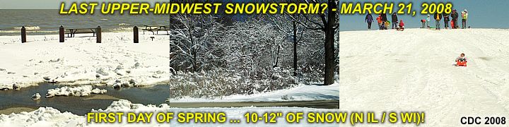
Spring has arrived in Chicago as og Friday, March 21, 2008 but that does not mean winter is over just yet. A late-season snow-storm struck the northern Midwestern US leaving a narrow blanket of snow from Minnesota through Wisconsin / Illinois and into Michigan. The snow "swath" in Illinois was confined to the extreme northern portions of the state (north of Chicago) and into southern Wisconsin, where 10 to 12" of snow fell.


The snow "swath" was so distinct that the northern portions of Chicago had 6 to 8" while the southern portions saw only a light dusting! In the pictures above, a beautiful winter scene plays out in Chicago's northside and far-northern suberbs after the storm departs and sun comes out. The Chicago area has had one of the worst winters in about 30 years for 2008.

Tuesday, March 18, 2008

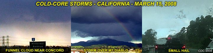
California Cold-Core Storms (3/15)

A region of vorticity aloft, accompanied by very cold air aloft, allowed storms to develop in the otherwise stable cool Pacific air mass. Winds were from the northwest with temperatures in the 60's.


The picture above shows some intense thunderstorms, including a cold-air funnel and small hail, in a place unlikely for storms - Central California! These storms were encountered while in the central California area for a weekend with friends.

Be sure to check out this event, along with many others for 2008 in the storm chasing area of my website, or click the link below to go right to it...

http://www.sky-chaser.com/mwcl2008.htm

Monday, March 10, 2008

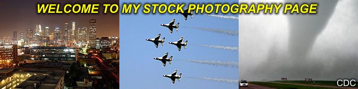
Stock-Photo Page Added (3/1)

I am now pleased to offer high-quality and high-resolution digital imagery of nature, storms, urban, and many other compositions for delivery via postal mail or email delivery with easy payment options, including Paypal!


All images for sale are royalty free and unlimited usage at the flat-rate of $10 per image. Delivery via email is free ($10.00 total)> Shipping via USPS is in the form of an 8" x 10" image centered on glossy 8.5" x 11" photo stock, and is $3.00 extra ($13.00 total).

For more details, please check the special OFFERS section of this site and look for the digital photography link, or simply click the link below to go right to that section...

http://www.sky-chaser.com/offers10.htm

Tuesday, February 26, 2008

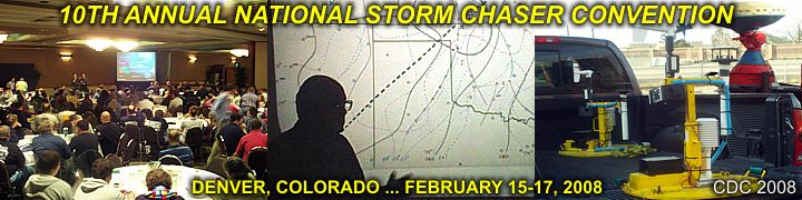
Nat'l Storm Chaser Convention (2/16)

The National Storm Chaser Convention (NSSC) was from February 15 to 17, 2008 at the Raddison in Aurora, Colorado and was excellent with a great turnout! Close to 300 storm chasers and their associates attended this event.


The agenda included excellent presentations ranging from photography, storm dynamics, forecasting, even high-speed lightning photography by Tim Samaras and a wonderful presentation of US Plains history by Dave Hoadley to name a few.

Special thanks to Roger Hill and Tim Samaras for such great planning and organizing this event. More pictures can be seen in the storm chasing events for 2008 link provided below...

www.sky-chaser.com/picnic08.htm

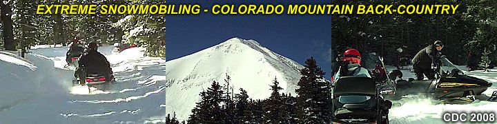
Extreme Snow Mobiling (2/15)

What a time to spend the day before the start of the Colorado National Storm Chasers Convention - Extreme snow-mobiling! My group of storm chasing friends and associates took a back-country snow mobiling tour deep in the Colorado Rockies and along the top of the Continental Divide and at elevations approaching 13,000 feet above sea level!


This is by far the best way to see some of the best mountains in North America, and the weather was sunny, clear, and cold - Permitting a line of sight exceeeding 160 miles! The snow pack was as high as 400 inches in some high-altitude mountain areas - That's over 30 feet!

Click the link provided below for more pictures and information ...

www.sky-chaser.com/skydive.htm

Tuesday, February 12, 2008

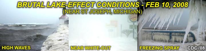
Brutal Lake-Effect Snow (2/10)

February 10, 2008 brought a nasty Canadian "Alberta Clipper" cold front across the north and Great Lakes region with temperatures near -10 degrees F below and wind-chills in the -30's ...


... So where did I go? The beach! See the brutal lake-effect snow in Saint Joseph, Michigan along with huge waves and 50-MPH winds during the morning of February, 10 at the link provided below...

www.sky-chaser.com/winter.htm

Thursday, February 07, 2008

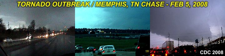
"Super-Tuesday Outbreak" Chase (2/5)

A significant severe weather / killer tornado outbreak took place in the south-central US on February 5, 2008. This was called the "Super Tuesday Tornado Outbreak", and killed at least 59 people. Particularly hard-hit was the western Tennessee area (near Memphis) and parts of Arkansas where deadly and destructive tornadoes hit during the afternoon and evening.


- STORM CHASING IS NEVER PLEASANT WHEN PEOPLE ARE BEING HURT -
- GOD BLESS ALL THOSE AFFECTED BY THIS TORNADO OUTBREAK -

I was able to chase and tackled this difficult and extremely dangerous setup with a trip from Chicago to Memphis (500 miles each way)! There is a full report on this event and is available at the link below...

www.sky-chaser.com/mwcl2008.htm

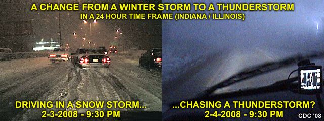
Snowstorm Then "ThunderFog" (2/4)

Amazing to see a snow storm on 2-3 in Illinois, then, just 24 hours later, I am on a storm off I-65 in Lake County, Indiana chasing a thunderstorm with frequent lightning, small hail, and 50-MPH winds!


In the pictures above, we can see cloud-to-ground (CG) lightning strike to the far right, with blowing FOG ... Yes - That white on the ground to the left of that picture is snow. In the left picture, a car spins out and hits someone in front of me in a snow storm with 4" on I-94 / I-80.

You can also check out a chase report for the thunderstorms on 2-4 at the link below...

www.sky-chaser.com/mwcl2008.htm

Monday, February 04, 2008

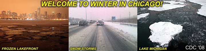
Winter Weather! (2/2)

The weather in Chicago this year of 2008 has been anything but boring. One day it's extremely cold and sunny, the next day its 50 degrees and foggy, then a line of thunderstorms moves through, and by that evening, a 6-12" snow storm hits!


In the pictures above, parts of Lake Michigan are frozen solid. The middle picture shows a nasty commute to work in a snow storm - Good for kids, who were off from school - But not for people driving in it. The picture to the right shows small icebergs floating in Lake Michigan. Actually, they are simply chunks of pack-ice that break apart when lake ice shifts due to strong winds.

Frigid temperatures allow even a large body of water such as the Great Lakes to develop ice.

Saturday, February 02, 2008

Skydiving And An L-39 Jet (1/26)

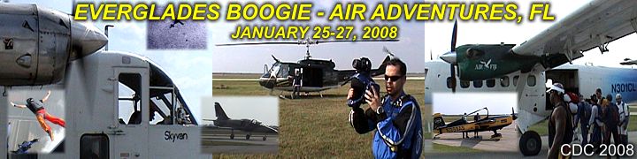
I attended the Everglades Skydiving Boogie event held at Air Adventures in Clewiston, Florida during the weekend of January 25-27, 2008! This was an awesome skydiving event with at least four jump aircraft (Balloons, Helicopter, Super Otters, and Skyvan) and had a tremendous turnout and good weather most of the time.


The event even allowed both skydivers and non-skydivers to get a ride in two incredible aerobatic aircraft, an Extra 300 or an L-39 jet fighter! You can check out this event in the SKYDIVE section of this web-site or simply click the link provided below...

www.sky-chaser.com/skydive.htm

For my second time in my life, I was able to fly aboard an L-39 fighter jet at Airglades Airport in Clewiston, Florida during the Everglades Skydiving Boogie 2008! On this flight, a unique POV concept was used, and the video is there to prove it! The video is finished, and is also available at the link provided for it below.


Several pictures of the flight (along with those from a similar flight at WFFC in 2006) have been posted in the FLYING section of this web site. See what it's like to buzz clouds and come within 15 feet of the ground at over 300-knots while nearly passing out with over 6 G's of force pressing on you!

For the FLYING section, you can click the link provided below...

www.sky-chaser.com/flying.htm

For a video clip of the L-39 flight, you can also click the link provided below...

www.sky-chaser.com/l39vid.htm
Chasing Lake-Effect Snow (1/19)

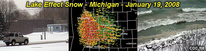
An interesting observation was done to pass some frigid "winter" time on January 19, 2008. This involved a lake effect snow event in Michigan, about an hour's drive from where I am staying in Chicago's south side. With a Canadian / Arctic blast, temperatures in Chicago struggled to get above zero degrees F on Jan 19th, with clear and sunny skies.


In Michigan, near Saint Joseph, conditions were a mere 10 degrees warmer, with blowing and drifting snow racing on-shore from Lake Michigan in a scene very reminiscent of a "frozen tropical storm"!

You can check out such extreme winter weather in the WINTER section of the storm chasing area of this web-site, or simply click the link provided below...

www.sky-chaser.com/winter.htm

Chicago Severe Storms (1/7)

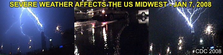
A rather unusual (for January that is) weather setup unfolded across the US Midwest on January 7, 2007 ... The pictures above wer taken as the storm complex (strong and severe thunderstorms) moved through the Chicago area after dark. The Sears tower antenna spires were struck several times! Even more interesting, the picture to the far right shows a rare positive polarity strike - common with winter thunderstorms - branching upwards into the sky.


Apart from lightning and flooding in Chicago, the storm system produced severe storms from Oklahoma to Wisconsin, including damaging tornadoes - most likely the earliest to occur in any given season.

Hard to imagine that just 5 days prior, these same regions were blanketed with snow and frigid arctic air! Chicago had temperatures in the 60's before the storms rolled in.

You can also check out a chase report for this event at the link below...

www.sky-chaser.com/mwcl2008.htm

Friday, January 04, 2008

Midwestern Winter Storm (1/1)

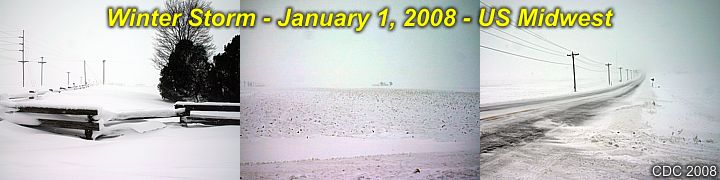
Driving up from Florida to Chicago was easy ... The first 90% of the trip - That is! I was able to leave Fort Lauderdale early morning on December 31, 2007 and drive straight through (little traffic and great weather) to Indianapolis, IN where I spend the night. The short leg from Indianapolis to Chicago was right into blizzard conditions, with gale-forced winds, moderate snow, and drifting snow. The Interstate was OK, but the country roads, shown above, were very dangerous.


About 3 to 9 inches of snow was observed, depending where you were from NW Indiana into Illinois. Temperatures were in the 20's then dropped to near 0 degrees F behind the storm system. A powerful winter storm moving across the great lakes caused the snow and wind.

See more details on this storm and more exciting winter weather at it's worst by clicking the link provided below...

www.sky-chaser.com/winter.htm

Thursday, December 27, 2007

Off To Chicago (12/31)

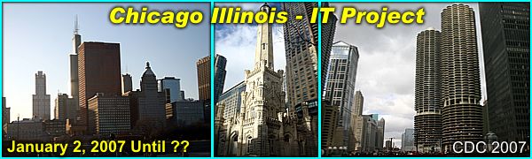
Once again, spending 3-4 months or so on a computer project with the University of Chicago starting January 2, 2007 ... Most likely not many storms to chase there - It's the dead of winter and there will, however, be lots of snow, ice, and cold windy weather!


The programming (PICK / MV) project is temporary and should be done in the time-frame shown (or less if something else locally in FL comes up).

Post-Season TS "Olga" (12/12)

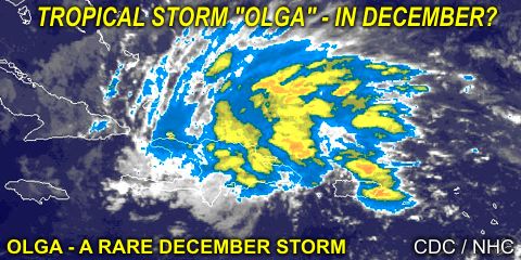
Just when we think the 2007 Atlantic Hurricane Season is finished a new tropical storm forms - In DECEMBER - Tropical Storm "Olga"! December storms are rare, but do happen occasionally. This one is interesting as it affected the Caribbean as it headed to the west, an unusual direction for this time of year, due to abnormally strong high-pressure to its north.


The storm headed west and continued weakening as it headed into a region of higher vertical shear / dry air in the western Caribbean - Typical in the tropics in December. The storm eventually weakened into a remnant low and reached the Yucatan Penninsula as no more than a swirl of low clouds before dissipation.

Landspout Tornado (12/8)

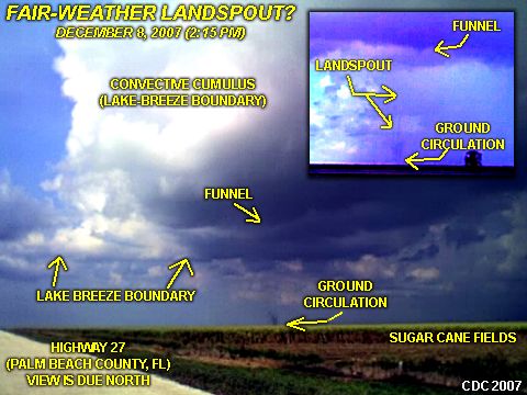
Small landspout tornado observed in Palm beach County near South Bay east of Highway 27 in Florida! This was a small tornado (most likely EF-0) that formed along the lake-breeze boundary and under low-topped convective cells.


The landspout lasted about 10 minutes and weakened before reaching Highway 27. In the picture, a clear ground circulation is visible and funnel above it on the parent convective shower - A tornado is a "tornado" - And to much amazement on such a fair-weather day!

Monday, November 19, 2007

Alcatraz Island (CA 11/19)

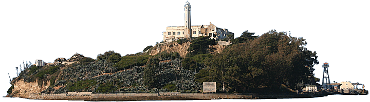
See the island of Alcatraz and US Penitentiary in the San Francisco Bay! This island was home to a federal prison from 1934 through 1963.


You can check out the link provided below for more information on the wonders of Alcatraz...

www.sky-chaser.com/alcatraz.htm

Wednesday, October 31, 2007

Tropical Storm Noel (FL - 10/31)

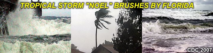
Tropical storm Noel passed east of Florida on Halloween 2007 (October 31) but affected the east coast of southern Florida with very high waves and winds well over gale (tropical storm) forced. Check out the footage of this rather weak but interesting tropical system.


You can check out the link provided below for more information on this observation / coastal chase of tropical storm Noel...

www.sky-chaser.com/noel07.htm

Long Island NY (9/25)

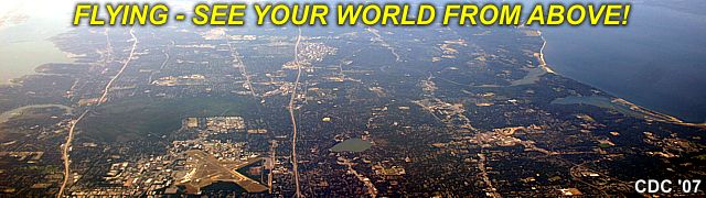
Any hint on what the picture below is? Where is it? This is central Long Island, New York, viewed from an altitude of about 23,000 feet on a warm and clear Indian Summer day. The importance of this place is that it's where I grew up, went to school, and lived until I was 16 years old. If you look closely, you can make out a small lake just below the center of the image, that's Lake Ronkonkoma, and my surrounding home-town.


Flying gives one a whole new perspective on our world and where we live. Whether you are an avid pilot, or weary traveler, the view outside the window on that delayed flight just might give you a whole new way one can look at (and appreciate) our world miles below. I have a large collection of flying footage and pictures. You can click the link below to check out my section on flying ...

http://www.sky-chaser.com/flying.htm

Wednesday, September 12, 2007

Remembering 9-11-2001 (9/11)

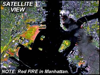
REMEMBERING SEPTEMBER 11, 2001 ... It has been 6 years since America was attacked by terrorists on that fateful day of September 11, 2001. A good friend of mine described over lunch his horror of seeing the collapse of the World Trade Center from New Jersey 6 years ago on that fateful day.


In rememberance, please visit the link below to remember those lost as we will NOT forget all lost on that terrible day...

http://www.sky-chaser.com/america.htm