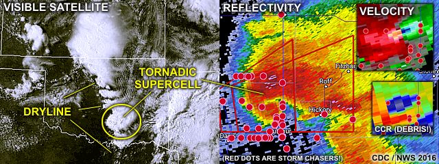
The impressive radar presentation (right image) of this storm shows an extremely powerful mesocyclone (velocity is the upper-right inset, and correlation-coefficient in the lower-right inset - Prominently showing the grey-blue "debris" ball) as this storm was producing a potentially violent wedge tornado. The satellite image to the left shows the supercells in Oklahoma firing along the dryline (annotated), including the one in the radar images (circled). Impressive to say the least!
Please check my chase logs in the STORM CHASING section of this web-site under MIDWEST 2016 for this and many more chases in 2016. You can also click the link below to jump right to the section for storm chasing in 2016 in the central USA...
http://www.sky-chaser.com/mwcl2016.htm
No comments:
Post a Comment