Saturday, September 20, 2008

Hurricane Ike (9/12 - 9/13)

Hurricane Ike hit Galveston, Texas on September 12-13, 2008 and - again - my chase partner and I were there! Landfall packed winds near 110-MPH with devastation, storm-surge, and even fires.


The chase log for my hurricane Ike intercept in SE coastal Texas / Galveston Island is available in the STORM CHASING section of this web site. You can also click the link provided below to check the section for hurricane Ike ...

http://www.sky-chaser.com/ike08.htm

Saturday, September 06, 2008

Hurricane Gustav (9/1)

Hurricane Gustav hit SW Louisiana on September 1, 2008 and my chase group and I were there! Landfall packed winds near 110-MPH with devastation just 3-years after hurricane Katrina.


The chase log for our hurricane Gustav intercept in the northern Gulf Coast is available in the STORM CHASING section of this web site. You can also click the link provided below to check the section for hurricane Gustav ...

http://www.sky-chaser.com/gustav08.htm

Flying Over TS Fay (8/22)

The image below is a panoramic view of the circulation center of Fay, taken on August 22, viewed from a commercial jet aircraft flying over the storm at about 38,000 feet!


The picture above was when tropical storm Fay was inland over North and Central Florida, and being over-flown by a commercial airliner enroute from Fort Lauderdale to Chicago.

More information on tropical storm Fay can be seen at the link below ...

http://www.sky-chaser.com/fay08.htm

Tropical Storm Fay (8/19)

Tropical storm Fay was intercepted in SW Florida on August 19, 2008. Tropical storm Fay was an interesting storm because it made MANY landfalls (2 in the Caribbean, and 4 in Florida alone) and had a very strange track from August 15 through August 24. In Florida, it made landfall near Key West, then on the SW Florida coast, then re-emerged into the ocean near Cape Canaveral, only to make a third landfall near Daytona Beach, cross the state, then re-emerge over the NE Gulf of Mexico, and make a final landfall near the FL Panhandle.


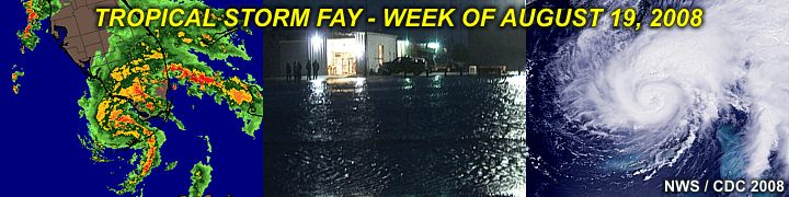
The storm packed winds up to 65-MPH and dumped over 20 inches of rain in less than a weeks time during its chaotic path across the state of Florida. You can check out my full chase log on Fay by clicking the link provided below (for my STORM CHASING section) ...

http://www.sky-chaser.com/fay08.htm

Hurricane Dolly (7/23)

The Atlantic hurricane season of 2008 came alive on July 23 with a vengence as Hurricane Dolly, the first hurricane to strike the US in 2008, came ashore in Texas just north of the Mexico / US border at about 2 PM CDT packing winds of 100-MPH. This is a category-2 storm on the Saffir-Simpson scale.


I was not able to intercept this storm (unfortunately) but you can check out the tropical season of 2008 by a special section called "TROPICS" in the STORM CHASING area of this site. The tropics will continually be monitored in 2008 for any activity to study or even intercept!

Click the link below to jump right to my section on tropical weather ...

http://www.sky-chaser.com/tropics.htm

Liquid-Sky Boogie (7/19)

The "Liquid-Sky" skydiving boogie (special event) was from July 18-20 in Clewiston, Florida at Air Adventures skydiving. This event included some hot summer skydiving fun, as well as aerobatic rides!


You can check the SKYDIVING and FLYING sections of this site for pictures and details on this fun event. These pictures can also be seen by clicking the links provided below.

Below is the link for skydiving events, such as this one ...

http://www.sky-chaser.com/skydive.htm

Below is the link to my FLYING section, including aerobatics ...

http://www.sky-chaser.com/flying.htm