Thursday, August 07, 2014

Hurricane "Arthur" NC Chase (7/4)

Hurricane "Arthur" was the first named storm of the 2014 Atlantic hurricane season. The storm was intercepted in North Carolina from the Morehead City / Atlantic Beach area late on July 3 then again before dawn on the outer banks south of Nags Head, NC. The storm was a category 2 hurricane with winds of 100 MPH. This was also the first hurricane chase since 2012.


I now have a full chase log for this intercept, and it is available in the STORM CHASING section of my site (in the tropical cyclone section). You can jump right to the chase log via the link for it below.

http://www.sky-chaser.com/arthur14.htm

A video of this hurricane chase is also available and can be viewed in the log for this chase, or you can jump right to it via the link.

http://www.sky-chaser.com/ar14vid.htm

Nebraska "Twin" Tornadoes (6/16)

The true and brutal "violence" of weather in the Central United States made its ugly mark on June 16, 2014 near Pilger, Nebraska with a series of multiple tornadoes (some violent). Please pray for all who were affected by this recent disaster. The image below shows two violent tornadoes close to one another, each of similar size and intensity, with lightning and a destroyed farmstead in the foreground.


A chase trip was done from June 13 to June 17, with chases in Iowa, Kansas, Oklahoma, and most importantly, Nebraska. A full chase log for this trip can be viewed at the link for it below!

http://www.sky-chaser.com/mwcl2014.htm

For a video of the incredible Nebraska chase for June 16, please check out the link below.

http://www.sky-chaser.com/m15vid1.htm

Friday, July 11, 2014

Moderate-Risk "Mini" Chase (6/4)

Another chase trip was done again for a moderate to high risk "spot" chase in Nebraska mainly on June 3, with a departure from Chicago on June 2 and return June 4. Some HP supercells and a couple weak tornadoes were observed using my own chase vehicle for this trip. The chase log is also available in my STORM CHASING section of this site (under MIDWEST 2014).

Please click the link Below for more information on the chase details for June 2-4, 2014!

http://www.sky-chaser.com/mwcl2014.htm

Shortened Chase "Expedition" (5/23)

Chase "expedition" 2014 was originally scheduled from May 18 through June 1, 2014 but was cut short as of May 23. The pattern was more active during this period with supercells and a couple small tornadoes observed in and around Colorado. I used my own chase vehicle for this trip, and a full chase log is now available in my STORM CHASING section of this site (under MIDWEST 2014).

Please click the link Below for more information on the chase details for May 18-23, 2014!

http://www.sky-chaser.com/mwcl2014.htm

Storm Chase Trip Completed (4/28)

From April 25 through April 28, I was storm chasing in the Central USA / US Great Plains and flew out of Chicago to Kansas City. I was chasing mainly in Oklahoma and Kansas on Saturday April 26 with a cap bust (no storms formed anywhere outside of limited areas in Texas) and Sunday April 27 being a failed moderate to high-risk chase day in Missouri and Arkansas (bad positioning and later bad terrain). A violent tornado did form in Arkansas and caused death and destruction there in the early evening of the 27th (Mayflower, Arkansas) ... God bless the victims there. I returned to Chicago late Monday morning on April 28.

Please click the link Below for more information on the chase details for April 25-28, 2014!

http://www.sky-chaser.com/mwcl2014.htm

First Storm Chases (4/3 & 4/12)

The first storm chase of 2014 was done on April 3, 2014 in central Missouri with an HP supercell storm intercepted. Another chase in Illinois and Iowa was done April 12 with giant hail observed.


The full chase reports are currently available for April 3 and 12 for 2014 in the STORM CHASING section of my web site (the section is MIDWEST 2014 and has been updated during chases throughout 2014). Please click the link Below for more information on the first chase in Missouri for April 3, 2014!

http://www.sky-chaser.com/mwcl2014.htm

Please click the link Below for more information on the Illinois and Iowa "mini" chase for April 12, 2014!

http://www.sky-chaser.com/mwcl2014.htm

Thursday, March 27, 2014

St Patricks Day In Chicago (3/10)

Saint Patricks day was a blast in the Windy City with good weather (between snow storms it was about 35 degrees) and a great party of Irish and non-Irish folks alike! The tradition is to dye the Chicago River bright green as everyone can walk the streets toting a green beer and enjoying the parade and celebrations.


Saint Patricks Day is a MUST for anyone in the Windy City at that time of the year!

ChaserCon 2014 (2/16)

The yearly Storm Chaser Convention (ChaserCon) went very well in mid February 2014 with an impressive turnout of nearly 500 storm chasers. The yearly event was as good as it gets, and included a snowmobiling trip to the mountains and a special tribute to Tim and Paul Samaras and Carl Young.


More pictures of this event will be available once I get caught up.

Chicago Job And Polar Vortex (1/6)

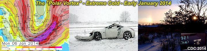
Early January 2014 was a brutally cold period from the upper Midwest to the NE USA - Especially around the first week of January 2014. Once again, similar to 2008, I am working on a computer contract in the windy city of Chicago, and had the excitement of driving right into the worst of the weather on January 5 between Indianapolis and Chicago! A few days after was followed by some of the coldest temperatures in 20+ years, approaching -20 below in Chicago. A blizzard (with winds gusting to 50 MPH and nearly 2 feet of snow) also preceded this vicious cold wave. I barely made the trip from Indy to Chicago as I-65 was shut down for 2 days after I barely made my way through (middle picture below was a common sight).


To the right, ice clouds - resembling cirrus clouds, are near the ground, causing sundogs and other optical effects. To the left, the true presentation of the term "Polar Vortex" (used by many media firms), can be seen at the 250 MB flow. This is no more than a highly amplified trough, extending southward from the polar vortex (wind flow around each pole on the earth).


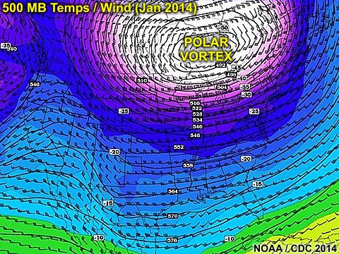
The larger picture above shows the more prominent upper-level low (with temperatures nearing -60 C in its core near Hudson Bay) at the 500 MB level! This allows very cold air to surge unusually far south.

Interested in winter weather? Please visit my section for it at the link below.

http://www.sky-chaser.com/winter.htm