 CHASE TRIP CHRONOLOGY May 17
 - Arrival day. Arrived at Oklahoma City and picked up rental vehicle. Anticipating a few days of "down time" (no storms) I decided to head east on I-44 to spend the night in St Louis, Missouri. The only possibility of weak convection also happens to be in and east of the St Louis area before activity returns to the high plains in a few days.
May 18 - Today was expected to be a total down day which the first half of which was spent in Saint Louis, Missouri killing time. By afternoon, convection began east of the area with enhanced cumulus developing. After checking data and seeing an upper air disturbance moving across eastern and central Illinois and into Indiana, I decided to investigate any convection that might develop. In low dewpoint air, and despite a stiff northwest flow at the surface and aloft, some strong thunderstorms did get going, one of which was intercepted on Interstate 70 near Brazil, Indiana. Time-lape video was also produced for the remainder of the convection. Day was wrapped up for the night in Indianapolis, Indiana. This was the farthest east I ever chased and plans are to head back west for activity in a few days back in the high plains.
May 19 - Down day, with only slight chase prospects dwindling in the extreme southern portions of Illinois and Indiana, I decided to kill more down time with a visit and stay over in Chicago, Illinois since it was about 3 hours northwest of Indianapolis. I also forecasted and found that portions of MO and Kansas may have fair to good chasing prospects for the next day (May 20).
May 20 - Cap bust day. I decided to gamble by side tracking into SW Missouri near Cassville off Interstate 44 (since I had to head back west anyways) after seeing a moderate upper-air impulse sliding SE in the NW flow aloft with a pocket of high CAPE and boundary enhanced helicity (from a stationary front across southern MO) in that region. The only thing was the 700 mb temperatures were too warm, and a capping inversion held solid from the NE side of a 500 mb thermal ridge (to my SW). Waited for any signs of development until about 6:30 PM CDT and nothing happened, despite nearly a 20 degree difference (92 in Cassville with SW winds and 73 near Carthage with SE winds, 40 miles apart). Only elevated showers were observed north of the boundary due to the upper-air disturbance and associated large-scale ascent. Headed north on highway 77 and spent the evening in Harrisonville, MO. The next day (5-21) may be a chase day in western Kansas based on looking at data that evening of May 20.
May 21 - Chase day with two thunderstorms intercepted, one a supercell near Springfield, MO and the other a strong multicell storm near Plad, MO. Today had a nearly identical setup as the one on 5-20 near Springfield, MO so after much forecasting I decided to target that area rather than head west. This time, the cap was overcome since a mid-level MCV was rotating eastward out of central Kansas and two boundaries were in place over the target area. After the interception(s), I headed back to Salina, KS for the night anticipating a drive farther west on 5-22 for possible upslope convection in NE Colorado / NW Kansas.
May 22 - Today was a chase day with good potential which did not come together fully. Began the day by leaving Salina, Kansas after looking at data and forecasting a region of convergence / upslope in NE Colorado / NW Kansas under an approaching shortwave. Headed northwest on Interstate 70 then north to first target area of Wray, Colorado near the tri-state regions of CO, NE, and KS. Storms did develop in that region, but were very high based as dewpoints never reached that region and the upper dynamics had not cleared the Rocky Mountains in time. The storms were strong thunderstorms, one exhibiting weak rotation, but did not get organized. Met up with several other chasers, including Brian Morganti and Jeff Pitrowski and even did a demo of my equipment / interview for a Brazilian film crew riding along with Brian's group. Headed back east to North Platte, NE for dinner and to spend the evening as the next day (5-23) should be another chase day farther east in Nebraska along Interstate 80.
May 23 - Chase day in southeastern South Dakota where high chase prospects wound up with an outflow dominant squall line and many intense gustnadoes. Left North Platte after forecasting and found the best target to be near Chamberlain, South Dakota and nearby areas to the southeast along Interstate 90. Initiation of storms began as expected in the target area by afternoon and continued eastward along Interstate 90 where I met up with other chasers including Tony Laubach near Kimball, SD. The storms became linear and with very strong outflow winds, but a fantastic spree of gustnadoes was caught not far from Letcher, South Dakota ahead of the squall line. The storms encountered also had strong winds and heavy rains. The chase track played the squall line looking for circulations and forward-flank mesocyclones in the gust front. Todays long chase track, once out of Nebraska and into South Dakota, contined east along Interstate 90 into extreme SW Minnesota, then south on Highway 75 into Iowa where Tony Laubach and myself spent the night in Sioux City, Iowa.
May 24 - Today was a long chase day which began early with a forecast that targeted east-central Iowa and west-central Illinois. Tony Laubach and I left Sioux City, Iowa and headed south on Interstate 29 then East on Interstate 680 and 80. We passed Des Moines, Iowa then dropped southeast on Highway 163 into Ottumwa, Iowa where we checked data and met up with a few other chasers. We continued east on Highway 34 into Illinois. With another check of data, we continued to Galesburg, Illinois then north on Interstate 74 to finally intercept developing storms southeast of Moline, Illinois. The storm briefly became a small supercell near Rock Falls, Illinois before splitting and evolving into a multicell line and gusting out. We headed southeast on Highway 52, then to Interstate 39 to wrap up the day with dinner and lodging in Bloomington-Normal, Illinois.
May 25 - Another chase day beginning with Tony Laubach and myself forecasting and targeting east-central Indiana from Indianapolis to the Ohio border as tghe primary target. We left Bloomington-Normal, Illinois and headed east into Indiana towards Indianapolis and stopped at an exit off Interstate 70 where we met another chaser, David Diehl. We continued south towards Eminance, Indiana then towards Bloomington where the first tornado-warned supercell storm was found near Elletsville, Indiana producing small funnel clouds. The storm merged into a squall line so we headed back north and around to the east side of Indianapolis to try to get ahead of the storms, but they became linear and outflow dominant. We continued to the Ohio state line and ended the chase there. I continued back west towards Inidianapolis as Dave and Tony split apart as well. As I continued west, I encountered another severe storm with a spectatular shelf cloud (also outflow dominant) near Interstate 70 near Spiceland, Indiana. The storms continued to become linear, and I wrapped up the day spending the night in Indianapolis,l Indiana.
May 26 - Today was taken to be a travel (down) day to re-position farther west anticipating the next disturbance moving into the high plains. Left Indianapolis, Indiana and headed west on Interstate 70 most of the day and spent the night in Kansas City on the Kansas side. The original plan was to pass "down time" in Chicago, Illinois but plans changed as the rule was to head west. Unfortunately, major storms were missed this day in the western Kansas region as the "new" disturbance was much stronger than forecasts and models depicted. The next day should have activity and Kansas City at least puts any new chase prospects in range.
May 27 - Today was a long shot, a real long shot, which began with a forecast pinpointing the best chance of tornadoes and severe storms in northeastern North Dakota, and I made the trip. I left Kansas City, Kansas at 8:30 AM and headed up highway 29 through Kansas / Missouri, Omaha, Nebraska (where some strong storms were passed by), Sioux City, Iowa then into South Dakota and North Dakota choosing Fargo, North Dakota for the first target. The trip took about 7 hours, and I was in Fargo by 3:30 PM. Upon checking data, the best dynamics and chance of initiation (enhanced cumulus revealed by visible satellite) was about 100 miles to my west, so I headed west on Interstate 94 and found a line of towering cumulus far off to my NW. I headed north on Highway 231 out of Jamestown, North Dakota as the towering cumulus developed into a distant building supercell storm. This storm happened to be NW of Devils Lake, and was intercepted sucessfully with large hail and a rotating wall cloud / funnels. I also decided to go the extra 20 miles to the Canada border before returning to Jamestown, ND for the night as the next day will be a chase day farther south. This day was, put aside hurricane chases, the longest chase ever in my life!
May 28 - Chase day with severe storms intercepted in SW South Dakota. Forecasted in Jamestown, North Dakota to determine today's target area. There were two prospects, one again in northeastern North Dakota (departing surface low) and another in southwestern South Dakota (lee cyclogenesis was a possibility). If the low did not develop SW of South Dakota and the low in NE North Dakota did not move, northeastern South Dakota would have been good for possible storms. I left Jamestown and targeted Aberdeen, South Dakota. Here is where I waited for quite a while, watching the SE winds there quickly go SW as a cold front surged past Pierre to my west. Meanwhile, agitated cumulus appeared on the visible satellite in both NE North Dakota and SW South Dakota, nothing in my area. After another hour or so, the cumulus to the SW kepts building, and was in far better upper-air dynamics, plus slowly backing winds, despite it being in the post-frontal air. There was a very strong cap, and that helf off anything in ND (although an isolated cell fired there). I decided to go with SW SD so I headed southwest to Pierre, then targeted Kadoka, South Dakota. Storms were building rapidly to the southwest, and finally, a violent storm (hail and high winds) was intercepted near Wanblee in the Pine Ridge Indian reservation. After intercepting the storm, it was then a long drive through severe weather along Interstate 90 until west of Kennebec, where it cleared. The night was spent in Chamberlain, South Dakota as the next days chase prospects are SE Nebraska / NE Kansas.
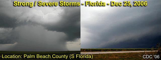
May 29 - Today was supposed to be a chase day farther southeast (NE Kansas / SE Nebraska) but a cold front surged ahead of all the good upper air dynamics, so a long travel day (but trying to play along the front) from Chamberlain, South Dakota down into northeastern Kansas through southeastern Nebraska, then southwest into Liberal in SW Kansas anticipating a good setup for storms on 5-30. Managed to document some dust devils in eastern Nebraska, convection along the stalled cold front in NE Kansas, as well as very interesting dryline induced convection farther in SW Kansas. Also stopped in Hallam, Nebraska along the way to check out how the town was doing after a tornado destroyed it 2 years prior on May 22, 2004. I was delighted to see most of the town rebuilt. Met up with Verne Carlson and Tony Laubach in Liberal to share a room for the night.
May 30 - Chase day in western Oklahoma area. Forecasted and left Liberal, Kansas targeting development southwest of Woordward, Oklahoma. This was a dryline type setup with an outflow boundary and stationary front to play with. An upper air disturbance passed over the target region with an increase in upper winds in the right-rear entrance region of the jet stream flow. The storm was a supercell storm that was followed down and west of Highway 283 from near Cheyenne, Oklahoma to Interstate 40 until it gusted out violently.
May 31 - Departure and travel day. No storms were intercepted today or were in range. Returned the rental vehicle and left Oklahoma City, OK to return to Fort Lauderdale, FL.
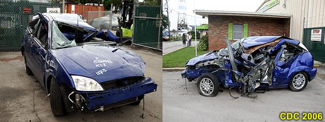
DETAILED LOG FOR ALL CHASES 1). May 18,4:00 PM - Penetration of strong thunderstorms along Interstate 70 just west of Brazil, Indiana. The storms were high-based but produced very heavy rains, small hail, 40-MPH winds, and occasional lightning. The storms developed in a region of strong northwest flow aloft on the backside of a departing upper-level low pressure system. Surface heating and an upper level trough triggered the storms. Documentation was HD video (time lapse) and still images. A 2007 Ford Focus was used to chase the storms.
2). May 21,4:30 PM - Interception of a very severe thunderstorm on the east side of Springfield, Missouri near Interstate 44 and Highway 65. The storm was a classic to LP type supercell storm, which lasted about an hour but dissipated rapidly after moving south of a boundary it developed on. The storm produced heavy rains, 40-MPH winds, and hail to 3/4". Strong rotation was noted with the storm, with some small funnels, an RFD notch, and beautiful "stacked plate" effect on the storm updraft. A low pressure trough, surface boundary interactions / fronts, surface heating, and mesoscale low-pressure area caused the storms. Documentation was HD video and digital stills. A 2007 Ford Focus was used to chase the storm.
3). May 21,4:30 PM - Penetration and observation of a strong thunderstorm near Plad, Missouri along highway 64. The storm was the western most part of a multicell cluster of strong thunderstorms. The storm produced heavy rains, 30-MPH winds, and hail to 1/2". A low pressure trough, surface boundary interactions / fronts, surface heating, and mesoscale low-pressure area caused the storms. Documentation was HD video and digital stills. A 2007 Ford Focus was used to chase the storm.
4). May 22,6:30 PM - Observation of a strong thunderstorm in far northeastern Colorado near the tri-state regions of Colorado, Kansas, and Nebraska along highway 45 / 385. The strong thunderstorm was high based, but developed a weak precipitation core and had very weak rotation before falling apart. The core of the storm was not intercepted. An area of surface convergence, upper trough, upslope orographics, and surface heating produced the storms. Documentation was HD video and digital still photos. A 2007 Ford Focus was used to chase the storm. A severe thunderstorm watch was also in effect for the area until 10 PM CDT.
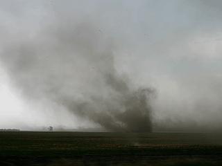
5). May 23,5:00 PM - Penetration of severe thunderstorms and obervation of strong gustnadoes along their gust fronts from near Letcher, South Dakota southeastward as far as western Iowa. The storms were a multicell line of strong and severe thunderstorms and contained wind gusts to 70-MPH with frequent lightning, small hail, and heavy rains. The gustnadoes developed ahead of the line of storms and a few became quite strong (damage observed was tree damage). A low pressure trough (surface and aloft) and surface heating produced the storms. Documentation was HD video and digital stills. A 2007 Ford Focus was used to chase the storms. A tornado watch was also in effect for the area until 9 PM CDT.
6). May 24,7:30 PM - Observation and indirect penetration of a severe thunderstorm near Rock Falls, Illinois along Highway 52 and farther southeast towards Amboy, Illinois. The storm was a small supercell storm that developed at the southern extent of a multicell line of storms. The storm contained lightning, heavy rains, small hail, and wind near 40-MPH where it was penetrated (through a split in the storm). The storm produced quarter-sized hail but the hail core was not deeply penetrated in this storm. A low pressure trough (surface and aloft), cold front, and surface heating produced the storms. Documentation was HD video and digital stills. A 2007 Ford Focus was used to chase the storms. A tornado watch was also in effect for the area until 8 PM CDT.
7). May 25,4:30 PM - Observation a very severe thunderstorm near Elletsville, Indiana near Highway 46. This storm was a small but briefly intense supercell storm with a wall cloud and small funnels produced. Tornado sirens were sounded for the city of Elletsville. The core of the storm was not penetrated, but 40 MPH inflow winds were observed. The storm quickly merged with other storms and formed a multicell squall line. A low pressure trough (surface and aloft), cold front, and surface heating produced the storms. Documentation was HD video and digital stills. A 2007 Ford Focus was used to chase the storms. A tornado watch was also in effect for the area until 10 PM CDT.
8). May 25,7:00 PM - Observation and indirect penetration of a severe thunderstorm north of Spiceland, Indiana north of Interstate 70. The storm was part of a multicell line of strong and severe storms. The storm contained lightning, heavy rains, small hail, and wind near 40-MPH where it was penetrated. A low pressure trough (surface and aloft), cold front, and surface heating produced the storms. Documentation was HD video and digital stills. A 2007 Ford Focus was used to chase the storms. A tornado watch was also in effect for the area until 10 PM CDT.
9). May 27,9:30 AM - Penetration of strong thunderstorms along Interstate 29 south of Omaha, Nebraska just east of the Iowa / Nebraska border in Iowa. The storms were encountered while traveling north, and were elevated multicell cluster type storms. Heavy rains, lightning, and 40-MPH winds were encountered. A upper low pressure trough and left-over convection / outflow boundaries due to an overnight MCS produced the storms. Documentation was digital stills. A 2007 Ford Focus was used to chase the storms.
10). May 27,8:00 PM - Observation and penetration of a very severe thunderstorm in Towner County, North Dakota near Cando along and near Highway 231. The storm was a high-based supercell storm that organized into a tornado-warned (radar indicated) HP supercell storm. The storm had winds over 60-MPH, frequent lightning, heavy rains, and large hail to 1" (quarter sized), although reports of 3" came from nearby (this size was not encountered). A large rotating wall cloud was also observed with this storm, but only some small funnels were produced. A low pressure trough (surface and aloft), stationary front, and surface heating produced the storms. Documentation was HD video and digital stills. A 2007 Ford Focus was used to chase the storms. A tornado watch was also in effect for the area until 12 AM CDT.
11). May 28,9:30 PM - Observation and penetration of an extremely severe thunderstorm near Wanblee, South Dakota in Jackson County in the Pine Springs Indian reservation near highway 44 and Highway 73. The storm was an HP supercell type storm that was on the northern end of a powerful bow-segment in a cluster of severe thunderstorms. This storm had an impressive visual appearance with inflow banding and "stacked plates" appearance on the north "rotating head" cell with a multi-tiered shelf cloud extending southward along the bow segment. The storm did have a wall cloud and rotation, and a tornado warning (radar indicated) was issued for the storm between Wanblee and Long Valley. As the storm approached, 60 to 70-MPH outflow was observed. Conditions in the precipitation core were torrential rains, nearly continuous and frequent lightning, golfball-sizd hail, and winds near 70-MPH. The tornado was not observed since I backed away from penetrating the storm core. Power was knocked out in the town of Wanblee. This storm traveled to the northeast and became a multicell cluster and still produced hail to quarter sized with 65-MPH winds, which was again encountered northeast near Okaton and Murdo along Interstate 90. Power was out also in several towns along Intertstate 90 and a semi-trailer was nearly blown off the road. The storms were caused by an upper trough / jet stream exit region, surface heating of a post-frontal air mass, and developing surface low pressure. Documentation was HD video, audio, and digital stills. A 2007 Ford Focus was used to chase the storms. A severe thunderstorm watch was also in effect for the area until 1 AM CDT.
12). May 30,6:30 PM - Obervation and indirect penetration of an extremely severe thunderstorm from west of Cheyenne, Oklahoma southward along and west of Highway 283 to Interstate 40. This storm had confirmed softball-sized hail, ofcourse that portion of the storm was avoided, abeit close. Upon penetrating the fringes of the storm core, hail to the size ping-pong balls was observed, with torrential rains, frequent lightning with close hits, and 65 to 70-MPH winds. The storm also produced several funnel clouds and had a rotating wall cloud for some time. When the storm gusted out, winds well over 75-MPH were onserved just north of Interstate 40. Tree and sign damage along with flooding ocurred with this storm. The storms were caused by an upper trough / jet stream entrance region, surface heating, dryline, and stationary front / outflow boundaries. Documentation was HD video and and digital stills. A 2007 Ford Focus was used to chase the storms. A severe thunderstorm watch was also in effect for the area until 10 PM CDT.
This concludes the Midwestern United States Chase Log for the first trip in May 2006. The summary includes a total of 8 severe thunderstorms, 4 strong thunderstorms, and 2 tornadoes / funnel clouds. The main chase vehicle conducting all chases was a 2007 Ford Focus rental. This information was prepared exclusively for the National Weather service and the team of Skywarn storm spotters.