Wednesday, November 17, 2010

Hurricane Season Ends (11/30)

The Atlantic hurricane season ended on November 30, 2010. Despite it being the third busiest season in history, NO hurricanes made landfall in the United States. Actually, only weak tropical storms, including Bonnie ever affected the US mainland directly. Anything even worth chasing in the USA was the northern fringes of hurricane Alex (extreme southern Texas in late June), tropical storm Bonnie (near Miami, Florida in late July), and the weak western fringes of hurricane Earl (outer banks of North Carolina in early September).


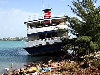
Major international chases were a bit better, and included hurricanes Alex and Karl in Mexico and hurricane Igor near Bermuda. Other than that, MOST major activity stayed in the far eastern Atlantic with storms recurving out to sea long before reaching any land. My hurricane chasing / tropical weather section is updated each year and is in my STORM CHASING section of my web site, and you can click the link provided for it below to jump right to that section.

http://www.sky-chaser.com/stormc.htm

California For 2-Weeks (11/15)

I just got back from a two week trip to California visiting best friends of mine and enjoying the never-ending outdoor and scenic activities to be had there. I covered all scenic aspects of the state, from Los Angeles to San Francisco, from down to the sea and up to the mountains! If you love the great outdoors, California is the place for you ... Heck, I did so much hiking and outdoor stuff I still lost 10-15 LBs despite drinking lots of wine and eating more!


I posted many pictures in my OUTDOORS section of this web site, and you can click the link provided for it below to jump right to that section.

http://www.sky-chaser.com/outdoors.htm

Skydive From 18,000+ Ft (11/13)

One of the extreme activities I did during my 2-week stay in California was a visit to the Skydive Monterey Bay drop zone. They take jumpers to at least 18,000 feet (supplemental oxygen is available) on many skydives and I have a video of two of them I did.


You can see video of this skydive by clicking the link for that area on my web site provided below.

http://www.sky-chaser.com/skygpv3.htm

Storm Chase Vehicles (10/25)

You have seen them on the Discovery Channel and may have seen them on the road while chasing in tornado alley. Myself being a storm chaser, I see them nearly every day when I am chasing during tornado / hurricane season. These are the storm chase vehicles, and they range from privately owned cars, to exotic scientific machines, and even aircraft.


Check out this special new section in my STORM CHASING part of this web site, or click the link for that area on my web site provided below.

http://www.sky-chaser.com/chasev.htm

Wow - Typhoon "Megi" (10/17)

The true violence of a tropical cyclone at maximum intensity is a sight to behold when typhoon "Megi" affected the Phillipines and China a half a world away from the US in the western Pacific basin in mid October 2010. Typhoons are the same systems as hurricanes, just the name if different in that part of the world.


In the image above, typhoon "Megi" reaches maximum intensity as it bears down on the NE coast of the Philippines (Luzon), with insane core winds exceeding 180 MPH with higher gusts. Chasing something like this is like driving into an EF-5 tornado that's 40 miles wide! A handful of chasers intercepted the storm, including James Reynolds (Hong Kong) and Geoff Mackley (Australia). Fortunatly, the landfall area near Davilican Bay was rural and mountainous. This made it hard for any intercepts of the typhoon core there.

Hurricane Paule (10/14)

The "good luck" streak for a non-hurricane landfall in 2010 continues with a very small hurricane Paula weaking to a tropical storm over western Cuba around October 14, 2010. Although "good luck" for most people in the USA, this is very "bad luck" for storm chasers seeking hurricanes to intercept. Paula seemed to be a rather promising prospect as the W Carribbean / Gulf of Mexico is normally active in October. Paula was a very small storm with a core flow barely 50 miles wide, even at maximum intensity when it had 100-MPH winds (the hurricane forced winds barely exceeded 15 miles from the center).


In the images above, note that the storm center (depicted by the red "X" in the satellite images) is on the SW side of the central overcast as strong vertical wind shear / mid-level dry air causes Paula to weaken rapidly over western Cuba.

Skydiving Past Clouds Video (10/2)

Here is another video of a skydive I made using the GoPro "Hero" HD camera. This video shows what it's like to fall through / past a cloud deck (altocumulus undulatus) at speed.


You can see video of this skydive by clicking the link for that area on my web site provided below.

http://www.sky-chaser.com/skygpv2.htm