Wednesday, November 16, 2011

S Florida EF-2 Tornado (10/18)

An EF-2 tornado affected Sunrise, Florida in Broward County on October 18, 2011 during the late evening - I was chasing this storm and encountered the tornado (barely visible by lightning and power-flashes)!


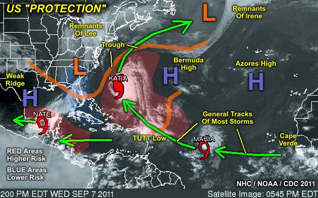
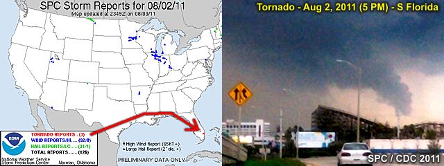
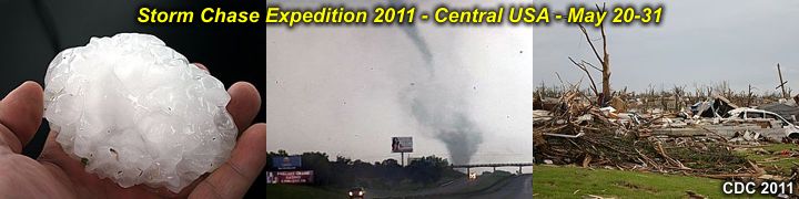
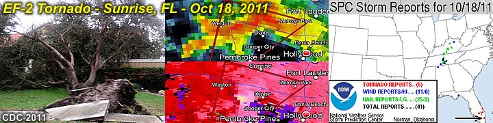
The storm was a classic supercell that originated over the rural areas of western Miami-Dade county (south of Miccosukee in the Florida Everglades) and moved north and northeast over a two to three hour period through the western sections of Broward and eventually southern Palm Beach counties (where it weakened). The storm produced a destructive tornado, with winds at least 120 MPH (EF-2), from Plantation to Sunrise, just north of I-595 and east of NW 136 avenue.

The tornado was about 150 yards wide, and had a damage path, oriented SSW to NNE, over a mile in length. Some information on this chase can be seen in the STORM CHASING section of this web site (in the "PICTURE Log For 2010 And After Chases" section) or you can go right to that area by clicking the link that is provided below.

http://www.sky-chaser.com/stplog4.htm

Sunday, September 11, 2011

Remembering Sept 11 (9/11)

September 11, 2001 was one of the darkest days in American history. It has been exactly ten (10) years since that fateful day. This year (and every year) is a good time to remember those who lost their lives because of a hostile and down-right cowardly act of terrorism inflicted on the United States by the Al Qaeda / Taliban groups.


Who can forget the heroes that fateful day? To skip to more details on September 11, 2001 and many other subjects about the US, click the link that is provided below.

http://www.sky-chaser.com/america.htm

US Tropical "Protection"? (9/7)

The tropics are very busy as of September 7 ... However, little or no threats exist for the US anytime soon! As of September 7-9, hurricane Katia and tropical storm Maria are churning in the open tropical Atlantic, and NOT expected to affect any land. Tropical storm Nate has formed in the Bay of Campeche, and expected to move into Mainland Mexico later this week. As I mentioned, VERY busy Atlantic tropics, but no threat to the USA at this time.


The graphic above shows the general weather pattern during the week of September 7, 2011. Note (in the graphic above) that despite quite a bit of activity in the Atlantic, the combination of a persistent trough off the US East coast as well as weak high-pressure ridging in the southern Gulf of Mexico, the southeastern and eastern US / northern Gulf regions are sort of in a "quiet zone" (blue area) and nestled in between regions of above-normal risk for tropical cyclones (red areas).

Hurricane Irene (8/28)

My interception and hurricane chase for hurricane "Irene" was on August 26-28 in North Carolina after a coastal observation of its effects in South Florida on the 25th.


Hurricane Irene caused over 10 billion dollars in damages and at least 55 deaths, especially in the mid-atlantic region of the United States. A full chase log and write-up is completed and has been posted in the STORM CHASING section of my web site.

You can go right to the link for the chase log by clicking the link that is provided below.

http://www.sky-chaser.com/irene11.htm

South FL Tornado (8/2)

A small tornado in its late stages was caught on camera late in the afternoon of August 2, 2011 from a 5-10 mile distance. In the image below, the distinct funnel stretched along the gust front can be seen just before the tornado dissipated.


Damage was to some homes (roof torn off) with winds near 90 MPH (EF-1). The view is to the north from near Fort Lauderdale Airport as the storm was weakening and just before the tornado lifted.

Wednesday, July 06, 2011

Tropical Storm Arlene (6/30)

With the main part of the the devastating 2011 tornado season behind us, the focus turns to the Atlantic hurricane season that runs from June 1 through November 30.


Tropical storm "Arlene" was the first named storm of the 2011 Atlantic hurricane season, forming in the Bay of Campeche (SW Gulf of Mexico) on June 28-29 and moving into Mexico as a strong tropical storm on June 30.

Be sure to keep up-to-date with both tropical activity and hurricane chasing operations by checking back here often. I have a page showing tropical activity that can be seen by clicking the link that is provided below.

http://www.sky-chaser.com/tropics.htm

Monday, June 06, 2011

Tornado Alley Terror (5/31)

Once again, a major chase trip / expedition has been wrapped up and completed for the central USA from May 20 through May 31, 2011. I have finalized a detailed chase log for this trip.


Unfortunately, this heightened activity came at a very hefty price, especially with a devastating EF-5 tornado in Joplin, Missouri on May 22. These updates can be seen in my STORM CHASING section for MIDWEST 2011 on my web site. You can also go right to that area by clicking the link that is provided below.

http://www.sky-chaser.com/mwcl2011.htm

For a documentary video of the May 20-31 trip storm chasing in the central USA, click the link below!

http://www.sky-chaser.com/m12vid2.htm

Walking On Clouds (5/16)

The image below shows a bunch of skydivers just about to exit a Cessna Caravan 13,500 feet over Clewiston, FL. What's so interesting about the picture? The plane is in a zero-G maneuver (Hint: the guy in the upper-left floating to the ceiling)!


Skydiving is an awesome sport allowing man to become "superman" with only you and gravity being the driving forces once outside of the airplane! See my collection of skydiving pictures and videos in my SKYDIVING section of this web site). Click the link below to see my section on skydiving.

http://www.sky-chaser.com/skydive.htm

You can also click the link below for a cool video of a jump over Clewiston, Florida, buzzing past clouds with my new Saffire 150 canopy and Javelin container!

http://www.sky-chaser.com/skygpv6.htm

Saturday, May 07, 2011

April 2011 Record Tornadoes (4/29)

April 2011 went down as the busiest April in history for the sheer number of tornadoes in the United States for that month. The last week in April 2011 also brought one of the deadliest and devastating tornado / severe weather outbreaks in US history. The below diagram is a composite of all the storm reports during a mere one-week period from April 22nd through the 29th. A total of 2,793 severe storm reports were posted by the Storm Prediction Center (SPC) with a staggering 403 tornadoes (red dots), 1,074 hail reports (green dots if 1" or more and black triangles if over 2"), and 1,316 high wind reports (blue dot if 58 MPH or more, black square if 74 MPH or more)!


Unfortunately, this event took a heavy toll on human life and property, including around 300 people killed. The intercept done on April 24, 2011 by myself (see the STORM CHASING section of this web site for details) in Texas was the START of this horrific outbreak. May God be with the families and people affected by this recent disaster.

For my April 24, 2011 chase (also in my STORM CHASING section of my web site), please click the link below to go right to it...

http://www.sky-chaser.com/mwcl2011.htm

First 2011 Central USA Chase (4/24)

Storm chase season 2011 has BEGUN ... So check back often to see my storm chasing plans for 2011. I have finished a short chase trip to Texas as of late April (with the main chase April 24, one chase day out of an extremely active tornado pattern for April of this year).


This first April (weekend) chase yielded at least three tornadoes near Baird and Abilene, Texas ... Hopefully the start of a fantastic chase year. Storm chase 2011 was AMAZONG ... So check my section for storm chasing in 2011 that can be seen by clicking the link that is provided below.

http://www.sky-chaser.com/mwcl2011.htm

For a documentary video of the April 24, 2011 trip storm chasing in Texas, click the link below!

http://www.sky-chaser.com/m12vid1.htm

Thursday, March 24, 2011

Saint Patrick's Day (3/17)

Happy Saint Patrick's Day to all (March 17) ... Ever wonder what Chicago, Illinois does on Saint Patrick's day? They dye there river a bright GREEN to celebrate!


See these events and much more in my OUTDOORS section of my web site, or jump right to that section by clicking the link for it below...

http://www.sky-chaser.com/outdoors.htm

Japan Earthquake & Tsunami (3/11)

What is today's world coming to - 2012 (for real)? A massive (yes another) earthquake series (the strongest one officially measuring at a staggering 9.0) rattled central Japan (near Honshu) on March 10-11.

Since the earthquake was offshore, it also generated a destructive tsumami that struck the Japanese coast only 10 minutes after the offshore quake. The tsunami also propogated across much of the Pacific ocean with the speed of a jet airliner, affecting many islands (including Hawaii) and eventually the west coasts of North and South America.


The quake and tsunami caused MANY thousands of deaths and even a nuclear disaster as well. Some disturbing video of the Japan Tsumami can be seen by clicking the link below ... Note: video is courtesy of Russia Today media and is an external link to YouTube and might be time-sensitive.

http://www.youtube.com/watch?v=zY2HPT7obWE

It's Still Winter Up North (3/5)

Despite it being quite warm down here in Florida and the south, winter is still in full force in the northern part of the country / Canada.


In the images above, the differences in Horseshoe Falls in Canada can be seen between summer (left) and winter (right). See more winter weather photography and subjects in my WINTER section of my web site. You can also check out the link for it below ...

http://www.sky-chaser.com/winter.htm

Tuesday, February 22, 2011

Site Video Upgrades (2/22)

Most of the videos for this site has been re-done and upgraded via links to YouTube for a MUCH better resolution and claraity. Basically, the video sections on this site work the same, but should be much better in quality. You still should see an embedded video on the screen. If some video links do not work, please let me know.


The video hosting is on YouTube to releive some load off this site, and offer a far greater resolution than the less-compatible (former) RealMedia format. If you want to jump directly to my channel on YouTube, you can follow the link provided below ...

http://www.YouTube.com/cdcollura

ChaserCon 2011 (2/20)

The National Storm Chaser Convention, or "ChaserCon", takes place in mid-late February each year in the Denver, Colorado area. I attended the convention this year for February 18-20, 2011. This exciting event offers a large storm chaser and scientific collaberation with guest speakers, presentations, vendor area, banquet dinner, and video presentation night. Over 300 storm chasers showed up at this event.


You can also jump right to the area for storm chasing events in 2011, including the storm chaser convention, by clicking the link provided for it below ...

http://www.sky-chaser.com/picnic11.htm

For official information on this event, you can also visit their site at the link below ...

http://www.ChaserCon.com

Monday, January 31, 2011

2011 Everglades Boogie (1/30)

The annual 2011 Everglades Skydiving Boogie took place during the weekend of January 28-30 in Clewiston, Florida. This boogie continues to be a fantastic skydiving event, with multiple aircraft (including a helicopter and "specialty" aircraft), the rare opportunity to ride in an L-39 fighter jet, and a great crowd of skydivers to boot!


Year after year, it continues to be an awesome event, put together by the great folks at Air Adventures! You can check out this event, along with many others, in my SKYDIVING section of my web site. You can also jump right to the link by clicking link provided below ...

http://www.sky-chaser.com/skydive.htm

Wednesday, January 26, 2011

FL Tornadic Supercell (1/25)

The first major chase of 2011 was on January 25, 2011 with the interception of a tornadic supercell storm to the south of Sebring, FL in Highlands County. The storm was developing ahead of a squall line of severe storms and quite possibly produced the first tornado to be observed in 2011!


I have pictures posted in my local chase log in the STORM CHASING section of my site, and you can click the link provided for it below to jump right to that section.

http://www.sky-chaser.com/stplog4.htm