Thursday, September 28, 2006

Extreme SE Missouri Storms (9/27)

More severe thunderstorms and incredible lightning was observed on Wednesday, September 27, 2006. This was another solo chase in extreme SE Missouri near Cape Girardeau.


SUMMARY OF THE CHASE

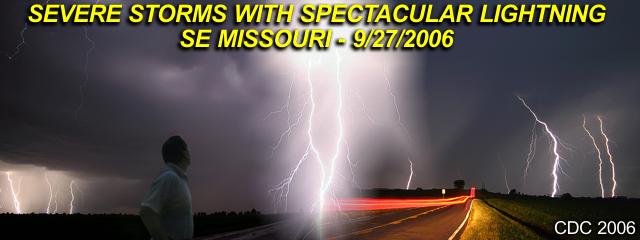
September 27, 2006 was a chase day with severe thunderstorms intercepted in extreme southeastern Missouri and near the southern tip of Illinois, particularly in the areas near Cape Girardeau to Sikeston, Missouri near the Interstate 55 corridor. The chase began in the mid-afternoon leaving Creve Coeur, Missouri west of Saint Louis via Interstate 270, just missing rush-hour traffic. The primary target was pretty much the Cape Girardeau area itself, since while forecasting, a surface boundary (wind shift line) was draped across that area and was well ahead of an approaching cold front, currently over Saint Louis at the time and moving quickly southeast. This boundary also had an increase in moisture, with surface dewpoints nearing the low 60's south of it with SSW winds and upper 50's north of it with more westerly winds.

Also interesting, this surface boundary intersected the cold front to the west of the target area, creating a shallow "triple point". Temperatures in this area also re-bounded into the upper 70's by the afternoon, yielding a surface CAPE of about 1,500 to 2,000 J / Kg. Helicities were also highest in this region, about 100 to 150, not terribly high, yielding an EHI of about 1.0 to 2.0, enough for supercells. Upper winds were moderate to strong, with roughly 40-50 Knots of bulk shear to 6 km (500 MB) and the exit of an H3 jet stream moving in farther up. The only negatives would be the lack of directional shear and the fast storm movements, so a plan for hail and severe winds were the agenda for chasing. At SPC, a slight was issued for the 16:30z outlook, with a 2% tornado probability, 30% hail, and 15% damaging wind. A mesoscale discussion (MD) and subsequent severe thunderstorm watch went up for the same target area.

The trip to the target area continued off I-270 then south on Interstate 55 to the Cape Girardeau area. The surface boundary, with a line of elevated cumulus was encountered about 15 miles to th NW of Cape Girardeau. A severe thunderstorm developed on this boundary and matured near Marble Hill in Bollinger County. This storm was intercepted at about 5:30 PM and followed across Cape Girardeau and across the Mississippi river into Illinois where it weakened near Mclure. Back west, another storm developed near Poplar Bluff, so I headed back west into Cape Girardeau then south on Interstate 55 and got off at Benton, MO where the storm was just southwest of me. This storm became a prolific lightning producer. The storm weakened by about 7:30 PM as it passed near and to the east of Sikeston, MO. Both storms were HP supercell / multicell cluster in nature, and both produced severe winds and hail. No tornadoes were observed, but some small funnels were noted. The chase finished with a drive pretty much back north on I-55 into Saint Louis, then back to Creve Coeur on I-270.

The full chase log and details can be found at the link below...

http://www.sky-chaser.com/mwcl2006.htm

Tuesday, September 26, 2006

Missouri Severe Outbreak (9/22)

Another round of severe weather, including tornadoes, stuck the Midwestern US again on Friday, September 22, 2006. I was out on a solo chase that day in Central and Eastern Missouri initially playing the I-44 corridor and intercepting the tornado at Saint James, MO. The chase continued east into eastern Missouri with more supercells and a developing tornado near Madison County. This was the second major severe weather event in less than one week.


SUMMARY OF THE CHASE

September 22 was a very interesting chase day as I was solo and chasing in my temporary "home" state of Missouri. Left Saint Louis around noon and headed to the southwest along Interstate 44. A developing low pressure area was setting up in eastern portions of Oklahoma / Kansas and backing winds were forecasted to increase in the target area, which was near Rolla, Missouri, along with a warm front, weak dryline bulge to the west, and moisture axis of high dewpoints (lower 70's). Shear was also a big factor in this case, with windfields from 850 MB all the way up to 250 MB extremely powerful, all increasing and veering with height (SSE at surface, SW at 850 MB, W at jet stream level). The core of the jet stream, starting with the exit region at well over 125 knots (at 300 MB) was already in place. Helicities were at least 500 with a forecast CAPE of 2,000.

The trip began heading southwest on I-44 to the primary target area near Rolla, MO. When stopping in Rolla and checking radar, supercells were already developing as I arrived right at the moment of initiation. This storm quickly became a supercell near Vichy, MO and developed a "flying eagle" signature on the radar image. I continued north for intercept on highway 63, and got a great view of the storm, with continuous CG lightning, a nice wall cloud, and striations on its updraft. To stay ahead of this storm, I needed to take some back roads to catch up with Highway 68 to my east, then headed southeast. The storm produced a destructive tornado which passed just 1/4 mile to my south of my position on Highway 68. Debris was noted about a thousand feet in the air, powerlines sparked, and sure enough, the grim damage path was encountered a few minutes later on the north side of Saint James, MO. The tornado was followed along I-44 out of Saint James to Cuba, MO, then farther northeast until it dissapated. The tornado lasted about 14 minutes (starting at 2:35 PM CDT).

Another supercell thunderstorm was encountered in Jefferson County east of Lonedell, Missouri near Highways 30 and 47 at about 4:30 PM. The core of this storm was encountered with golfball hail, and major damage was noted to a ranch while headed south and behind the supercell on Highway 47. This was tornado damage, but the tornado was not observed. A third supercell was encountered in Saint Francios county east of Knob Lick while headed south on Highway 67 at about 5:30 PM. This storm was observed from the backside, but a funnel / possible tornado was noted on its rear flank from about 10 miles away. This storm did produce a large wedge tornado as it crossed into Illinois later (the wedge was not observed). Finally, a fourth supercell storm was encountered near Hillsboro, Missouri along Highway 21 with incredible shelf-cloud structure, strong winds, and large hail around 7:30 PM. I wrapped up the chase and headed back north along Highway 67, then Interstate 270 to western Saint Louis (Creve Coeur) for dinner and returned to my apartment by 9:30 PM.

The full chase log and details can be found at the link below...

http://www.sky-chaser.com/mwcl2006.htm

Monday, September 18, 2006

Chasing Heats Up In Fall 2006

Storm chasing has been strange this year: Slow start to hurricane chasing, below-normal US Great Plains activity in the spring ... But on September 16, 2006 all hell boke loose near Sioux Falls, South Dakota where a single cyclic supercell storm produced at least two major tornadoes.


SUMMARY OF THIS CHASE

Left Saint Louis, MO on Sept 15 and traveled via I-70 west and spent the evening in Kansas City, MO. September 16 was an incredible chase day to say the least, with the simple words "dream chase" a good description. Left Kansas City, MO early after looking at data and decided on a preliminary target of Siuox City, Iowa. A powerful low pressure area was setting up in southern portions of central / western SD and backing winds were forecasted to increase in the target area along with a moisture axis of higher dewpoints (mid 60's).

Shear was the big player in this case, with the left exit region of a 120 knot+ H3 (300 MB) jet stream nosing in to the target area below which had veering winds with helicities around 500 and a forecast CAPE of 3,000 alread being hinted by soundings in the area. The trip began north on I-29 through Omaha where I got breakfast and then caught up with Verne Carlson and his son chasing just north of town. We continued north on I-29 into Sioux City, Iowa where we looked at more data. It soon became clear that the best area was a bit farther north, near Sioux Falls, SD and I preached we head up that way.

A weak boundary was also oriented W to E with a temperature change of about 5 degrees (cooler at 84 F near Sioux Falls, SD) as well as a dryline bulge nudging in from it's southwest. The first cumulus was noted NW of I-29 when about 40 miles south of Sioux Falls, SD and quickly became enhanced / towering. In Sioux City, we headed west on I-90 to intercept the RAPIDLY developing storm, which had a rock-hard anvil and was already severe (then tornado) warned only 45 minutes after initiation. Verne and I made it to the I-90 and Highway 81 overpass where we stopped to observe the rapidly developing wall cloud on the base of the now supercellular storm.

This quickly became tornadic and produced a large tornado which eventually crossed this intersection. We moved east, then northeast as the first tornado, which lasted 15-20 minutes weakened. I continued with the storm north on Highway 19 then east on county road G where a second tornado, lasting about 2 minutes developed and destroyed a house. Verne and I separated at this point, but I met back up with him, and Tony Laubach near Trent, SD on CR G shortly after. We continued east towards Pipestone, MN where a third funnel 1/2 way to the ground was observed (possible 3rd tornado).

The storm continued northeast and weakened at that point. We headed back west towards I-29 to intercept a second supercell storm near Brookings, SD but got there a bit late when the storm was at its severe (bowed segment) stage. We wrapped up the chase and headed back to Sioux City, Iowa for dinner and spent the evening there.

September 17 was a travel day and included the long drive back from Sioux city, Iowa back down I-29 then east through Kansas City, MO on I-70 to Saint Louis, MO, arriving back at my apartment in Creve Cour, MO by 4:30 PM. Total mileage from Friday to Sunday was 1,451 miles

You can view a full chase report on this by clicking the link below...

http://www.sky-chaser.com/mwcl2006.htm

WFFC In July 2006!

I finally attended the World Free Fall Convention (WFFC 2006) in the end of July 2006 in Rantoul, IL!


That's me jumping from an inverted Pitts Special (S-2C) aerobatic biplane about a mile in the air!

This is a week long world-wide yearly skydiving event. Just about every skydive discipline available out of unimaginable types of aircraft are just a few things a skydiver can indulge in here!


The DC-9 jet was there, ready to drop jumpers, for the first time, courtesy of Perris Skydiving in California. This is pretty much a 4-minute ride to over 15,000 feet and an exit out the back at well over 200 MPH - Bam!!

The WFFC footage is also contained in mt web page for skydiving and you can see it by clicking the link below...

http://www.sky-chaser.com/skydive.htm


You can also get a ride in one of these at the WFFC for a generous "donation"! Take a spin in an L-39 fighter jet! I did!

See much more information on the L-39 and other aircraft and flying by clicking the link provided below...

http://www.sky-chaser.com/flying.htm

Saint Louis Derecho In July 2006

I am currently working on a computer programming / IT contract in the Saint Louis, Missouri area from July 3, 2006 through the next 6 months (possibly until November 2006 or as long as through January 2007, depending on the project length). This places me on the edge of Tornado Alley! I still have my original Florida place as well so right now I am literally in TWO residences.


There was a series of extremely severe thunderstorms during the week of July 18, 19, and 21 in the Saint Louis, Missouri area. One such storm was particularly strong on the 19th of July which took a direct hit on the city with winds over 90 MPH and then again on July 21. Power was knocked out to nearly a half a million people with extensive tree and building damage.

You can see a report on this event by clicking the link below...

http://www.sky-chaser.com/mwcl2006.htm