Thursday, December 27, 2007

Off To Chicago (12/31)

Once again, spending 3-4 months or so on a computer project with the University of Chicago starting January 2, 2007 ... Most likely not many storms to chase there - It's the dead of winter and there will, however, be lots of snow, ice, and cold windy weather!


The programming (PICK / MV) project is temporary and should be done in the time-frame shown (or less if something else locally in FL comes up).

Post-Season TS "Olga" (12/12)

Just when we think the 2007 Atlantic Hurricane Season is finished a new tropical storm forms - In DECEMBER - Tropical Storm "Olga"! December storms are rare, but do happen occasionally. This one is interesting as it affected the Caribbean as it headed to the west, an unusual direction for this time of year, due to abnormally strong high-pressure to its north.


The storm headed west and continued weakening as it headed into a region of higher vertical shear / dry air in the western Caribbean - Typical in the tropics in December. The storm eventually weakened into a remnant low and reached the Yucatan Penninsula as no more than a swirl of low clouds before dissipation.

Landspout Tornado (12/8)

Small landspout tornado observed in Palm beach County near South Bay east of Highway 27 in Florida! This was a small tornado (most likely EF-0) that formed along the lake-breeze boundary and under low-topped convective cells.


The landspout lasted about 10 minutes and weakened before reaching Highway 27. In the picture, a clear ground circulation is visible and funnel above it on the parent convective shower - A tornado is a "tornado" - And to much amazement on such a fair-weather day!

Monday, November 19, 2007

Alcatraz Island (CA 11/19)

See the island of Alcatraz and US Penitentiary in the San Francisco Bay! This island was home to a federal prison from 1934 through 1963.


You can check out the link provided below for more information on the wonders of Alcatraz...

www.sky-chaser.com/alcatraz.htm

Wednesday, October 31, 2007

Tropical Storm Noel (FL - 10/31)

Tropical storm Noel passed east of Florida on Halloween 2007 (October 31) but affected the east coast of southern Florida with very high waves and winds well over gale (tropical storm) forced. Check out the footage of this rather weak but interesting tropical system.


You can check out the link provided below for more information on this observation / coastal chase of tropical storm Noel...

www.sky-chaser.com/noel07.htm

Long Island NY (9/25)

Any hint on what the picture below is? Where is it? This is central Long Island, New York, viewed from an altitude of about 23,000 feet on a warm and clear Indian Summer day. The importance of this place is that it's where I grew up, went to school, and lived until I was 16 years old. If you look closely, you can make out a small lake just below the center of the image, that's Lake Ronkonkoma, and my surrounding home-town.


Flying gives one a whole new perspective on our world and where we live. Whether you are an avid pilot, or weary traveler, the view outside the window on that delayed flight just might give you a whole new way one can look at (and appreciate) our world miles below. I have a large collection of flying footage and pictures. You can click the link below to check out my section on flying ...

http://www.sky-chaser.com/flying.htm

Wednesday, September 12, 2007

Remembering 9-11-2001 (9/11)

REMEMBERING SEPTEMBER 11, 2001 ... It has been 6 years since America was attacked by terrorists on that fateful day of September 11, 2001. A good friend of mine described over lunch his horror of seeing the collapse of the World Trade Center from New Jersey 6 years ago on that fateful day.


In rememberance, please visit the link below to remember those lost as we will NOT forget all lost on that terrible day...

http://www.sky-chaser.com/america.htm

Eric Nguyen Passes (9/9)

Eric Nguyen, a close storm chasing associate of mine, passed away on September 9, 2007. Eric was a fantastic storm chaser, forecaster, scientist, and meteorologist and will be missed by many. He is survived by two kids, his wife, and many relatives as he passed at only age 29.


Our love and sorrow goes out to all, especially friends and family, after such a sensless and unfair passing of such a great and enjoyable person. Please visit the link provided below to see more information, including a special scholarship foundation in his name...

www.ericnguyengathering.com

Saturday, September 08, 2007

Skydive Monterey Bay (9/1)

Cool trip to California this past Labor Day weekend of 2007 included a trip to Skydive Monterey Bay near Marina, California. Two jumps from over 18,000 feet were done, the second one a really nice 10-Way RW attempt!


Be sure to check out the pictures in my SKYDIVE section on this site. You can go right to the link by clicking the link provided below ...

http://www.sky-chaser.com/skydive.htm

Hurricane Felix (9/4)

Landfalls of category-five hurricanes are rare, and this is the second one this year. Before hurricanes Dean and Felix, hurricane Andrew was the last category-five hurricane to make landfall in the Atlantic basin back in 1992. The storm came ashore, ironically, near a town called Punta Gorda along the northeastern Nicaraguan coast. As one can imagine, anything in the path of the eyewall of a storm like this would be obliberated, period.


Another Category-Five hurricane! The two pictures above show Hurricane "Felix" with 160-MPH sustained winds slamming ashore in Northeastern Nicaragua during the morning of September 4, 2007. This is just two weeks after another category-five storm (Dean) came ashore farther north.

Lunar Eclipse (8/28)

A lunar eclipse took place on August 28, 2007 and is much different than a solar eclipse. Solar eclipses are caused by the Moon's shadow crossing the Earth, and since the Moon is much smaller than the Earth, the event does not occur planet-wide. A lunar eclipse, on the other hand, can be seen from anywhere on Earth that has a view of the Moon at the time of the eclipse.

An oberver on the Moon during a total lunar eclipse would also see the entire sun blocked out by the Earth from pretty much the entire surface within view of the Earth. The Earth's atmosphere also adds the red tint to the edges of the shadow of a lunar eclipse due to the scattering / filtering of sunlight.


Above is two pictures taken during the pre-dawn morning of August 28, 2007 in South Florida of the full lunar eclipse. To the left, a commercial airliner, leaves a trail of lights as it crosses the camera's view during a time exposure. To the right, the partial light refracted by the earth's shadow paints the face of the moon a red color.

Hurricane Dean (8/21)

Hurricane "Dean" made its category-five landfall with 160 to 165 MPH sustained winds just north of Chetemal, Mexico during the early morning of August 21, 2007. Winds under the northern eyewall included gusts near (or even exceeding) 200-MPH and a minimum central pressure of 906 MB was measured by aircraft prior to landfall. This makes for a rare event having a category-five hurricane, the highest on the Saffir Simpson Scale, to come ashore in the Atlantic Basin. The last category-five hurricane to make any landfall in the Atlantic Basin was hurricane Andrew in 1992. As you can imagine, the devastation under the eyewall of this storm is catastrophic.


In the pictures above, a close visible satellite of hurricane Dean's eye is to the left, showing an incredible "stadium" or "cup" effect. The picture to the right is an enhanced-IR satellite image showing the landfall of Dean in Mexico's Yucatan Penninsula near Chatamal in southern portions of the state of Quantana-Roo during the night / morning of August 21. No chase plans were done on this storm due to the dangers involved, a night landfall, and the threat of being "stuck" for a long time abroad. Some hurricane chasers I know already were held-up in Jamaica after the hurricane brushed them as they chased the storm there during the prior weekend.

Monday, August 13, 2007

Summerfest 2007 (8/3 To 8/5)

A special trip to the SUMMERFEST BOOGIE skydiving event was done during the weekend of August 3-5, 2007. This event was billed as the "WFFC Alternative" ... The WFFC in Rantoul, IL was cancelled this year to the disappointment of many skydivers. The SUMMERFEST event at Skydive Chicago had just about every event the WFFC had that wasn't for 2007.


Aircraft to skydive ranged from a Pitts Special to the Perris DC-9 commerical jet, plus many "standard" jump aircraft. Some pictures can be seen at the link provided below ...

http://www.sky-chaser.com/skydive.htm

Diabetes Can Be Deadly (8/1)

DIABETES KILLS! If not taken care of properly or out of control! Jacinto (Jose) Chong, pictured below, was a long-time friend and roommate of mine whom I knew since early 1994. He passed away after a long battle with kidney failure, paralysis, heart disease, and other diabetic complications. He passed away from heart failure on Wednesday, August 1, 2007 at Plantation West Hospital in Broward County, Florida after undergoing dialysis. His death was rapid, and ended about 5 years of excruciating pain. He was only 44 years old. Diabetes is a killer, fully hereditable, and insidious in many ways as damage is often done to the person before he or she even knows they got it!


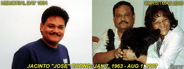
After his death Jacinto was shipped to his home country of Panama for a formal funeral with his family and is survived by his mother, Sonia. He was a mix of Spanish and Asian descent, his father also succumbing to a similar fate at 45 years old. Jacinto was a hard working and good man who started from scratch after leaving Panama in the 1980's during political problems.

He worked his way from nothing in his "new life" in the USA to a career in computer engineering and never hesitated when the time came to give and / or help someone. He supported his large family back in Panama and brought his mother to the states when his health turned. Jacinto was a man who almost never said "no". May he rest in peace, as his suffering is over, and may God bless him to everlasting life and happiness.

A special memorial page, dedicated to this unfortunate victim, has been set up. It also contains important and useful information on diabetes and can be viewed at the link below...

http://www.sky-chaser.com/diabetes.htm

Back In Florida (7/20)

Back in hot and sunny south Florida just in time for Hurricane Season 2007! I have wrapped up my Dayton, Ohio computer project on-time as of the end of July 2007.


Once again, I am home in South Florida and currently working there at another IT job in Fort Lauderdale. The picture above is Florida at its oldest, Saint Augustine.

Monday, July 09, 2007

More Canada (7/6 To 7/9)!

A second trip to Canada was made on July 6 through July 9, 2007. This time, the trip to Toronto was made by flying in instead, to avoid any hassles experienced at the border during the last trip! During this trip, the worlds tallest free-standing structure, the CN tower, was visited with a height of 1,815 feet. Also, see the raging class-six rapids of the Niagara River from aboard a specially designed jet boat. Then, take a helicopter flight over the Niagara great gorge and see the falls from over a half mile up!


You can also view this trip as well as many others by checking out the OUTDOORS section of my web site. You can go right to the area for this trip by clicking the link below ...

http://www.sky-chaser.com/outdoors.htm

Monday, June 18, 2007

Trip To Canada (6/15 - 6/17)

The weekend of June 15 through June 17 was spent in the Toronto area of Ontario, Canada including a trip to Niagara Falls on the Canadian side then a trip to the city of Toronto. Toronto is located on the northwest side of Lake Ontario and is about an hour from Niagara Falls, which is south of the southwest side of the lake. Niagara falls is a spectacular waterfall system between Lake Erie and Lake Ontario where flows from one lake to the other takes place along the Niagara River. This area is also one of the most heavily visited tourist areas in the world. The city of Toronto is also the most ethnically diverse city in the World.


You can also view this trip as well as many others by checking out the OUTDOORS section of my web site. You can go right to the area for this trip by clicking the link below ...

http://www.sky-chaser.com/outdoors.htm

US / Canada Border Problem (6/15)

I had some problems when crossing from the United States into Canada on June 15 Due to "suspicious contents" found on my laptop computer, brought along for both GPS mapping and internet (email). I was detained and subsequently arrested. I spent about 6 hours at the facility, most of that time in a holding cell (aka: "Jail") in Windsor.

It was not until a special investigator scrutinized my laptop and all contents and deemed there was "nothing there" that was illegal. After this terrifying and seemingly un-fair wait, I was released and apologized to and continued on to my destination, with no more than frustration and a 6-hour delay.


The interesting details on how this unfolded can be seen by clicking the link to it provided below ...

http://www.sky-chaser.com/america.htm

Monday, June 11, 2007

High-Risk Chasing (MN / WI - 6/7)

A second and exciting chase day unfolded on June 7, 2007 through Wisconsin and parts of Minnesota and Illinois which was part of my chase trip to the US Great Plains and Midwest was during the period from June 5 through June 10, 2007. On June 7 a high-risk and rough chase landed myself with three tornadic supercell storms and my first experience seeing what GIGANTIC hail can do to a small Midwestern town that was hit by a tornado on one side and the hail on the other!


The chase log for the June 7 storm chase is also online and can be seen by clicking the link to it provided below ...

http://www.sky-chaser.com/mwcl2007.htm

Tornado In South Dakota (6/6)

A long-shot chase trip to the US Great Plains and Midwest was done during the period from June 5 through June 10, 2007. On June 6 a tornadic supercell storm was intercepted near Wanblee, South Dakota. This was the first sucessful chase day of the June 5-10 chase trip.


The chase log for the June 6 storm chase is also online and can be seen by clicking the link to it provided below ...

http://www.sky-chaser.com/mwcl2007.htm

Tropical Storm Barry (FL - June 1-2)

Tropical storm Barry decided to affect Florida with winds and torrential rains just as I was doing a routine visit there from Ohio, where I work (I live and have a house in Florida). The flight into Fort Lauderdale was pretty much rough-and-tumble turbulence through the feeder-bands (left picture) of TS Barry! In the center and right pictures, large waves, wind and rain affect Deefield Beach fishing pier. TS Barry weakened a day later on June 2 near Tampa, FL without much in the way of wind, but gave FL some much needed rains.


There is a small chase log for this storm, adn you can see it by clicking the link to it provided below ...

http://www.sky-chaser.com/ba07.htm

Storm Chase Bust (MN / WI - 5/26)

A chase trip was attempted on a potential setup near the tri-state region of Iowa / Wisconsin / Minnesota and did not really pan out as well as expected due to lack of instability. Such "busts" do happen, and are a part of chasing - Like going out fishing and not catching anything good - Same "hit" or "miss" scenario.


The chase log for this attempted storm chase is also online and can be seen by clicking the link to it provided below ...

http://www.sky-chaser.com/mwcl2007.htm

Friday, May 25, 2007

SVR Storms (TX, OK, & KS - 5/23)

A special trip was made during the mid-week of May 22-24 for a chase day in the Texas / Oklahoma panhandle area on May 23, 2007. During this special "spot-chase", a tornadic supercell was intercepted near Laverne, Oklahoma during the late afternoon of 5-23-2007 and a monster HP supercell storm later on farther southwest near Lipscomb, Texas!


This chase started by Leaving Dayton, OH near 9 PM via a flight to Kansas City, MO arriving at 11:30 PM. Picked up rental vehicle then headed west to Abilene, KS for the night. May 23 was a full chase day in the Texas and Oklahoma Panhandle regions. An all night drive back to Kansas City, MO ended the chase on May 24 with a 5:40 AM flight back to Dayton, OH at 9:40 AM - Yawn!!

The full chase log is now online and can be seen by clicking the link to it provided below ...

http://www.sky-chaser.com/mwcl2007.htm

Monday, May 21, 2007

Kings Island Theme Park (5/20)

Kings Island is another theme park in Ohio (near Cincinnati). This is another place for the roller coaster enthusiast and has many high-thrill attractions. The Beast is the longest wooden roller coaster in the world, with a ride time of nearly five minutes, try it - If you dare!


You can check out some on-ride footage of these amazing coasters as well as other extreme rides at Kings Island by checking out the link provided below ...

http://www.sky-chaser.com/coasters.htm#KINGSI

Dayton Hamfest (5/19)

The Dayton Hamfest (or Hamvention) is a yearly event held at the Hara Arena in Dayton Ohio each year. It receives world wide attention, and hard-core HAM radio operators, along with "casual" HAMs, and even their friends and families, come each year to it. With myself living and working in Dayton, Ohio just blocks away from the Hara Arena, I attended this event on May 19, 2007.


I put many pictures and coverage of this event in the STORM CHASING PICNICS AND EVENTS section of this web site. You can see more by checking out the link provided below ...

http://www.sky-chaser.com/picnic07.htm#CEDARPT

Northern Indiana Chase (5/15)

A round of severe thunderstorms occurred in northern Indiana and parts of Ohio on May 15, 2007. This promped another severe weather chase inwhich two nice gustnadoes (tornado-like vortices created in strong gust-fronts) were observed with an intense squall line west of Fort Wayne, Indiana during the afternoon as well as hail and high winds in Ohio in the late evening towards midnight.


You can also check the status on any storm chases for 2007 in the central USA by clicking the LINK provided below - This should take you to the special section for any storms chased in the central USA during 2007...

http://www.sky-chaser.com/mwcl2007.htm

Monday, May 14, 2007

Storm Chasing Slows In May 2007

The image shown below is the airflow at high altitude over the United States - This is why our chase plans have resorted to "spot chasing" and no long chase "expeditions" ... The "Omega" shaped airflow is due to a BLOCKING RIDGE pattern that has been over the central USA since the first week in May 2007 and can last as long as the entire month of May 2007! These so called "death ridges" can effectively shut-down storm chasing operations in the central US.


Lucky were those who have been out there before the first part of May when the pattern was busy, now it's not, so storm chasing is lame as it was during the "past 2 Mays". We are waiting for this pattern to break so that chasing can resume. On the flip-side, this "quiet pattern" does, however come as a fantastic relief and reprieve to those unfortunate tornado victims of the start of the 2007 storm season, especially those of Greensburg, KS.

Cedar Point Theme Park (5/12)

Cedar Point is a theme park on a penninsula that juts out into Lake Erie in Northern Ohio near Sandusky. Opening day for the season was May 12, 2007 and very busy with long waits and lines, as you can imagine. This place is noted for at least 17 roller coasters plus many other high-thrill attractions.


Many roller coasters here have broken records for their sheer height (called "giga-coasters" or even "strata-coasters"). One of the most notable examples of a "strata-coaster" is the "Top Thrill Dragster" attraction, with a height of 420 feet and a gut-wrenching 10,000 horsepower hydraulic launch system capeable of accelerating an 18 passenger train from 0 to 120 MPH in under 4 seconds!

This Is YOUR Face At 5 Gs - Any Questions?

You can check out some on-ride footage of this high-G monster as well as many others at Cedar Point by checking out the link provided below ...

http://www.sky-chaser.com/coasters.htm#CEDARPT

Tuesday, May 08, 2007

Greensburg, KS Destroyed (5/4)

A very devastating and large tornado struck Greensburg, Kansas during the early evening of May 4, 2007 and destroyed most of the town and killing at least a dozen people. This is the kind of disaster one may not want to witness, no matter how much he or she may like seeing storms.


The picture above was taken by fellow chaser Dan Robinson with STORMHIGHWAY.COM as I was not with him or out chasing in that area. The tornado, called a WEDGE, is about a mile and a half wide and just about to hopelessly take out Greensburg as this picture was taken. The tornado was rated EF-5, the highest on the enhanced Fujita scale, with winds at least 205 MPH extending across a path nearly 2 miles wide.

You can also visit Dan Robinson's great web site, at STORMHIGHWAY.COM by clicking the picture above, or by clicking the link provided below...

http://www.stormhighway.com

Remembering Virginia Tech

Our heart and sorrow goes out to all the victims, friends, and families, plus anyone who has been affected by the senseless and tragic shooting spree that took place at Virginia Tech the day on Monday, April 16 of 2007. This is another horrific example of what kinds of roads people may be headed down in our world today! This is indeed the dark-side of what we all see in the NEWS.


This horiffic event should not have happened, not here in the USA at least. A special tribute section has been set up for it in my area on AMERICA, with more details. Please click the link below to see it...

http://www.sky-chaser.com/america.htm

SVR Storms (S Florida - 5/6)

May 6, 2007 presented a round of severe thunderstorms in south Florida. The storms were caused by a developing low pressure region to the northeast of the area combined with sea-breeze boundaries and a low-pressure trough. Some supercell storms developed by late afternoon, and moved south across south Florida. One supercell storm in Broward County produced a small tornado west of the populated areas.


I was able to intercept some severe weather down in Broward County, south Florida ... For more information with pictures on this supercell storm, check out the link below in my section on storm chasing for 2007 (other storm chases)...

http://www.sky-chaser.com/stlog.htm

For pictures on this storm plus others for 2007 (other chase log pictures), check out the link below...

http://www.sky-chaser.com/stplog3.htm

FTL Air And Sea Show (May 5-6)

The 2007 Mc Donald's Air And Sea Show took place on the weekend of May 5-6, 2007 at the end of Fleet Week. This is a yearly event, since the mid 1990's (originally sponsered by Shell), where over a million people flock to Fort Lauderdale beach to see boats and aircraft of many types and capabilities. This year the Air Force Thunderbirds demonstration team and F22 "Raptor" were some of the biggest stars of the show.


You can check out more about this incredible event by clicking my link on airshow coverage by clicking the LINK provided below - This should take you to the special section for ALL my footage on airshows...

http://www.sky-chaser.com/airshow.htm

Wednesday, May 02, 2007

Northern Ohio Chase (5/1)

Tuesday, May 1, 2007 was an interesting chase in the northern Ohio area where anything from supercells to hail and flash flooding was observed. My STORM CHASING pictures and chase logs have been updated as well for this chase. Click the pictures above to go right to the updated chase log for May 1.


You can also check the status on any storm chases for 2007 in the central USA by clicking the LINK provided below - This should take you to the special section for any storms chased in the central USA during 2007...

http://www.sky-chaser.com/mwcl2007.htm

Soaring Over Illinois (4/28)

Nothing is more incredible than experiencing flight on a sailplane (glider)! Towed into the air to about a mile above the ground, a sailplane has NO ENGINE, and attempts to use THERMALS (rising air) to gain altitude. Piloting a glider is a skill and art, far different than powered aircraft. Using the thermals to gain altitude brings a new respect for "renewable energy" as no fuel is consumed by sailplanes!


Check out the pictures taken at Windy-City Soaring gliding club in Hinkley, Illinois plus much more incredible footage of flying by checking out my secton on FLYING on the Sky-chaser site, or you can click the link below to jump right to it!

http://www.sky-chaser.com/flying.htm

No World Free-Fall 2007 ;-(

A suprise thunderstorm with small hail from 1/4" to 1/2" hit parts of Dayton, Ohio on April 14, 2007 in an environment you would last expect to see such weather. This hail fell on the backside of a strong low pressure system with surface temperatures in the upper 30's and light rain mixing with snow.


The 2007 World Free Fall Convention has been CANCELLED this year! This is to the disappointment of many skydivers from all over the world who look forward to this event each year. For 17 years, this has been a yearly event, originally in Quincy, IL then in Rantoul, IL. I was planning to attend this event once again this year of 2007, and after hearing this news, was more than happy I did so last year in 2006! There is no official news on why this event was cancelled, but you can read about it more by clicking the picture above!

SVR Storms (Indiana - 4/26)

Activity is heating up through out tornado alley and a new approach is in the works for this years storm chasing. There will not be a dedicated "chase expedition" for this year. Instead, only major setups for tornadoes and severe weather will be tackled on a chase-by-day basis. No planning for a trip in May and all the activity in June. No more "sitting" under Rex blocks and ridges for 2-3 weeks. No huge expenses for extended stays and gas. Since just setups will be targeted, a shorter trip JUST for that setup will be the order, with a MUCH greater chance of success, and less time off work to boot!


Some severe weather and even a MINI HP supercell was encountered on April 26, 2007 in eastern Indiana near Union County as a system of thunderstorms passed through the area. A local "backyard" chase was done on these storms and pictures / chase logs have been updated as well.

All such chases in the central USA will be logged in the STORM CHASING section of this site under 2007 CHASES IN THE CENTRAL UNITED STATES, or you can click the link below to jump right to it!

http://www.sky-chaser.com/mwcl2007.htm

Snow And Hail (4/14)

A suprise thunderstorm with small hail from 1/4" to 1/2" hit parts of Dayton, Ohio on April 14, 2007 in an environment you would last expect to see such weather. This hail fell on the backside of a strong low pressure system with surface temperatures in the upper 30's and light rain mixing with snow.

Thursday, April 12, 2007

Indiana "Spot" SVR Chase (4/11)

Some more severe weather was encountered on April 11, 2007 in east-central Indiana as an intense MCS / line of thunderstorms pushed through the area. A local and "impromptu" chase was done on these storms and pictures / chase logs have been updated as well.


Be sure to check often any storm chases for 2007 in the central USA by clicking the LINK provided below - This should take you to the special section for any storms chased in the central USA during 2007...

http://www.sky-chaser.com/mwcl2007.htm

Sea Lions Dancing (California 4/8)

Took a weekend trip to central California for the weekend of April 6 through April 9. The picture below was taken at Santa Cruz pier and wharf on the north side of Monterey Bay on a near-perfect Sunday afternoon.


Two sea lion seals play in the emerald green Pacific waters off Santa Cruz. Click on the link below to see more pictures of animals in their natural habitat as well as pets in my section on ANIMALS...

http://www.sky-chaser.com/animals.htm

First PLAINS USA Chases (4/3)

Some intense thunderstorms were intercepted in central Iowa on Saturday, March 31, 2007 marking the first official chase of the 2007 chase season for me! Another round of storms blasted through Indiana on April 3, 2007 for another early season chase. chase log has been set up for this year, and is for chases in the central / Midwestern USA as I am residing in this area for most of the spring and summer.


Above is a picture of a small funnel associated with a supercell storm near Shelby County, Indiana on April 3, 2007. A special and exclusive chase log has been set up for ANY chases in the Midwest / Central USA for 2007.

Be sure to check often any storm chases for 2007 in the central USA by clicking the LINK provided below - This should take you to the special section for any storms chased in the central USA during 2007...

http://www.sky-chaser.com/mwcl2007.htm

Spring 2007 Arrives (3/20)!

You are probably wondering what the heck the two strange pictures above have in common? Well, they both are significant to the last week of winter and the arrival of Spring 2007! The picture on the left was taken in Chicago, Illinois during the St Patricks day celebrations. A tradition of dying the Chicago River a bright Irish green is a unique sight as boats disperse about 40 pounds of non-toxic fluorescent green dye into the river. The water stays green for about a day or two!


To the right, even stranger still, a hen's egg stands eerily on its end during the spring Equinox at exactly 8:07 PM EDT (0:07 UTC next day) on March 20, 2007. I have tried this many times and the egg stands on its end, as long as its a level and flat / smooth surface. Trust me, there are no tricks here, and if anyone knows what might cause this to happen, please let me know!

FL Severe Storms First Chase (2/13)

East Central Florida saw a round of severe storms producing some strong winds late in the day on Tuesday, February 13, 2007.


A chase log can be seen in the GENERAL FLORIDA CHASING section in the STORM CHASING part of this web site under the logs for 2007 for the SKY-CHASER site.