Friday, December 21, 2012

Sandy Hook Shooting (12/14)

No words can describe the horrific tragedy that happened at the small Sandy Hook elementary school on December 14, 2012. For someone to do this is beyond words - All we can do is pray for these HIGHLY unfortunate victims and hope for some changes in the way people live their lives with such violent intentions.


I cannot comment anymore on this - Sigh (why KIDS?) - Seeing even our US president crying was a bit too much. Sometimes I really wonder where the fine line between God and the "Devil" really exists. More information on such tragic events, as well as the state of the USA, can be seen at the link below.

http://www.sky-chaser.com/america.htm

Hurricane Season Ends (12/3)

The hurricane season for the 2012 Atlantic basin had ENDED as of November 30, 2012. Meanwhile, far away, the Pacific typhoon season rages on with super Typhoon "Bopha" that slammed ashore in the SE Philippines on December 3, packing 160 MPH sustained winds with higher gusts! The Atlantic hurricane season was a pretty busy season, with a total of 19 named storms (up to the "T" storm "Tony"), and the storms "Isaac" and (ofcourse) "Sandy" being the most devastating.


Now we are officially in the "off season" for storm chasing in this part of the world, with winter setting in, and time for the holidays. Plans are underway for 2013, and the trip for "chasercon" (National Storm Chaser Convention in Colorado) has been already booked for February 2013. Details for the national storm chaser convention can be seen at the link below.

http://www.chasercon.com

Friday, November 23, 2012

Hurricane Sandy Effects (10/28)

Hurricane Sandy was observed (indirectly) during its closest approach to the eastern coastal sections of the state of Florida as well. Some of the destructive marine effects were also observed from this storm. Sandy began as a tropical wave that entered the eastern Caribbean early during the week of October 22, 2012. The storm intensified to a tropical storm, then a hurricane, crossing Jamaica and eastern Cuba as a strong Category one hurricane. The storm passed through the eastern Bahamas as a category two storm before merging with an upper air low around October 25. This caused the hurricane to acquire subtropical characteristics, with a very wide wind field that expanded as the storm winds decreased to category one speeds while off the SE US coast.


The storm produced tropical storm forced winds in Florida during its closest approach, and battered the region with very high waves. The waves, surge, and winds continued to expand in coverage from October 28 onward, with the storm passing east of Cape Hattaras and making a left turn back to the NW as it became a 90 MPH extratropical storm just off New Jersey on October 29. The storm made landfall later that same day causing extensive flooding and wave damage to New England and the eastern Seaboard from Florida to Canada! The storm continued inland, as a post-tropical storm, and caused snow and blizzard conditions in West Virginia areas. Observations of this dangerous storm system were mainly coastal and fringe effects of the winds as it passed Florida. The chase / observation logs for Sandy are also available at the link below.

http://sky-chaser.com/sandy12.htm

Typhoon Sanba (9/15)

With the Atlantic and Eastern Pacific tropical seasons struggling to generate a strong hurricane, a different scenario of violence unfolds a half-a-world away in the Western Pacific with Typhoon "Samba". Formerly a category 5 storm, with 170+ MPH sustained winds (gusts over 205 MPH), the storm slammed ashore during the morning of September 15, 2012 on the small island of Okinawa.


Although far away, I know some storm chasers in that area who were there, mainly James Reynolds who lives in Hong Kong. As of the morning (local time), the eastern portion of Okinawa can be seen looking down through the vertical structure of the clear eye, and I can only wonder what anyone there saw (a "stadium effect"? Fog? No wind?) ... The storm came in at 120 MPH sustained winds - Very impressive indeed!

Hurricane Isaac (8/29)

The image below shows Hurricane Isaac near Lake Ponchatrain just east of New Orleans, Louisiana during the morning of August 29, 2012. The storm caused an estimated 3 billion dollars in damages and at least 44 deaths as it travelled from the eastern Caribbean to the central United States. Maximum winds were up to 80 MPH as a hurricane in Louisiana.


The chase logs on Tropical Storm Isaac in the lower FL Keys on August 26 as well as Hurricane Isaac in the northern Gulf coastal states on August 28-29 are available in the TROPICAL section of the STORM CHASING page on my web site. You can also go right to the section on Isaac via the link for it below.

http://sky-chaser.com/isaac12.htm

Thursday, August 16, 2012

Tropical August Begins (8/6)

The tropical Atlantic is started to get busy as we headed into the second week of (early) August 2012. There were tropical storms Ernesto, Florence, and Gordon. Ernesto became a hurricane near Mexico and the other two remained far out at sea.


Hurricane Ernesto moved into the southern portions of the Yucatan Peninsula as a category one hurricane during the late night of Aug 7-8. The night landfall discouraged any chasing of Ernesto (only chaser Josh M from California went there for it). Ernesto weakened in Mexico, but eventually crossed into the eastern Pacific, forming tropical storm Hector. The other two storms, Florence and Gordon, affected only the open north Atlantic and bothered no one as they remained well out to sea (what hurricane chasers call a "fish storm").

Be sure to keep up to date with any tropical activity in the TROPICS section in my STORM CHASING area of my web site. You can also go right to that area (for tropical activity) via the link for it below.

http://www.sky-chaser.com/tropics.htm

Monday, August 06, 2012

Sad USA Moments (7/21)

Simply going to 'dinner and a movie' became far more dangerous in Colorado this week (as of July 20) than skydiving in the eye of a hurricane (statistically that is)! The PERSON who did this is a pure MONSTER, evil as much as (if not MORE than) a terrorist.


This composite image above shows the flags at my skydiving facility at half mast, overlaid to a stock image of INNOCENT folks at a movie - I HOPE this gets some sort of message across. God bless us all, we all will NEED it. For more information on the SAD situation here in the USA, please see my section on AMERICA, which is also available at the link below (make sure you have the 'Kleenex' handy)!

http://www.sky-chaser.com/america.htm

Tropical Storm "Debby" (6/25)

Tropical storm "Debby" formed in the NE Gulf Of Mexico on June 24. This was the FOURTH named tropical cyclone of the 2012 Atlantic hurricane season. In the image below, the "topside" of TS Debby can be seen from a high-flying commercial airliner (en-route from Toronto to Miami) at nearly 43,000 feet!


In the next image below, the storm can be seen as of June 26 as it was about to cross N Florida as a weak tropical storm / depression.


No intercept was done on the storm because of its weak structure. Debby caused severe flooding in Northern Florida, as well as some tornadoes on June 24 in other parts of the state. 2012 has got off to an extremely busy start, with four named storms before the end of June! Keep track of any tropical systems and hurricanes (and plans to chase them) with via the link for it below.

http://www.sky-chaser.com/tropics.htm

Hurricane "Chris" (6/22)

You would think the THIRD named tropical storm (and the FIRST hurricane) of the 2012 Atlantic hurricane season would have my name (tropical storm / hurricane "Chris") on it and be something to chase? Nope, another storm far from any land and a weak system that churned away in the far north Atlantic, but became a hurricane (briefly) on June 21-22. The 2012 tropical season has got off to a busy start, with two named systems BEFORE June 1 (the official start of the Atlantic hurricane season) forming in the Atlantic basin.


Tropical storm Chris, the third named storm of the season, formed in the north Atlantic on June 19, 2012. It bothered no one as it remained well out to sea (what hurricane chasers call a "fish storm"). The storm managed to reach hurricane Intensity on June 21, making it the first minimal hurricane of the 2012 Atlantic season.

Be sure to keep up to date with any tropical activity in the TROPICS section in my STORM CHASING area of my web site. You can also go right to that area (for tropical activity) via the link for it below.

http://www.sky-chaser.com/tropics.htm

Tuesday, June 12, 2012

Chase Expedition 2012 (6/2)

My main storm chasing trip from May 19 to June 2 is completed. The first couple of days was spent observing the annular eclipse (May 20) in New Mexico and some up-slope storms there a day later. During the following week and a half, I intercepted many supercell storms, even seeing the northern lights in North Dakota on May 22 after chasing there! May 25 in Kansas was un-reachable by me and several other chase teams due to chasing too far in Wisconsin on May 24. This was probably WOULD have been the best chase day of my trip.


My tough lesson learned from this is to give up on anything moving east of the Mississippi River and re-position back west. The trip lasted until June 2, with some of the largest hail I ever seen in my life observed wrapping around a tornado on May 29 in Oklahoma. The trip is completed, and a full chase log (including some picture of the annular eclipse) on it can be seen in my STORM CHASING section for MIDWEST 2012 on my web site. You can also go right to that area by clicking the link that is provided below.

http://www.sky-chaser.com/mwcl2012.htm

Tropical Storm Beryl (5/25)

Just a week after tropical storm Alberto formed off the SE US coast, tropical storm Beryl formed in nearly the same location on May 25, making this a very rare early start (two storms forming BEFORE the official start of the season). Normally, the the official start and end dates for the Atlantic hurricane season of June 1 through November 30.


Tropical storm Beryl ultimately came ashore as a 70 MPH tropical storm at night near Jacksonville, Florida on May 26. I was NOT able to chase this system as it happened in the middle of my 2-week long trip chasing severe storms in the central USA. I have prepared the area on my site for tropical updates, and that are can be seen by clicking the link that is provided below.

http://www.sky-chaser.com/tropics.htm

Annular Solar Eclipse (5/20)

The annular solar eclipse (visible from Asia, across the Pacific, and ending in the SW United States) on May 20, 2012 was observed from near Alburquerque, New Mexico.


The footage on the annular solar eclipse in New Mexico can be seen in the STORM CHASING section of my web site for the central United States in 2012. A direct link to this section has also been provided at the link below (one there, scroll down to the date for MAY 20).

http://www.sky-chaser.com/mwcl2012.htm

To see a video of the eclipse, please visit the link that is provided below.

http://www.sky-chaser.com/m13eclv.htm

Tropical Storm Alberto (5/19)

The 2012 Altantic hurricane season has began early this year with the formation of Tropical Storm "Alberto" on May 19, 2012. This is not uncommon as storms sometimes form outside the official start and end dates for the Atlantic hurricane season of June 1 through November 30 (as those are "only" dates).


Tropical storm Alberto, the first Atlantic storm of 2012, was a minimal and compact tropical storm that churned off the coast of the SE United States. With the early start to the 2012 hurricane season in the Atlantic, I have prepared the area on my site for tropical updates, and that are can be seen by clicking the link that is provided below.

http://www.sky-chaser.com/tropics.htm

Sunday, April 22, 2012

New Buddha Religeon Section (4/21)

I did a project to setup a separate area on my web site dedicated to the Buddha religeon. This is separate from the main pages on my site, and has been placed there as a special religeous project for some voluntary work I have been doing for a local Buddha temple.


This new and special area on this web site can be seen by clicking the link for it below.

http://www.sky-chaser.com/audiobook/index.htm

Tornado Outbreak Chase (4/14)

I have completed a storm chasing trip in the Central USA (Kasnas) from April 13-15, 2012 with numerous tornadoes intercepted on Saturday, April 14, 2012 in Kansas. This setup was a high-risk setup, with deadly tornadoes affecting this area, and a tornado outbreak occurred. In this chase trip, the entire lifecycle of a violent tornado was observed and documented on Saturday, April 14 near Geneseo in Rice County, Kansas - Rated EF-4 and being on the ground for almost an hour.


I have finally completed a full-chase log for this event, and it can be viewed in my on-going section for storm chasing in 2012 that can be seen by clicking the link that is provided below.

http://www.sky-chaser.com/mwcl2012.htm


For a documentary video of the April 14, 2011 extreme storm chasing in Kansas, click the link below!

http://www.sky-chaser.com/m13vid1.htm

Thursday, April 19, 2012

Weekend Chase Planned (4/13)

Storm chasing is heating up and a MAJOR severe weather setup appears to be on tap for the weekend (especially Saturday, April 14) in the central USA. I was able to get tickets and will be flying out on Friday the 13th of April, chase Saturday (the 14th in Kansas), and return on Sunday the 15th!


In the image above, a moderate risk (later upgraded to high) was in place as per the Storm Prediction Center (SPC) on Thursday, April 12.


In the above image, issued by SPC on Friday, April 13 (for Saturday the 14th), a rather scary hish-risk (with 60% hatched probabilities) outlook and chilling text was published as a "high-end life threatening event"! A full-chase log for this event will be available (in my on-going section for storm chasing in 2012) once this first major chase is completed, and that area can be seen by clicking the link that is provided below.

http://www.sky-chaser.com/mwcl2012.htm

Sunday, March 18, 2012

Spring Break Trumps Chasing (3/18)

During a rather active start to the storm chasing season of 2012 ... A rather frustrating and down right agonizing scenario unfolds to a storm chaser stuck in the "corners" of the country. No, it's NOT because of work, school, family, or what not - But for folks living in the middle of the USA - Read no further (this does NOT apply to you).


In the images above, to the right we see a nice setup example (March 18) unfolding across some favorable and fun storm chasing terrain, and on a WEEKEND to boot. The problem NOT visible here is the TIME of the year - SPRING BREAK. Take a look to the left image ... Yes, nearly $1,500 to fly from Fort Lauderdale to Kansas City - Yes, that's REAL. Most other airlines simply don't even HAVE any seats left.

Any my free tickets on SW - Out of the question, they were smart enough to back those out this weekend. This is WHY I normally do not chase storms before mid April. Aside the linear and fast-moving nature of storms and setups, chasing before late April is just impossible if you are not within driving distance of the central USA.

Monday, March 05, 2012

Bad Start For March (3/2)

The beginning of March 2012 was marked by a very tragic and unfortunate tornado outbreak on Friday, March 2. An outbreak of tornadoes, some violent, occurred during the afternoon on March 2 across Alabama, Indiana, and Kentucky. As of March 5, the death toll stands at 39 people, including a 15 month old baby who died a few days later in the hospital after being carried 10 miles by a tornado after both her parents were killed. This is a very sad and unfortunate severe weather event.


In the image above, taken from a Boeing 737 aircraft flying at an altitude of about 39,000 feet, the distant but ominous supercell storm can be seen prominently looming over the 40,000 foot cirrus deck and extending high into the stratosphere. The flight path was over TN / VA at the time, with the view in the picture westward towards I-64. Right about the same time of this subtle image was taken, tornadoes "under" that same cloud were already killing people.

Friday, March 02, 2012

"Cut To The Chase" DVD (3/1)

This is a career-long compilation of some of the most intense moments of storm chasing with footage as far back as 1987 (almost 25 YEARS of storm chasing). The most boring parts have been edited out and this DVD has almost two hours of non-stop high-action video! See every form of extreme weather, from thunderstorms and flooding to hurricanes, tornadoes, and even blizzards! See some of the gripping footage from hurricane chasing projects, including the violent hurricane seasons of 2004 and 2005.


See tornadoes intercepted in just about every corner of the Central US, as well as their devastating aftermath. This DVD just about has it all - And then some! For more information and how to order this DVD, click the image above or the link provided for it BELOW.

http://www.sky-chaser.com/offers13.htm

This is NOT all that is available in my DVD collections for sale ... Be sure to check out the latest DVD production above, as well as many others by visiting my special "offers" page for video documentaries at the link provided BELOW as well.

http://www.sky-chaser.com/offers.htm

ChaserCon 2012 (2/19)

I attended the National Storm Chaser Convention (also known as "ChaserCon") in Denver, Colorado from February 17-19, 2012 ... This continued to be another fantastic yearly event that brought in storm chasers from all over the US (and beyond) to collaborate in a three-day event in the mile-high city. Having everyone together and the way Roger Hill and Tim Samaras ran the operation was an experience second to none.


What an awesome job, from Andy Gabrielson's touching tribute to video night and spotter training, and over 350 attendees to make it all the better. Imagine having dinner with keynote speaker Sean Casey (IMAX film-maker and inventor of the TIV), seeing Tim Marshall's fantastic presentations, and Howie Bluestein just to name a few ... That's what ChaserCon does - Brings us all together to enjoy our passions!

You can also jump right to the area for storm chasing events in 2012, including the storm chaser convention, by clicking the link provided for it below ...

http://www.sky-chaser.com/picnic12.htm

For official information on this event, you can also visit their site at the link below (link may be time sensitive / subject to change without notice) ...

http://www.ChaserCon.com

2012 Everglades Boogie (1/28)

Each year, Skydive Air Adventures outside of Clewiston, Florida (at Airglades airport) hosts the "Boogie over the Everglades" skydiving event on the last weekend of January. This yearly "boogie" (what skydivers call a "special event") draws a crowd of hundreds from many areas of the United States (and some other countries as well) and has everything from specialty jumps (such as high-altitude or jumps from a helicopter) to skydives from multiple aircraft (Skyvan, DH6 Otter, and A-90 King Air) plus a big party with free beer each night of the 3+ day event.


Air Adventures skydiving continues to make this a well-anticipated and well done event year after year. Weather, although predicted to be bad, turned out to be fantastic as well - For pictures / video of this exciting event, please visit my SKYDIVING section of my web site. You can also jump right to the link by clicking link provided below ...

http://www.sky-chaser.com/skydive.htm

Happy New Year 2012 (1/1)

Wishing everyone a happy and safe New Year for 2012 ... Hopefully this year will be another great year for storm chasing and outdoor activities - But hopefully without the horiffic loss of life and property damage we saw in 2011.

Hurricane Season Ends (11/30)

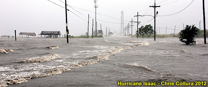
The Atlantic hurricane season runs from June 1 to November 30. Oficially, the 2011 hurricane season is over. To re-cap, the 2011 season was pretty busy, but the only real disastrous storm (affecting land) was Hurricane Irene in late August 2011 (chase log is BELOW for Irene).

http://www.sky-chaser.com/irene11.htm


The rest of the season was burdened by tropical cyclones that were either highly-sheared and / or remained out to sea. All in all, a total of eighteen (18) named storms developed, six (6) of which became hurricanes (three (3) of the hurricanes were major hurricanes). Only one hurricane was intercepted in 2011, that being hurricane Irene. Some other chasers chased hurricane Jova on Mexico's west coast (near Manzanillo) this year as well.

Hurricane Rina (in late October 2011) was another awesome candidate for a chase in Mexico, I actually had tickets booked and all, but the shear ripped Rina apart, and the chase was called off within mere hours of going. The storm was forecasted to hit Mexico during the mid-day hours near Playa Del Carmen / Cozumel as a 120 MPH+ storm, but the shear did not relax, and she came in at night as a 45 MPH dissipating cyclone.


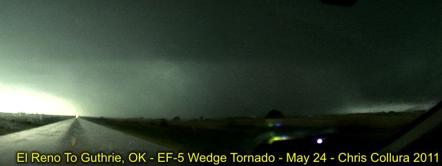
Meanwhile, 2011 lived up to its name as the "year of the tornado" on Nov 7, 2011 in Oklahoma with a late season supercell producing at least six tornadoes some of my fellow chase partners intercepted - Again, the "shear" that never relaxed! For tornadoes in 2011, see the link BELOW as well!

http://www.sky-chaser.com/mwcl2011.htm