Thursday, November 12, 2009

A Slow Chase Year For Me (11/12)

For storm chasing, at least for me, 2009 was one of the slowest and one of the worst chase years ever encountered. Shear in the tropics, ridging in the plains, work, Murphy's Law? - Oh My!


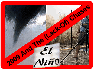
What happened? A brief explanation on the why's and how's of such a bad chase year for many are outlined below.

1). El Niño ... This is a warming of the eastern tropical Pacific off South America near the equator. It's a 2 to 5 year cycle (ENSO) and causes a "trough-east and ridge-west" pattern over North America with the "dreaded" Hudson-Bay Vortex pattern in the late Spring. The ridging over the western US is very BAD for storm chasing prospects there, especially during prime chase season, from Mid May to Mid June. The same pattern also caused most low pressure systems entering the central USA to be generally weaker than normal. Forecast models also performed very bad this year, making a planned chase trip very difficult. A three-week-long "death ridge" also plagued the central US in May 2009, forcing me to cancel my 10 day chase trip there.

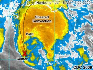
2). Unusually inactive Atlantic Basin hurricane season. Also due to the effects of El Niño, which ruined chase prospects for severe weather in the central USA, also ruined any hurricane chasing opportunities. The El Niño causes strong winds aloft, not over the central US, but over the tropics, due to the "tough-east" pattern. The upper-level shearing associated with such a pattern supresses development of tropical cyclones, along with dry air in the mid levels. Any tropical cyclones that did develop were short-lived, generally weak, or over unusual areas of the Atlantic Basin. In response, the Pacific basin, especially the western Pacific, was ABOVE normal in 2009.

3). Bad timing - This was the most serious problem in 2009. Anyone may disagree with me, especially seeing other chasers success, especially in Mid-Late June of 2009 (if you see Reed Timmer on "Storm Chasers", you'll know what I mean). Not everyone had a bad year in 2009. Fellow chaser Jim Edds even went to Guam for a while to take advantage of the ABOVE normal Pacific typhoon season in 2009. My situation was very bad timing, and work conflicing with available chase time. For example, the ONLY good week in the central US in 2009 was around June 17 ... But that week, with my boss on a funeral and me filling in for another on a cruise, that was the ONLY week I could NOT take off and chase.

With planning for next year (2010), hopefully this El Niño pattern will fade to a neutral ENSO or even a mild La Niña (it's opposite). The La Niña pattern is much better for central USA chasing in the spring, and a better tropical season in the Atlantic basin to follow. Good chase years, such as 1995, 2004, 2005, and 2008 were all La Niña years, with a "tough-west and ridge-east" pattern lacking the Hudson-Bay Vortex. In spring and summer 2010, I will also have a lot more time to take off, given I am still working at the time.

Hurricane "Ida" And Her Demise (11/9)

You have probably seen hurricane Ida during the early week of November 9, 2009. The question is that "Did I chase Ida"?


The short answer is "no". This was because although Ida was a hurricane for a while, it rapidly weakened during the day of November 9, 2009 and made landfall at night. The storm also tracked along an unseasonably straight path towards the northern Gulf of Mexico.

This is the worst track for an intercept, because this took the storm over cold waters and close to a jet stream (shear) on that path. With such a weak storm, barely tropical at landfall, coming in over Alabama, and during the NIGHT / early-morning Tuesday (11-10), any possible chase was abandoned / not worth the time and effort.

Normally, these storms take a path to the north, then northeast (into SW Florida) this time of the year, but not this one, in 2009 (ofcourse).

Autumn In Niagara Falls (10/24)

The end of 2009 is approaching fast as we enter the mid fall of 2009 (October to November). Not much to notice in terms of the change of seasons down here in South Florida (not even anything in the tropics intercepted during the entire season), but take a trip up to the Northern USA / Canada and you can catch the peak of the fall foliage colors as of late October 2009!


Be sure to check out my section on WINTER weather on my main web site for more amazing pictures of winter weather and such. You can also click on the link provided below to jump to that section ...

http://www.sky-chaser.com/winter.htm

Storm Chasing In Central USA (10/3)

A last-ditch effort chase trip to the central US was done during the week from Wednesday (9-30-2009) and Thursday (10-1-2009). I took advantage of both time available to take off as well as airline points and headed out to the Central US for a potential severe weather setup from late Tuesday (9-29) and retured the morning of Friday (10-2).

This is for the "second season", where severe weather sometimes occurs in the fall months. Besides hurricanes (which none were intercepted), this looked like a good chase opportunity of 2009.


Unfortuately, and quite typical of 2009, the forecast models over-estimated the setup, and the atmosphere over Kansas remained capped on 9-30 and only a squall line was the main event a day later on 10-1.

The chase log can be seen in the STORM CHASING section of this site, under "Central US chases of 2009", or you can click the link provided below to go right to it ...

http://www.sky-chaser.com/mwcl2009.htm

French TV Crew Storm Documentary (9/18)

On Thursday and Friday, September 17-18, myself and a French TV crew from Washington DC (for TFI) did some filming of my storm chase vehicle as well as interviews and equipment demonstrations.


The series aired in October 2009 and a clip of the production can be viewed at the link provided to it below ...

http://videos.tf1.fr/jt-20h/quand-le-climat-se-dechaine-4836630.html

Note: Link above may be "time sensitive" as it is not hosted on my site. The production is in French, but you can see myself and others in a VERY well-done segment!