Hurricane "Dean" made its category-five landfall with 160 to 165 MPH sustained winds just north of Chetemal, Mexico during the early morning of August 21, 2007. Winds under the northern eyewall included gusts near (or even exceeding) 200-MPH and a minimum central pressure of 906 MB was measured by aircraft prior to landfall. This makes for a rare event having a category-five hurricane, the highest on the Saffir Simpson Scale, to come ashore in the Atlantic Basin. The last category-five hurricane to make any landfall in the Atlantic Basin was hurricane Andrew in 1992. As you can imagine, the devastation under the eyewall of this storm is catastrophic.
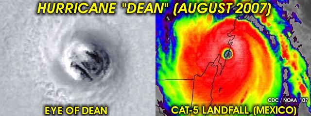
In the pictures above, a close visible satellite of hurricane Dean's eye is to the left, showing an incredible "stadium" or "cup" effect. The picture to the right is an enhanced-IR satellite image showing the landfall of Dean in Mexico's Yucatan Penninsula near Chatamal in southern portions of the state of Quantana-Roo during the night / morning of August 21. No chase plans were done on this storm due to the dangers involved, a night landfall, and the threat of being "stuck" for a long time abroad. Some hurricane chasers I know already were held-up in Jamaica after the hurricane brushed them as they chased the storm there during the prior weekend.
No comments:
Post a Comment