The "good luck" streak for a non-hurricane landfall in 2010 continues with a very small hurricane Paula weaking to a tropical storm over western Cuba around October 14, 2010. Although "good luck" for most people in the USA, this is very "bad luck" for storm chasers seeking hurricanes to intercept. Paula seemed to be a rather promising prospect as the W Carribbean / Gulf of Mexico is normally active in October. Paula was a very small storm with a core flow barely 50 miles wide, even at maximum intensity when it had 100-MPH winds (the hurricane forced winds barely exceeded 15 miles from the center).
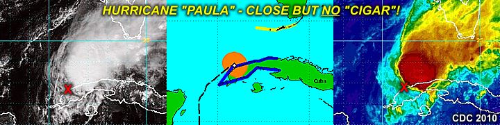
In the images above, note that the storm center (depicted by the red "X" in the satellite images) is on the SW side of the central overcast as strong vertical wind shear / mid-level dry air causes Paula to weaken rapidly over western Cuba.
No comments:
Post a Comment