Wednesday, November 17, 2010

Hurricane Paule (10/14)

The "good luck" streak for a non-hurricane landfall in 2010 continues with a very small hurricane Paula weaking to a tropical storm over western Cuba around October 14, 2010. Although "good luck" for most people in the USA, this is very "bad luck" for storm chasers seeking hurricanes to intercept. Paula seemed to be a rather promising prospect as the W Carribbean / Gulf of Mexico is normally active in October. Paula was a very small storm with a core flow barely 50 miles wide, even at maximum intensity when it had 100-MPH winds (the hurricane forced winds barely exceeded 15 miles from the center).


In the images above, note that the storm center (depicted by the red "X" in the satellite images) is on the SW side of the central overcast as strong vertical wind shear / mid-level dry air causes Paula to weaken rapidly over western Cuba.

Skydiving Past Clouds Video (10/2)

Here is another video of a skydive I made using the GoPro "Hero" HD camera. This video shows what it's like to fall through / past a cloud deck (altocumulus undulatus) at speed.


You can see video of this skydive by clicking the link for that area on my web site provided below.

http://www.sky-chaser.com/skygpv2.htm

Monday, September 27, 2010

Skydiving HD Video (9/26)

With last week's chase of hurricane "Igor" in Bermuda, my new GoPro "Hero" HD camera was indispensible for getting some of the amazing shots. With such a rugged waterproof and stable enclosure, it can be mounted just about anywhere. This time I did one of my "regular" skydives with this tiny tapeless camera affixed to my left wrist. The HD video it captured was awesome, and all extreme sports (skydiving included) are taking advantage of this.


The images above were captured during one of my skydives with the camera on my wrist, offering a unique perspective. You can see video of this skydive by clicking the link for that area on my web site provided below.

http://www.sky-chaser.com/skygpv1.htm

Hurricane Igor Chase (9/21)

I am finished with a pretty successful hurricane Igor interception in the tiny island of Bermuda. The hurricane chase was from Saturday, September 19 through Tuesday, September 21, 2010. I am back in Florida in the United States and I have prepared a chase-log for the storm.


You can see my intercept of hurricane Igor (my chase log for it) by clicking the link for that area on my web site provided below.

http://www.sky-chaser.com/igor10.htm

Hurricanes 2010 (9/15)

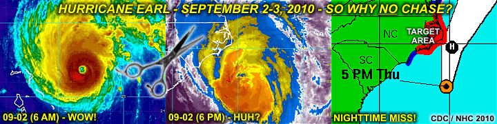
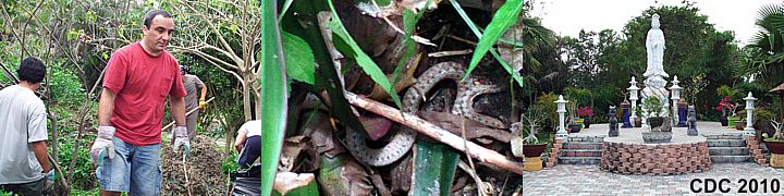
The Atlantic hurricane season of 2010 has been a very active season so far (as of mid September 2010); however, none of the most violent storms have affected land. The above-normal sea surface temperature anomaly in the far eastern Atlantic is producing more hurricanes, but fortunately the development so-far-out east is actually causing the Eastern US to be spared, with hurricane Earl being the closest shave of one of these missing-the-US storms.


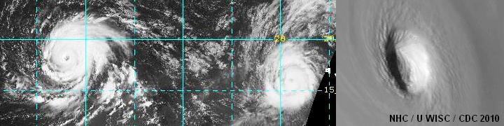
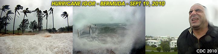
In the image above, two powerful hurricanes (Igor and Julia) are raging in the far tropical Atlantic, far from any land. The image to the right is a close-up of the eye of Hurricane Igor at maximum intensity on September 13. None of these storms were affecting anyone at this time; with fish, birds, and whales most likely the only "beings" experiencing the fury of these hurricanes! Even ships do not travel through that part of the ocean very often.

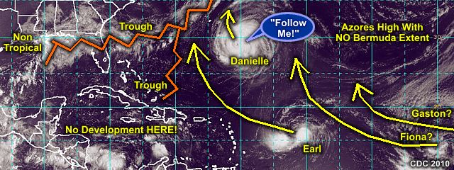
During the Cape Verde season (September), tropical waves normally move off Africa and do not develop into a close circulation until making their way across the ocean (near the Windward Islands). An "open" tropical wave, like a wave in a river going across the current, can propagate THROUGH a trough / weakness in the steering flow (still move WEST although the trade wind flow is SE). Tropical cyclones that develop RIGHT OFF the African coast, often gain latitude (they do NOT move due WEST, but more WNW). This is because a CLOSED low always moves with the flow it’s embedded in (if the trade winds are SE nearing a trough, the low moves NW, not WEST like an "open" tropical wave would).

By the time these systems reach the western Atlantic (near longitude 60 to 65 west or so), they have already missed the northern Antilles / Puerto Rico, and are more susceptible to be picked up by a stronger trough and re-curve into the westerlies and into the North Atlantic. Sometimes the tiny island of Bermuda is affected by these, but a DIRECT hit there is rare.

You can also check my area on tropical weather and any associated activity / chase plans by clicking the link for that area on my web site provided below.

http://www.sky-chaser.com/tropics.htm

Thursday, September 02, 2010

Why No EARL Chase? (9/2)

Hurricane Earl is passing to the east of the outer banks of North Carolina giving folks (and many chasers) there the WEAKER side of the storm (left side), a night-time event, and a weakening system due to shear (strong winds aloft). I was a go for this storm just a day ago, packed up and ready to head to North Carolina from south Florida.


The chase was cancelled at the last minute with both careful consideration and great deliberation. As good as the storm looked early on Thursday, September 2, increasing wind shear caused steady weakening of the system, as well as a jog OFF the coast (no landfall). Storm chasers there, even on Cape Hattaras, should only experience hurricane forced gusts (at best) and big waves, and in total darkness.

You can also check my area on tropical weather and any associated activity / chase plans by clicking the link for that area on my web site provided below.

http://www.sky-chaser.com/tropics.htm

Monday, August 30, 2010

Remembering Katrina (8/28)

August 28 marks the 5th anniversary of Hurricane Katrina in the Northern Gulf Coast in 2005. This storm was a devastating storm, with a record storm surge approaching thirty feet in height, that caused massive devastation and loss of life from New Orleans and eastward to Mobile, Alabama.


You can read more about Hurricane "Katrina" in 2005 and see a full chase log / story in the STORM CHASING section of this site. The link to this incredible chase log has also been provided at the link below.

http://www.sky-chaser.com/kat05.htm

US Protection? (8/26)

Tropical activity in the far Atlantic basin is picking up quite a bit as of late-August / early-September 2010, however, a persistant trough off the US East coast may deflect any intense activity out to sea for the time-being. Bermuda may offer some very remote chase prospects, but happens to be a very small (and unlucky) target if hit directly.


Right now, the US East coast will remain "vaccinated" from anything coming across the Atlantic. Intense hurricane Danielle and MOST storms behind it may actually follow the same path by recurving out to sea (hurricane chasers call these "fish storms". This pattern is good news for most people, but HORRIBLE news for hurricane chasers, who intercept / study tropical cyclones. But, it "is what it is".

You can also check my area on tropical weather and any associated activity / chase plans by clicking the link for that area on my web site provided below.

http://www.sky-chaser.com/tropics.htm

Remembering Charley (8/13)

Friday the 13th in 2010 marks the 6th anniversary of Hurricane Charley in Punta Gorda, Florida (2004). Hurricane names are re-used every 6 years for the Atlantic basin, unless a storm causes devastation and / or deaths. Hurricane "Charley" was a strong and devastating category 4 storm with 145-150 MPH sustained winds at landfall.


The name "Charley" has been retired and THIS (2010) year's replacement was "Colin", which occurred in early August as a weak and minimal tropical storm and was barely noticed by most. You can read more about Hurricane "Charley" in 2004 and see a full chase log / story in the STORM CHASING section of this site, or click the link to go right to it below.

http://www.sky-chaser.com/char04.htm

Saturday, July 31, 2010

Tropical Storm Bonnie (7/23)

The tropics will continue to get more active as we move into late July and early August. As of July 23, tropical storm Bonnie has formed and hit south Florida as a weak tropical storm. The storm crossed Florida and weakened in the northern Gulf of Mexico a day later.


This system was also my first tropical cyclone intercept of 2010. A chase log for tropical storm Bonnie in July 2010 can be seen by clicking the link provided for it below.

http://www.sky-chaser.com/bonn10.htm

You can also check my area on tropical weather and any associated activity / chase plans by clicking the link for that area on my web site provided below.

http://www.sky-chaser.com/tropics.htm

Canada Trip (6/20)

With storm chasing done as of the start of June 2010 and hurricane season for the Atlantic basin just around the corner, a trip to Canada was a great get away from Florida. I finished a great trip with a best friend of mine and visited the Niagara Falls / Toronto area for a few days.


You can check out details on my trips to Canada as well as MANY other places by clicking on the link provided below.

http://www.sky-chaser.com/outdoors.htm

Monday, June 14, 2010

Main Central US Chase (6/5)

The third and MAIN storm chase trip to the central USA in 2010 (May 18 through June 1) is completed and a full chase log is finished and available. This trip also boasted some high-risk chasing as well as at least 20 (yes, TWENTY) tornadoes and numerous supercells, some with large hail and / or incredible storm structure.


You can also visit my chase logs for this main chase, as well as others in 2010, in my STORM CHASING area on my web site. The link to jump right to the are for this main chase trip for May 18 through June 1, 2010 is also provided below.

http://www.sky-chaser.com/mwcl2010.htm

Monday, May 17, 2010

Oklahoma Tornado Outbreak (5/15)

The second storm chase trip to the central USA in 2010 (May 8-13) is completed and a full chase log is finished and available. This trip boasted some high-risk chasing as well as several tornadoes and / or supercells, some with some incredible storm structure.


You can also visit my chase logs for 2010, which includes this event and others, in my STORM CHASING area on my web site. The link to jump right to the storm chasing area for 2010 is also provided below.

http://www.sky-chaser.com/mwcl2010.htm

Monday, April 26, 2010

Central US Storm Chase (4/26)

I have completed the first few days of storm chasing in the Central USA from April 21st through the 25th. This was the first chase of 2010 and it landed me with HIGH-RISK chases, tornadoes, supercells, and - Unfortunately - A devastated Mississippi town (Yazoo City).


You can also visit my chase logs for 2010, which includes this event and others, in my STORM CHASING area on my web site. The link to jump right to the storm chasing area for 2010 is also provided below.

http://www.sky-chaser.com/mwcl2010.htm

Tornado Destroys MS Town (4/24)

On Suturday, April 24, 2010, a violent tornado, rated at EF-4 (out of 5) and nearly two miles wide, struck the town of Yazoo City, Mississippi just before noon. I was out in the Central USA for a storm chasing trip and witnessed this devastating storm, and it's parent fast-moving cyclic HP supercell first-hand.


The damage to the south side of Yazoo City, near the junction of Highways 49 and 16, is extensive. Four peoplw were killed and the tornado had winds of at least 170 MPH, with a path (on the ground) for over 100 miles, with the supercell crossing nearly twice that ... This long-track storm crossed the entire state of Mississippi in the matter of hours.

My heart and prayers goes out to all affected by this disaster. I am happy I was there to be among those who stopped chasing the storm and lended aid to those in need. Every person helps in such situations!

You can also visit my chase logs for 2010, which includes this event and others, in my STORM CHASING area on my web site. The link to jump right to the storm chasing area for 2010 is also provided below.

http://www.sky-chaser.com/mwcl2010.htm

Volunteer Work (4/11)

In addition to church every Sunday, why not get up a bit earlier and help out a bit with some churches and temples around the area? In the pictures below, I am helping with some gardening at a local Buddha monestary with a few other guys in their garden area.


This is a start of a major rennovation / construction project, and the garden / meditation area is being cleared of some unwanted plants, along with some other "wildlife" (see the little snake we found in the center image)! Any volunteer work is a great way to get out, help out, make new friends, and have some fun in the process.

City Flight Photos (4/5)

Flying is an awesome way to experience the world and skylines from above ... Whether flying for sightseeing, pleasure, or business. In the image below, the beautiful cityscape of Toronto, Canada can be seen from about a mile up upon departing Pearson International Airport on a sunny spring day (after a business trip).


You can check out this and MANY other pictures taken from flights I have been on over the years in my FLYING section of this web site, or jump right to that area by clicking the link for it provided below.

http://www.sky-chaser.com/flying.htm

Friday, April 02, 2010

South FL Severe Storms (3/29)

Some severe thunderstorms affected the south Florida (Fort Lauderdale and Miami) area during the early morning of Monday, March 29, 2010. A strong EF-0 tornado affected the area of Oakland Park, FL during the morning "rush hour" and after that, the small HP supercell storms moved offshore and produced waterspouts.


One of the supercell storms, with a wall cloud and funnel / possible waterspout (center) appears in the left image above as the storm was moving offshore northeast of Miami Beach. Driving in south Florida during this weather was a nightmare, and I myself was rear-ended by a careless driver after the brief storm chase. Minimal damage was done to my vehicle, but the same cannot be said for the driver (to the right in the image above) involved in another accident near I-75 (the driver escaped with injuries but their car rolled over).

You can also jump right to the chase log and pictures for this (and many other events) by visiting the MAIN CHASE LOG in my STORM CHASING area on my web site. The link to jump right to this area is also provided below.

http://www.sky-chaser.com/stplog4.htm

FL Keys Chaser BBQ (3/20)

Storm and hurricane chaser Jim Leonard hosted a fantastic chaser party and BBQ at his place in upper Metacumbe Key in the beautiful Florida Keys on March 20, 2010. The turnout was great and we all had a great time ... Thanks Jim!


Some pictures of this yearly event are posted in my STORM CHASING section for PICNICS and PARTIES on my main web site. You can also jump right to this area using the link provided for it below.

http://www.sky-chaser.com/picnic10.htm

California Trip (3/17)

I just got back from a week and a half trip in Northern California spending time with best-friends of mine, taking advantage of time off as I am between jobs. California is a place where you can literally surf and snow-ski in the SAME day, and can be an outdoorsman's paradise for hikers and sight-seers alike.


My last trip involved some awesome hiking, skydiving, beach and surf fun, and great weather to boot. Check out my pictures from the "Golden Bear" state, with anything from 25+ foot waves to the 3,000 foot cliffs of Yosemite in my OUTDOORS section of this site. You can also jump right to the link provided for it below.

http://www.sky-chaser.com/outdoors.htm