SUMMARY OF THIS CHASE
Left Saint Louis, MO on Sept 15 and traveled via I-70 west and spent the evening in Kansas City, MO. September 16 was an incredible chase day to say the least, with the simple words "dream chase" a good description. Left Kansas City, MO early after looking at data and decided on a preliminary target of Siuox City, Iowa. A powerful low pressure area was setting up in southern portions of central / western SD and backing winds were forecasted to increase in the target area along with a moisture axis of higher dewpoints (mid 60's).
Shear was the big player in this case, with the left exit region of a 120 knot+ H3 (300 MB) jet stream nosing in to the target area below which had veering winds with helicities around 500 and a forecast CAPE of 3,000 alread being hinted by soundings in the area. The trip began north on I-29 through Omaha where I got breakfast and then caught up with Verne Carlson and his son chasing just north of town. We continued north on I-29 into Sioux City, Iowa where we looked at more data. It soon became clear that the best area was a bit farther north, near Sioux Falls, SD and I preached we head up that way.
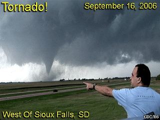
A weak boundary was also oriented W to E with a temperature change of about 5 degrees (cooler at 84 F near Sioux Falls, SD) as well as a dryline bulge nudging in from it's southwest. The first cumulus was noted NW of I-29 when about 40 miles south of Sioux Falls, SD and quickly became enhanced / towering. In Sioux City, we headed west on I-90 to intercept the RAPIDLY developing storm, which had a rock-hard anvil and was already severe (then tornado) warned only 45 minutes after initiation. Verne and I made it to the I-90 and Highway 81 overpass where we stopped to observe the rapidly developing wall cloud on the base of the now supercellular storm.
This quickly became tornadic and produced a large tornado which eventually crossed this intersection. We moved east, then northeast as the first tornado, which lasted 15-20 minutes weakened. I continued with the storm north on Highway 19 then east on county road G where a second tornado, lasting about 2 minutes developed and destroyed a house. Verne and I separated at this point, but I met back up with him, and Tony Laubach near Trent, SD on CR G shortly after. We continued east towards Pipestone, MN where a third funnel 1/2 way to the ground was observed (possible 3rd tornado).
The storm continued northeast and weakened at that point. We headed back west towards I-29 to intercept a second supercell storm near Brookings, SD but got there a bit late when the storm was at its severe (bowed segment) stage. We wrapped up the chase and headed back to Sioux City, Iowa for dinner and spent the evening there.
September 17 was a travel day and included the long drive back from Sioux city, Iowa back down I-29 then east through Kansas City, MO on I-70 to Saint Louis, MO, arriving back at my apartment in Creve Cour, MO by 4:30 PM. Total mileage from Friday to Sunday was 1,451 miles
You can view a full chase report on this by clicking the link below...http://www.sky-chaser.com/mwcl2006.htm
No comments:
Post a Comment