SUMMARY OF THE CHASE
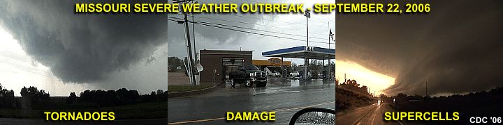
September 22 was a very interesting chase day as I was solo and chasing in my temporary "home" state of Missouri. Left Saint Louis around noon and headed to the southwest along Interstate 44. A developing low pressure area was setting up in eastern portions of Oklahoma / Kansas and backing winds were forecasted to increase in the target area, which was near Rolla, Missouri, along with a warm front, weak dryline bulge to the west, and moisture axis of high dewpoints (lower 70's). Shear was also a big factor in this case, with windfields from 850 MB all the way up to 250 MB extremely powerful, all increasing and veering with height (SSE at surface, SW at 850 MB, W at jet stream level). The core of the jet stream, starting with the exit region at well over 125 knots (at 300 MB) was already in place. Helicities were at least 500 with a forecast CAPE of 2,000.
The trip began heading southwest on I-44 to the primary target area near Rolla, MO. When stopping in Rolla and checking radar, supercells were already developing as I arrived right at the moment of initiation. This storm quickly became a supercell near Vichy, MO and developed a "flying eagle" signature on the radar image. I continued north for intercept on highway 63, and got a great view of the storm, with continuous CG lightning, a nice wall cloud, and striations on its updraft. To stay ahead of this storm, I needed to take some back roads to catch up with Highway 68 to my east, then headed southeast. The storm produced a destructive tornado which passed just 1/4 mile to my south of my position on Highway 68. Debris was noted about a thousand feet in the air, powerlines sparked, and sure enough, the grim damage path was encountered a few minutes later on the north side of Saint James, MO. The tornado was followed along I-44 out of Saint James to Cuba, MO, then farther northeast until it dissapated. The tornado lasted about 14 minutes (starting at 2:35 PM CDT).
Another supercell thunderstorm was encountered in Jefferson County east of Lonedell, Missouri near Highways 30 and 47 at about 4:30 PM. The core of this storm was encountered with golfball hail, and major damage was noted to a ranch while headed south and behind the supercell on Highway 47. This was tornado damage, but the tornado was not observed. A third supercell was encountered in Saint Francios county east of Knob Lick while headed south on Highway 67 at about 5:30 PM. This storm was observed from the backside, but a funnel / possible tornado was noted on its rear flank from about 10 miles away. This storm did produce a large wedge tornado as it crossed into Illinois later (the wedge was not observed). Finally, a fourth supercell storm was encountered near Hillsboro, Missouri along Highway 21 with incredible shelf-cloud structure, strong winds, and large hail around 7:30 PM. I wrapped up the chase and headed back north along Highway 67, then Interstate 270 to western Saint Louis (Creve Coeur) for dinner and returned to my apartment by 9:30 PM.
The full chase log and details can be found at the link below...
http://www.sky-chaser.com/mwcl2006.htm
1 comment:
The Storm Prediction Center has issued a high risk for severe weather across the central Plains and Missouri Valley, including parts of Nebraska, Kansas, Missouri, Iowa, Minnesota and South Dakota.
The warned region includes a large area with a 10% or greater probability of EF2-EF5 tornadoes, hail 2" or larger and hurricane-force winds.
akkirocks
Addiction Recovery Missouri
Post a Comment